

Ready to explore Athabasca Falls? Here's everything you need to know before you go!
Discover the trail
Trail description
Description
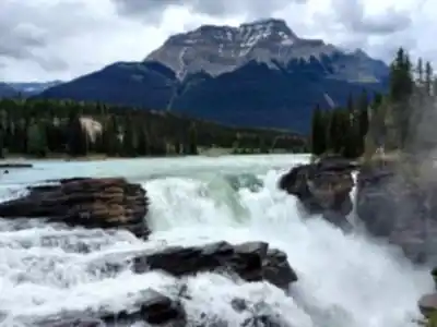
Athabasca Falls is one of the most powerful and visually dramatic waterfalls in the Canadian Rockies. Located along the Icefields Parkway in Alberta, it sits at the point where the Athabasca River forces itself through a narrow quartzite gorge before dropping in a thunderous cascade. Despite being one of the most accessible natural landmarks in the region, it never feels like a letdown — the sheer force of the water and the sculpted canyon walls make a strong impression no matter how many times you've seen photos of it.
The trail itself is short and easy, covering about 1.5 km with only 30 metres of elevation change. Most visitors complete the loop in around 30 minutes, though it's easy to linger longer once you're standing at the viewpoints. The path is well-maintained and paved in sections, making it accessible to a wide range of visitors, including families with young children and those with limited mobility on parts of the route.
The Falls and the Gorge
What makes Athabasca Falls stand out isn't its height — it's the volume and force of the water. The Athabasca River is wide and fast-moving, and when it hits the gorge, all of that energy gets compressed into a narrow channel before plunging over the drop. The result is a roar you can hear well before you see the falls, and a constant mist that hangs in the air around the main viewpoint.
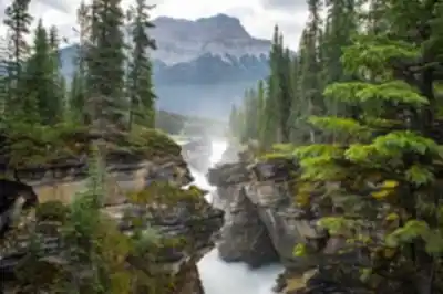
The gorge itself is worth as much attention as the falls. Over thousands of years, the river has carved deep potholes and smooth channels into the quartzite bedrock. You can see the evidence of where the falls once stood further downstream — the canyon walls tell the story of the river slowly eating its way upstream over time. The rock formations are striking, and the contrast between the dark stone and the turquoise-green water is something that photographs well but looks even better in person.
The Trail Experience
The loop trail takes you to several different vantage points around the falls and gorge. You'll get views from above, from the side, and from downstream where the canyon narrows and the water rushes through tight walls of rock. Each viewpoint gives you a different perspective on the same feature, which is part of why the short distance doesn't feel like a limitation.
The trail surface is a mix of paved paths, packed gravel, and wooden bridges. Guardrails and fencing are in place at the most exposed viewpoints. The terrain is flat to gently rolling, with no significant climbs or technical sections. It's a genuinely easy walk, and the 30-metre elevation figure reflects that — you're not gaining or losing much as you move around the perimeter of the gorge.
Practical Information
- Distance: 1.5 km loop
- Elevation gain: 30 m
- Difficulty: Easy
- Estimated time: 30 minutes
- Location: Along the Icefields Parkway, Alberta, within Jasper National Park
- Park pass required: Yes — a valid Parks Canada pass is required to access the site
- Parking: There is a dedicated parking lot at the trailhead
When to Go
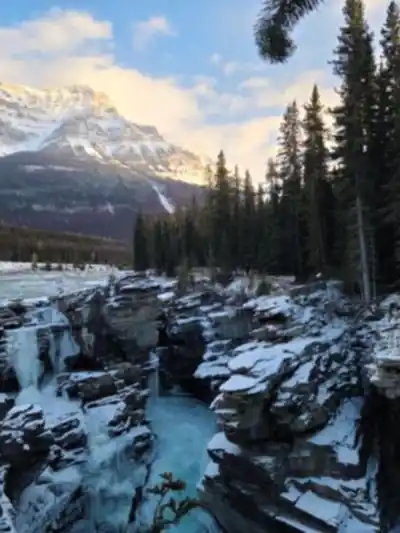
The falls are most powerful in late spring and early summer when snowmelt from the surrounding mountains feeds the Athabasca River at its peak flow. During this period, the volume of water going over the falls is at its highest, and the mist around the main viewpoint can be heavy enough to soak you if you stand close. By late summer, the flow decreases noticeably, but the falls remain impressive and the gorge is just as photogenic. The site is accessible for much of the year, though winter conditions can make the paths icy and some viewpoints may be closed for safety.
Getting There
Athabasca Falls is located on the Icefields Parkway (Highway 93), roughly 30 kilometres south of the town of Jasper. It's a straightforward stop along one of the most scenic drives in Canada, and it pairs naturally with other Icefields Parkway destinations. The parking lot is well-signed from the highway and can fill up quickly during peak summer months, so arriving earlier in the day is a good idea if you want to avoid the crowds and find a spot without waiting.
Whether you're making a dedicated trip or stopping on your way through the Rockies, Athabasca Falls delivers an experience that's hard to match for the effort involved — raw geological power, beautifully carved rock, and one of the most accessible canyon views in Alberta.
Recommended gear for this trail


Ready to go?
Everything you need to know before you goStarting Point
The athabasca falls are located in Jasper National Park, Alberta. The easiest way to get there is to drive from Edmonton, Alberta. Take Highway 16 west to Jasper and then follow the signs to the falls.
When?
How much?
- Hiking shoes Essential
- → Salomon Elixir Tour Mid WP · 203.38 $
- Layered clothing Essential
- Rain jacket Essential
- Trekking poles
- → Black Diamond Trail Ergo Cork · 69.99 $
- Headlamp
- → Petzl Actik Core 625 · 103.95 $
FAQ - Frequently asked questions
Everything you need to knowThe Essential Hiking Checklist
Everything you need for your next hike. Bilingual, printable, 1 page.
Download the free checklistSimilar hikes nearby
Discover other trails you might enjoy

Fossil Mountain
Canadian Rockies
Snake Indian Mountain
Canadian Rockies
Mushroom Peak
Canadian Rockies
Mount Woolley
Canadian Rockies
Stutfield Peak
Canadian Rockies
Mount Sarbach
Canadian Rockies
Hiking near Jasper
82 trails to explore ~27 km away
We work hard to provide the most up-to-date and error-free data possible. If something seems incorrect, let us know! Your contribution helps the whole community.
Hikers' opinions