


Ready to explore Boom Lake? Here's everything you need to know before you go!
Discover the trail
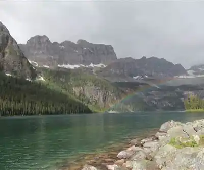
Photos: Thank you for visiting my page from Canada — CC BY 2.0 (Wikimedia Commons)
Trail description
Boom Lake is one of those hikes along the Icefields Parkway that doesn't get nearly the attention it deserves. Tucked between Banff and Lake Louise off Highway 93, it delivers a genuine alpine lake experience without the shoulder-to-shoulder crowds you'll find at some of the more famous destinations in the area. At 4.4 kilometers one-way with only 145 meters of elevation gain, it's a moderate trail that punches well above its difficulty rating when it comes to the payoff.
Getting There
The trailhead sits right off Highway 93, with clear signage that makes it easy to spot whether you're heading north from Banff or south from Lake Louise. Parking is available at the trailhead. This is Parks Canada territory, so a valid national park pass is required.
The Trail
From the trailhead, the path pulls you immediately into dense forest — spruce and fir closing in on both sides, the kind of thick canopy that keeps things cool and shaded even on warm summer days. That's one of the underrated qualities of this hike: the forest cover makes it genuinely comfortable in July and August when exposed trails in the Rockies can feel punishing.
The grade is steady but never brutal. With only 145 meters of elevation gain spread over 4.4 kilometers, you're climbing gently rather than grinding uphill. Most hikers find a comfortable rhythm early and keep it all the way to the lake. The trail is well-defined throughout, though expect muddy sections in spring or after significant rainfall — proper footwear matters here.
As you move deeper into the backcountry, the forest occasionally breaks open to offer glimpses of the surrounding peaks. These partial views build anticipation without giving away the full picture, which makes the arrival at the lake feel genuinely earned.
Plan on roughly 2 hours and 30 minutes for the round trip, though most people end up spending more time than that once they reach the lake.
Boom Lake
The lake sits directly beneath the peaks of the Continental Divide, and the setting is everything you'd hope for. Glacier-fed and crystal clear, the water reflects the surrounding mountains with the kind of clarity that makes you stop and just look for a while. On calm mornings especially, the reflection is nearly perfect — the kind of scene that makes you understand why people drive hours to hike in the Canadian Rockies.
What sets Boom Lake apart from some of the more visited alpine lakes in the region is the relative quiet. The shoreline has rocky outcrops and spots to sit, eat lunch, and take in the view without feeling like you're competing for space. The scale feels intimate despite the dramatic mountain backdrop.
The water is glacier-fed and cold — genuinely cold — so swimming is more of a quick dip situation than a leisurely swim, even in midsummer.
Wildlife and Safety
This is active wildlife habitat. Deer are commonly spotted along the trail, and the area sees bear activity — both black bears and grizzlies. Bear spray is not optional here; carry it and know how to use it. Make noise on the trail, especially in the forested sections where visibility is limited. Proper food storage is essential if you're stopping for a meal at the lake.
What to Bring
- Bear spray — mandatory in this area
- Water — more than you think you need, especially if you plan to linger at the lake
- Lunch or substantial snacks — the lake is a natural stopping point and you'll want to stay a while
- Hiking boots or sturdy trail shoes — the trail can be muddy and the 8.8-kilometer round trip rewards proper footwear
- Layers — mountain weather shifts quickly, and the lake sits in a cooler microclimate than the trailhead
- National park pass — required for access
Best Time to Visit
The trail is typically accessible from late spring through fall, with peak conditions in July and August. Early morning visits offer the best chance at calm water and those mirror-like reflections at the lake. Fall brings cooler temperatures and changing colors in the forest, making it a strong alternative to the busy summer season. Winter access is possible on snowshoes, though conditions vary significantly and travel times increase considerably.
Check current trail conditions with Parks Canada before heading out, particularly in early season when snow and ice can linger on the trail well into June.
Recommended gear for this trail
As an Amazon Associate I earn from qualifying purchases.


Ready to go?
Everything you need to know before you goStarting Point
The boom lake trails are located in Kananaskis Country, Alberta. To get to the start of the trails, take the Trans-Canada Highway (Hwy 1) west to the Kananaskis Village exit. Turn left onto Kananaskis Lakes Trail and drive for about 5 km until you reach the signed parking area for boom lake.
When?
How much?
As an Amazon Associate I earn from qualifying purchases.
Affiliate links — LGPO may earn a commission at no extra cost to you.
- Hiking shoes Essential
- → Salomon Elixir Tour Mid WP · 203.38 $
- Layered clothing Essential
- Rain jacket Essential
- Trekking poles
- → Black Diamond Trail Ergo Cork · 69.99 $
- Headlamp
- → Petzl Actik Core 625 · 103.95 $
FAQ - Frequently asked questions
Everything you need to know
25 hikes under 2 hours from Montreal
Distance, elevation, parking and season for each one. The ones we go back to ourselves.
Get the guideSimilar hikes nearby
Discover other trails you might enjoy
Fossil Mountain
Canadian Rockies

Snake Indian Mountain
Canadian Rockies
Mushroom Peak
Canadian Rockies
Mount Woolley
Canadian Rockies
Stutfield Peak
Canadian Rockies
Mount Sarbach
Canadian Rockies
Hiking near Banff
187 trails to explore ~39 km away
We work hard to provide the most up-to-date and error-free data possible. If something seems incorrect, let us know! Your contribution helps the whole community.
Hikers' opinions
Be the first to review!
No hiker has shared their experience yet. Share your impressions and help other hikers!