


Ready to explore Crowfoot Mountain? Here's everything you need to know before you go!
Discover the trail
Trail description
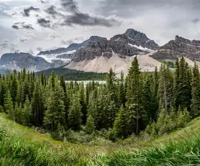
Crowfoot Mountain is one of those Alberta destinations that earns its reputation through sheer presence. Rising dramatically from the surrounding landscape of Alberta North, this peak draws hikers who are looking for a genuine mountain experience — the kind where the terrain demands your full attention and rewards you with scenery that's hard to put into words.
The mountain's name is no accident. As you gain elevation and start looking back at the massif from different angles, the distinctive shape that inspired the name becomes clear. It's one of those natural details that sticks with you long after the hike is done.
The Terrain
Crowfoot Mountain is a serious undertaking. With an elevation gain of 3,055 metres, this is not a casual outing — it's a full commitment that will test your fitness, your gear, and your decision-making. That kind of vertical gain puts it firmly in the category of objectives that require solid preparation and a clear head about turnaround conditions.
The lower sections of the approach move through forested terrain where the trees provide cover and the grade is manageable. This part of the hike gives you time to settle into your rhythm before the mountain starts asking harder questions. As you move upward, the forest gives way to more open alpine terrain, and the exposure increases along with the views. The transition is gradual but unmistakable — at some point you look up and realize the summit is still a long way above you, and you look down and realize how far you've already come.
The upper mountain is where the route gets technical and the terrain becomes more demanding. Rocky slopes, potential snow depending on the season, and the physical toll of sustained elevation gain all factor into the experience. This is the kind of mountain where your pace slows, your breathing deepens, and every step forward feels earned.
What to Expect on the Way Up
The scale of the elevation gain means you'll move through several distinct environments on a single outing. Dense lower forest, open subalpine slopes, rocky ridgelines, and the exposed upper mountain each have their own character. Wildlife sightings are possible throughout — birds of prey are often spotted riding thermals above the ridges, and the quieter sections of trail can produce encounters with the animals that call this mountain home.
The views build steadily as you climb. By the time you're well into the alpine zone, the surrounding peaks and valleys of Alberta North spread out in every direction. On a clear day, the scale of the Rocky Mountain landscape from this vantage point is genuinely impressive — the kind of panorama that makes the effort feel completely justified.
Preparation and Gear
Given the elevation gain involved, preparation here is not optional. A few things worth taking seriously before you head out:
- Footwear: Sturdy hiking boots with solid ankle support are essential. The upper terrain is rocky and uneven, and trail runners that work fine on gentler hikes may not cut it here.
- Layers: Mountain weather in Alberta can shift fast. What starts as a warm morning at the trailhead can turn cold and windy at elevation. Bring a wind layer and something warm regardless of the forecast.
- Water: The combination of sustained physical effort and elevation means you'll go through water faster than you expect. Carry more than you think you need.
- Start early: With a climb of this magnitude, an early start gives you the best chance of reaching the upper mountain in stable conditions and getting back down before afternoon weather moves in.
- Know your limits: The elevation gain of 3,055 metres is significant. Having a clear turnaround time and sticking to it is good practice on any big mountain objective.
Check current conditions before you go. Snow can linger on the upper mountain well into summer, and early season or late season attempts may require additional gear and experience.
Responsible Visiting
The alpine environment on Crowfoot Mountain is fragile. Vegetation at high elevation grows slowly and takes a long time to recover from damage. Staying on established routes, avoiding shortcuts across open slopes, and packing out everything you bring in are the basics — and they matter here more than on lower-elevation trails where the ecosystem is more resilient.
Wildlife in the area deserves space. If you encounter animals on the trail, give them room and resist the urge to approach for a closer look or a better photo. Observing from a distance is better for the animals and, honestly, often produces a more memorable experience anyway.
Crowfoot Mountain is the kind of objective that stays with you — a serious climb in a spectacular setting that delivers exactly what Alberta North's mountain landscape promises to those willing to put in the work.
Recommended gear for this trail
As an Amazon Associate I earn from qualifying purchases.


Ready to go?
Everything you need to know before you goStarting Point
The crowfoot mountain trails can be accessed from the crowfoot mountain parking lot. The crowfoot mountain parking lot is located off of Highway 1A, approximately 9 km east of the Town of Canmore.
When?
How much?
As an Amazon Associate I earn from qualifying purchases.
Affiliate links — LGPO may earn a commission at no extra cost to you.
- Hiking shoes Essential
- → Salomon Elixir Tour Mid WP · 203.38 $
- Layered clothing Essential
- Rain jacket Essential
- Trekking poles
- → Black Diamond Trail Ergo Cork · 69.99 $
- Headlamp
- → Petzl Actik Core 625 · 103.95 $
FAQ - Frequently asked questions
Everything you need to know
25 hikes under 2 hours from Montreal
Distance, elevation, parking and season for each one. The ones we go back to ourselves.
Get the guideSimilar hikes nearby
Discover other trails you might enjoy
Fossil Mountain
Canadian Rockies

Snake Indian Mountain
Canadian Rockies
Mushroom Peak
Canadian Rockies
Mount Woolley
Canadian Rockies
Stutfield Peak
Canadian Rockies
Mount Sarbach
Canadian Rockies
Hiking near Banff
187 trails to explore ~78 km away
We work hard to provide the most up-to-date and error-free data possible. If something seems incorrect, let us know! Your contribution helps the whole community.
Hikers' opinions
Be the first to review!
No hiker has shared their experience yet. Share your impressions and help other hikers!