

Ready to explore Grassi Lakes? Here's everything you need to know before you go!
Discover the trail
Trail description
Description
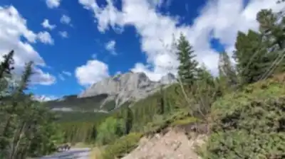
The Grassi Lakes trail is one of the most rewarding short hikes near Canmore, Alberta, leading to two brilliant emerald-colored alpine lakes tucked at the base of towering limestone cliffs in the Canadian Rockies. Located within Canmore Nordic Centre Provincial Park, part of the Kananaskis Country park system, this trail packs an impressive amount of scenery, geology, and history into a compact 3.5-kilometer route that most hikers complete in about an hour and fifteen minutes.
The Trail
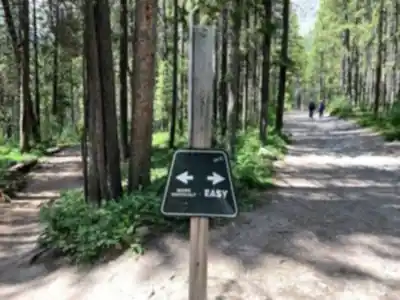
The hike gains 149 meters of elevation and is rated easy, making it accessible to a wide range of fitness levels, including families with older children. The trail begins with a steady but gentle ascent through mixed forest, following a path originally built by Lawrence Grassi in the early 20th century. The route stays well-maintained throughout, though the final approach to the lakes involves some rocky terrain and basic boulder scrambling — nothing technically demanding, but worth knowing about if you're hiking with young kids or less sure-footed companions.
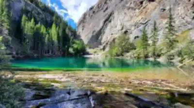
As the trees thin out, the canyon setting reveals itself gradually, building anticipation before the lakes come into full view. The contrast between the vivid turquoise water and the stark grey limestone cliffs rising approximately 75 meters above the shoreline is genuinely striking — the kind of scene that stops you mid-step. The water's distinctive color comes from fine glacial sediment suspended in the lake, the same optical effect you see in larger glacial lakes throughout the Rockies, just on a more intimate scale.
The Lakes
There are two lakes — a smaller upper lake and a larger lower lake — separated by a short rocky section that's easy to cross. Both are fed by water from the Spray Lakes Reservoir on the Spray River, which helps maintain their color and water level year-round. The rocky shorelines offer plenty of flat spots to sit, eat lunch, and take in the cliffs above. It's a natural stopping point, and most hikers spend a good chunk of time here before heading back or continuing further into the canyon.
Geology and Rock Climbing
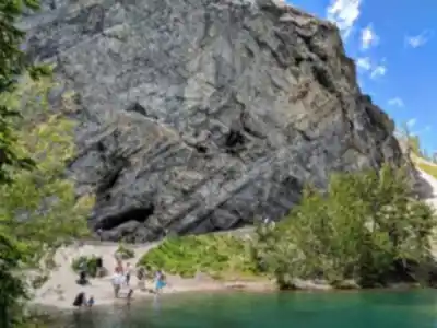
The limestone cliffs surrounding the lakes belong to the Cairn Formation, an ancient fossil reef that developed during the Late Devonian period. The primary reef-building organisms were stromatoporoids — an extinct type of bulbous sponge — whose remains created the pocketed, textured surface visible across the rock faces today. These natural pockets happen to make excellent hand and foot holds, which is why the Grassi Lakes cliffs have become a well-known rock climbing destination. Climbers of varying experience levels use the area, and it's common to see people on the walls while you're hiking or relaxing by the water.
Pictographs and Human History
Beyond the lakes, the canyon holds another layer of history worth exploring. Rock paintings believed to be more than 1,000 years old are located further up the canyon, past the main lake viewpoints. These pictographs were created by ancestors of the Kootenai people and represent one of the more significant cultural sites accessible on a short day hike in the Canmore area. Reaching them requires additional hiking beyond the lakes, but it's a worthwhile extension if you have the time and energy.
Lawrence Grassi
The lakes are named after Lawrence Grassi (1890–1980), an Italian immigrant who arrived in Canada in 1912 and became one of the most respected trail builders and climbing guides in the Canadian Rockies. He initially worked for the Canadian Pacific Railway before settling into coal mining in Canmore in 1916, but his real legacy was the network of trails he built throughout the region. The Grassi Lakes trail is his most visited work, and it remains largely unchanged from his original construction — a testament to how well he read the terrain and built for longevity.
What Else to Know
Photography is a natural draw here, and the light shifts dramatically throughout the day as it moves across the cliffs and water. Early morning tends to offer calmer conditions and fewer people on the trail. The area is popular, especially on summer weekends, so arriving earlier in the day makes for a more relaxed experience.
In winter, the Canmore Nordic Centre's groomed trail network extends through the area, making it a popular destination for cross-country skiing and snowshoeing. The frozen lakes and snow-covered cliffs offer a completely different but equally compelling landscape for those willing to visit in colder conditions.
Spring hikers should be prepared for muddy or icy sections, particularly in the shadier stretches of the trail where snowmelt lingers. Late spring and early summer bring wildflower blooms along the route, adding color to the forest sections before the open canyon takes over.
Anglers interested in fishing the lakes should check current Alberta regulations before heading out, as rules can vary by season and water body within the provincial park system.
Recommended gear for this trail


Ready to go?
Everything you need to know before you goStarting Point
The grassi lakes are located in the Canmore area of Alberta. To get to the start of the trails, take the Trans-Canada Highway (Highway 1) to the exit for Highway 40. Take Highway 40 south to the town of Canmore. In Canmore, take the exit for the grassi lakes. The trailhead is located at the end of the road.
When?
How much?
- Hiking shoes Essential
- → Salomon Elixir Tour Mid WP · 203.38 $
- Layered clothing Essential
- Rain jacket Essential
- Trekking poles
- → Black Diamond Trail Ergo Cork · 69.99 $
- Headlamp
- → Petzl Actik Core 625 · 103.95 $
FAQ - Frequently asked questions
Everything you need to knowThe Essential Hiking Checklist
Everything you need for your next hike. Bilingual, printable, 1 page.
Download the free checklistSimilar hikes nearby
Discover other trails you might enjoy

Fossil Mountain
Canadian Rockies
Snake Indian Mountain
Canadian Rockies
Mushroom Peak
Canadian Rockies
Mount Woolley
Canadian Rockies
Stutfield Peak
Canadian Rockies
Mount Sarbach
Canadian Rockies
Hiking near Canmore
200 trails to explore ~4 km away
We work hard to provide the most up-to-date and error-free data possible. If something seems incorrect, let us know! Your contribution helps the whole community.
Hikers' opinions