

Ready to explore Kananaskis Pass? Here's everything you need to know before you go!
Discover the trail
Trail description
Description
Kananaskis Pass sits in the heart of the Canadian Rockies, offering hikers a genuine mountain experience just an hour's drive from Calgary. This destination strikes that perfect balance between accessibility and wilderness feel—close enough for a day trip, yet remote enough to leave city noise far behind.
The Trail Experience
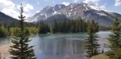
The trail system around Kananaskis Pass caters to hikers across the skill spectrum, with well-marked paths that take you through distinctly different mountain environments. You'll start by threading through dense forests where the canopy filters sunlight into dappled patterns on the trail. The sound of your footsteps on pine needles and the occasional crack of a branch underfoot becomes your hiking soundtrack.
As you gain elevation through the moderate terrain, the forest opens up and you'll find yourself crossing sparkling mountain streams—some small enough to step over, others requiring a bit more careful rock-hopping. The trail designers did their homework here; the paths are clearly marked and maintained, so you can focus on the scenery rather than worrying about route-finding.
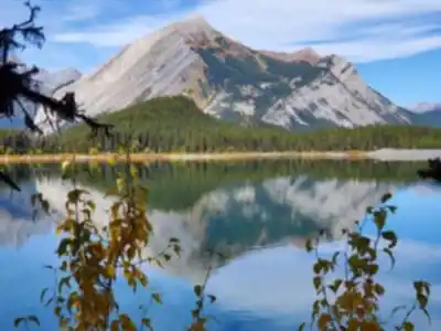
The real payoff comes at the panoramic viewpoints scattered throughout the area. These aren't just quick glimpses through trees—you'll emerge onto open ridges and elevated meadows where the full scope of the Canadian Rockies spreads out before you. Towering peaks rise in every direction, their rocky faces catching light differently throughout the day. Below, verdant valleys stretch toward the horizon, dotted with crystal-clear alpine lakes that reflect the surrounding mountains like natural mirrors.
Terrain and Physical Challenge
The moderate difficulty rating makes Kananaskis Pass accessible to most hikers with basic fitness levels. The elevation gain builds gradually rather than hitting you with steep, punishing climbs right from the start. You'll notice the altitude as you work your way up through different ecological zones, but the well-graded trail keeps the effort manageable.
Rocky sections require some attention to foot placement, especially when wet, but nothing that demands technical scrambling skills. The trail surface varies from soft forest floor to rocky alpine terrain, giving your legs a good workout without being overly demanding. Stream crossings add variety to the hiking experience—most have stepping stones or small log bridges, though spring runoff can make some crossings more challenging.
Plan on spending about five hours to fully experience what Kananaskis Pass offers. This isn't a race to the top and back down; the terrain rewards those who take time to appreciate the changing landscapes and pause at the viewpoints that make this area special.
Wildlife and Natural Features
Kananaskis Pass sits in prime wildlife habitat, and you'll want to keep your eyes open and your camera ready. Deer are common sightings, often grazing in the meadows during early morning or late afternoon hours. Elk frequent the area too, particularly during shoulder seasons. These impressive animals command respect—they're beautiful to observe but give them plenty of space.
Bear encounters are possible in this region, so proper bear safety protocols apply. Make noise on the trail, carry bear spray, and know how to use it. Most bears will avoid human contact if they hear you coming, but it's always better to be prepared. Store food properly and pack out all garbage—this keeps both you and the wildlife safe.
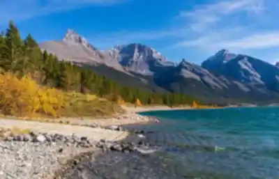
The landscape itself tells the story of geological forces at work over millions of years. The towering peaks around Kananaskis Pass showcase the dramatic limestone and shale formations characteristic of this part of the Rockies. You'll notice how the rock layers are tilted and folded, evidence of the massive tectonic forces that pushed these mountains skyward.
Seasonal Considerations
Each season transforms Kananaskis Pass into a different outdoor playground. During summer months, the trails open up fully and wildflower-filled meadows burst with color. Alpine forget-me-nots, Indian paintbrush, and mountain avens create natural gardens at higher elevations. This is prime time for hiking and mountain biking, with long daylight hours and generally stable weather.
Fall brings its own magic as aspen groves turn brilliant gold against the evergreen backdrop. The air is crisp, bugs are minimal, and wildlife becomes more active as animals prepare for winter. It's an excellent time for photography, though weather can be more unpredictable.
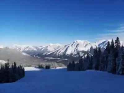
Winter completely reimagines the landscape. Snow blankets the peaks and valleys, creating a pristine wonderland perfect for snowshoeing and cross-country skiing. The trails you hiked in summer become winter routes through a transformed environment. The silence of a snow-covered forest is profound—broken only by the whisper of wind through pine boughs and the crunch of snow underfoot.
Spring can be tricky timing-wise. Lower elevations may be clear while higher trails remain snow-covered well into June. Check current conditions before heading out, as trail access can vary significantly depending on snowpack and recent weather.
Planning Your Visit
The hour-long drive from Calgary makes Kananaskis Pass an ideal escape from urban life without requiring a major expedition. The transition from city to wilderness happens gradually as you drive west—first through foothills, then into increasingly dramatic mountain terrain.
Weather in the mountains changes quickly and can be dramatically different from conditions in Calgary. Even on warm summer days, temperatures can drop significantly at higher elevations. Layering is essential—start with moisture-wicking base layers, add insulating mid-layers, and always pack a waterproof shell. Mountain weather can shift from sunny to stormy in minutes.
Pack more water than you think you'll need. Mountain air is dry, and you'll be working harder at elevation. Snacks are important too—your body burns more calories in mountain environments. A basic first aid kit, headlamp, and emergency whistle should be standard gear, even on day hikes.
The well-marked trails don't eliminate the need for basic navigation skills. Carry a map and know how to use it. Weather can roll in quickly, reducing visibility and making even familiar trails challenging to follow.
What Makes This Place Special
Kananaskis Pass represents the Canadian Rockies at their most accessible. You get the full mountain experience—dramatic peaks, alpine meadows, wildlife encounters, and that sense of wilderness solitude—without needing advanced mountaineering skills or multi-day expedition planning.
The diversity of terrain keeps things interesting. You're not just walking through one type of environment; you're experiencing the full transition from montane forest through subalpine zones and into true alpine terrain. Each elevation band has its own character, its own plant communities, and its own views.
The proximity to Calgary means you can be sitting in morning traffic and standing on a mountain ridge by lunch time. Yet once you're on the trails, the city feels like it belongs to another world entirely. That accessibility combined with genuine wilderness character makes Kananaskis Pass a standout destination in a region full of spectacular hiking opportunities.
Recommended gear for this trail


Ready to go?
Everything you need to know before you goStarting Point
The kananaskis pass is located in Alberta, Canada. To get to the start of the trails, take the Trans-Canada Highway (Highway 1) to the Kananaskis Country exit. From there, follow the Kananaskis Trail (Highway 40) to the kananaskis pass.
When?
How much?
- Hiking shoes Essential
- → Salomon Elixir Tour Mid WP · 203.38 $
- Layered clothing Essential
- Rain jacket Essential
- Trekking poles
- → Black Diamond Trail Ergo Cork · 69.99 $
- Headlamp
- → Petzl Actik Core 625 · 103.95 $
FAQ - Frequently asked questions
Everything you need to knowThe Essential Hiking Checklist
Everything you need for your next hike. Bilingual, printable, 1 page.
Download the free checklistSimilar hikes nearby
Discover other trails you might enjoy

Fossil Mountain
Canadian Rockies
Snake Indian Mountain
Canadian Rockies
Mushroom Peak
Canadian Rockies
Mount Woolley
Canadian Rockies
Stutfield Peak
Canadian Rockies
Mount Sarbach
Canadian Rockies
Hiking near Canmore
200 trails to explore ~50 km away
We work hard to provide the most up-to-date and error-free data possible. If something seems incorrect, let us know! Your contribution helps the whole community.
Hikers' opinions