

Ready to explore Lake Minnewanka? Here's everything you need to know before you go!
Discover the trail
Available trails
| Trails | Distance | Elevation | Duration | Difficulty | GPX |
|---|---|---|---|---|---|
| 17.27 km | 4h | GPX |
Trail description
Description
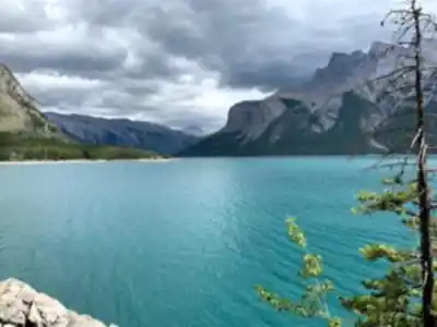
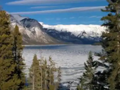
Lake Minnewanka — pronounced min-uh-WONG-kuh — takes its name from the Nakoda language, where it means "Water of the Spirits." Stretching 21 kilometers through the eastern reaches of Banff National Park, just five kilometers northeast of the Banff townsite, it holds the distinction of being the longest lake in the Canadian Rockies' mountain parks. That record owes something to human engineering: a power dam built at the lake's western end in 1941 raised water levels by 30 meters, expanding what was already a significant body of water into something that feels closer to an inland sea than a typical mountain lake.
The lake runs 13 miles long and reaches depths of 466 feet, fed primarily by the Cascade River flowing from the east side of Cascade Mountain. Additional streams cascade down from Mount Inglismaldie, Mount Girouard, and Mount Peechee along the southern shore, keeping the lake well-supplied year-round. The Cascade River enters through Stewart Canyon, carving a dramatic passage through limestone before emptying into the lake's western end — one of the most photogenic spots in the entire area.
The Hike
The trail described here covers 16 kilometers with 544 meters of elevation gain, rated hard, with an estimated time of 5 hours 30 minutes. That puts it in a different category than the casual shoreline stroll many visitors do near the parking area. You're committing to a full day out, and the terrain earns that hard rating as you move further from the trailhead and the path climbs away from the lakeshore.
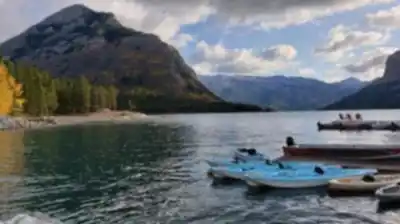
Access starts at the western end of the lake via Lake Minnewanka Road, which branches off from the Trans-Canada Highway. The parking area is large and well-signed, with boat tours operating from the same location during summer. From here, the trail follows the northern shoreline, passing through Stewart Canyon early on before pushing deeper into the valley. The surface transitions from packed gravel near the trailhead to natural dirt as you gain distance and elevation. Mountain bikers share the wider sections closer to the parking area, so stay aware of traffic in both directions on those stretches.
Stewart Canyon itself is worth slowing down for. The Cascade River has cut deep channels through the limestone here, creating pools and cascades that make for a natural rest stop and some of the best photography on the route. Past the canyon, the trail opens up along the northern shore with the full scale of the lake coming into view — Mount Aylmer rising to 3,162 meters on the northern skyline, and the continuous wall of Mount Inglismaldie, Mount Girouard, and Mount Peechee lining the southern shore across the water.
Terrain and Landscape
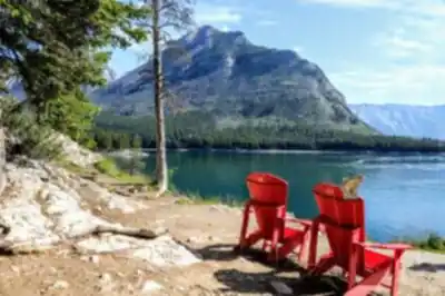
The valley Lake Minnewanka sits in was shaped by glacial forces, and that origin shows in every direction. The surrounding peaks are steep and rocky, their upper reaches holding snow well into summer. Along the shoreline, the trail alternates between rocky outcrops — good spots to stop and take in the view — and small beaches where glacial silt creates surprisingly soft ground underfoot.
The southern mountains feed the lake with countless seasonal waterfalls and permanent streams, so the sound of moving water is a near-constant companion on the trail. As you gain elevation on the harder sections, the perspective on the lake shifts, and the full length of the water becomes visible in a way that's genuinely impressive. This is a big piece of landscape, and the trail gives you the distance to appreciate its scale.
Wildlife
The Lake Minnewanka area supports a wide range of wildlife, and sightings are common enough that you should be prepared rather than surprised. Elk graze in the meadows near the shoreline, most reliably during early morning and evening. Mule deer move through the forest and along the water's edge throughout the day. Mountain sheep navigate the steeper terrain on the surrounding peaks and are occasionally visible from the trail with binoculars.
Both black bears and grizzly bears live in this area. Carry bear spray, make noise on the trail — especially in dense vegetation or near running water where sound carries poorly — and follow proper food storage practices at all times. The wildlife density here reflects over 10,000 years of human and animal use of this valley, with archaeological evidence including Clovis point spearheads and stone tools confirming just how long this place has drawn living things to its shores.
What Makes This Place Different
Lake Minnewanka has something most mountain lakes don't: an entire submerged village. The 1941 dam construction flooded the resort community of Minnewanka Landing, which had operated since 1888. The remains of that community — buildings, bridge pilings, and the original 1912 dam structure — now sit beneath the lake's surface, preserved by the cold, clear water. This has made Lake Minnewanka one of the few mountain lakes in Canada with an established recreational scuba diving scene. During low water periods, some structural remains are visible in the shallower areas even without diving gear.
The dam itself represents a significant piece of Canadian infrastructure history, built to supply hydroelectric power to the growing town of Banff. The expansion came at the cost of displacing the people who lived at Minnewanka Landing — a history worth keeping in mind as you move through a landscape that looks entirely natural but carries layers of human story beneath the surface.
Seasonal Notes
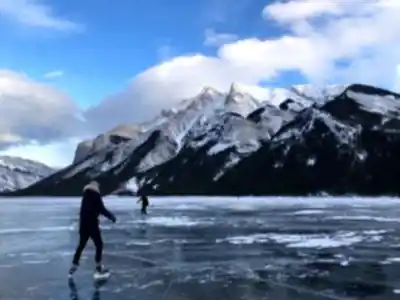
Summer offers the most straightforward conditions, with all trail sections typically clear of snow and boat tours running on the lake. The lake's size moderates shoreline temperatures, often keeping things a few degrees warmer than the surrounding terrain. Fall brings excellent wildlife activity as animals move and feed before winter, and the deciduous vegetation adds color against the evergreen slopes. Winter can make the backcountry sections of the trail demanding, and the dam's operation creates unpredictable ice conditions on the lake surface — avoid travel on the ice. Spring brings high water from snowmelt and dramatic ice breakup on the lake.
Six backcountry campsites connect along the trail system for those planning overnight trips, making it possible to experience the lake across different times of day and in changing weather — a worthwhile way to see a place this large on its own terms.
Recommended gear for this trail


Ready to go?
Everything you need to know before you goStarting Point
The easiest way to get to the start of the trails at the lake minnewanka is to drive to the Banff townsite and then take the lake minnewanka scenic drive. The scenic drive is about 20 km long and it will take you around the entire lake. The start of the trails is located at the east end of the lake near the dam.
When?
How much?
- Hiking shoes Essential
- → Salomon Elixir Tour Mid WP · 203.38 $
- Layered clothing Essential
- Rain jacket Essential
- Trekking poles
- → Black Diamond Trail Ergo Cork · 69.99 $
- Headlamp
- → Petzl Actik Core 625 · 103.95 $
FAQ - Frequently asked questions
Everything you need to knowThe Essential Hiking Checklist
Everything you need for your next hike. Bilingual, printable, 1 page.
Download the free checklistSimilar hikes nearby
Discover other trails you might enjoy

Fossil Mountain
Canadian Rockies
Snake Indian Mountain
Canadian Rockies
Mushroom Peak
Canadian Rockies
Mount Woolley
Canadian Rockies
Stutfield Peak
Canadian Rockies
Mount Sarbach
Canadian Rockies
Hiking near Banff
187 trails to explore ~17 km away
We work hard to provide the most up-to-date and error-free data possible. If something seems incorrect, let us know! Your contribution helps the whole community.
Hikers' opinions