

Ready to explore Marmot Basin? Here's everything you need to know before you go!
Discover the trail
Trail description
Description
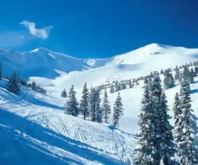
Marmot Basin is one of the more underrated summer destinations in the Canadian Rockies. Most people know it as a ski resort, but from late June through early October, the mountain opens up to hikers who want fast access to genuine alpine terrain without spending half the day just getting there. The base sits at around 1,700 meters elevation, which means you're already well into the high country before you've taken a single step on trail.
The resort is located 19 kilometers up Marmot Basin Road from Jasper townsite, a steady climb through the forest that deposits you at a parking area surrounded by open subalpine slopes. From there, the landscape does the work — wide meadows, scattered stands of Engelmann spruce and subalpine fir, rocky ridgelines, and the kind of big sky that reminds you why people come to Jasper National Park in the first place.
The Trail Network
The trail system here is a mix of dedicated hiking routes and ski runs that double as informal paths during summer. That combination gives you a lot of flexibility. You can stick to well-defined trails with clear footing, or you can follow the open ski slopes uphill toward the ridgelines — both approaches work, and both offer different perspectives on the terrain.
The full route through the basin covers approximately 15 kilometers with around 300 meters of elevation gain, which puts it squarely in moderate territory. Plan for about 6.5 hours on the trail if you're taking your time, stopping to look around, and not rushing through the upper sections. The elevation gain is spread out enough that it never feels brutal, but the exposed upper terrain and the altitude mean you'll want to pace yourself, especially if you're coming from lower elevations.
Shorter loops are available for hikers who want a taste of the alpine without committing to a full day. These stay closer to the base area, involve less total climbing, and are well-suited to families or anyone who wants to spend a few hours in the mountains without a major undertaking. The terrain on these shorter options is still genuinely alpine — you're not walking through a parking lot — but the stakes are lower and the turnaround points are obvious.
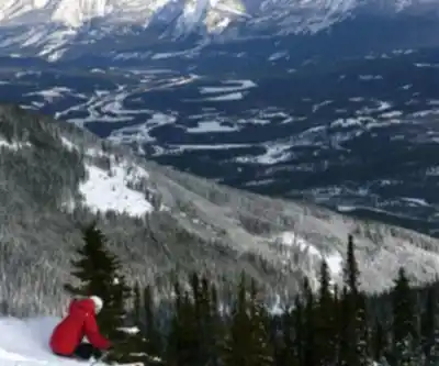
For hikers looking to push further, the routes that climb toward the surrounding ridgelines are the real draw. The views from the upper elevations take in the Athabasca Valley and the peaks of the Maligne Range, and on a clear day the scale of the landscape is hard to overstate. The upper terrain is more exposed and involves steeper grades, but nothing here requires technical climbing skills.
Wildlife and What You'll Actually See
The area lives up to its name. Hoary marmots are common throughout the basin, and the open terrain makes them easy to spot — you'll often hear their sharp warning whistles before you see them. Early morning and evening are the best times for marmot activity, though they're around throughout the day. Pika are also present in the rockier sections, and various high-altitude bird species are regular sights along the upper routes.
Both black bears and grizzly bears inhabit the Jasper National Park backcountry, and Marmot Basin is no exception. The open terrain actually works in your favor here — you can often see a long way across the slopes, which gives you time to react if you spot a bear at a distance. That said, standard bear country protocols apply: make noise, carry bear spray, and store food properly.
The plant communities shift noticeably as you gain elevation. Lower sections have more tree cover and subalpine shrubs, while the upper terrain opens into true alpine zones with low-growing wildflowers and exposed rock. In July and August, the wildflower displays in the meadows can be genuinely impressive — the short growing season concentrates everything into a few weeks of intense color.
Seasonal Conditions
The hiking season runs roughly from late June through early October, though early-season conditions often include snow patches on north-facing slopes and in sheltered areas. July and August offer the most reliable trail access and the warmest temperatures, along with peak wildflower season. September is worth considering if you prefer fewer people on the trail — conditions are often still good, the light is different, and the crowds thin out considerably, though you should be ready for colder temperatures and the real possibility of early snowfall.
Weather at this elevation changes fast. Afternoon thunderstorms are common during summer, and the exposed ridgeline terrain offers no shelter when they roll in. Start early, watch the sky, and carry rain gear and extra layers regardless of what the morning looks like.
Getting There and Practical Details
Marmot Basin Road climbs from Highway 93A through a series of switchbacks to reach the base area. The road is well-maintained in summer but demands attention, particularly in wet conditions. Parking is available at the base, though on busy summer weekends the lots can fill up — arriving early is the straightforward solution.
A valid Jasper National Park pass is required. No additional fees apply for hiking during summer months. Washroom facilities and some basic services are available at the base area during the summer season, but treat these as a bonus rather than a guarantee and come self-sufficient.
Dogs are welcome on the trails but must remain on leash at all times, consistent with Jasper National Park regulations. Given the wildlife activity in the area, leash compliance isn't just a rule — it's genuinely important.
Water sources within the basin are limited, so carry more than you think you'll need. The combination of elevation, sun exposure, and dry summer conditions means your water consumption will likely be higher than on lower-elevation hikes. A filter or purification tablets give you flexibility if you find a reliable stream, but don't count on it.
Families with younger children will find the shorter base-area loops manageable, but should be aware that even these routes involve real elevation and exposure — appropriate footwear, layering, and supervision matter here just as much as on the longer routes.
Recommended gear for this trail


Ready to go?
Everything you need to know before you goStarting Point
The cross-country ski trailhead at marmot basin is located on the north side of the resort, accessed from the town of Jasper. From Jasper, drive north on Highway 93 for approximately 10 km until you reach the marmot basin turnoff on your left. Turn left and drive 1.5 km to the trailhead parking lot.
When?
How much?
- Hiking shoes Essential
- → Salomon Elixir Tour Mid WP · 203.38 $
- Layered clothing Essential
- Rain jacket Essential
- Trekking poles
- → Black Diamond Trail Ergo Cork · 69.99 $
- Headlamp
- → Petzl Actik Core 625 · 103.95 $
FAQ - Frequently asked questions
Everything you need to knowThe Essential Hiking Checklist
Everything you need for your next hike. Bilingual, printable, 1 page.
Download the free checklistSimilar hikes nearby
Discover other trails you might enjoy

Fossil Mountain
Canadian Rockies
Snake Indian Mountain
Canadian Rockies
Mushroom Peak
Canadian Rockies
Mount Woolley
Canadian Rockies
Stutfield Peak
Canadian Rockies
Mount Sarbach
Canadian Rockies
Hiking near Jasper
82 trails to explore ~8 km away
We work hard to provide the most up-to-date and error-free data possible. If something seems incorrect, let us know! Your contribution helps the whole community.
Hikers' opinions