

Ready to explore Mount Athabasca? Here's everything you need to know before you go!
Discover the trail
Available trails
| Trails | Distance | Elevation | Duration | Difficulty | GPX |
|---|---|---|---|---|---|
| 12.7 km | 1537 m | 5h30 | Expert | GPX |
Trail description
Description
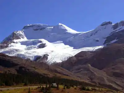
Mount Athabasca rises 3,491 meters (11,453 feet) above sea level in the heart of Jasper National Park, forming part of the legendary Columbia Icefield in the Canadian Rockies. This imposing peak draws mountaineers and hikers from around the world with its dramatic glaciated slopes and commanding presence along the Icefields Parkway. While the mountain itself requires serious mountaineering skills to summit, the surrounding area offers experiences for hikers of varying abilities who want to explore one of Alberta's most spectacular alpine environments.
The mountain's location within the Columbia Icefield makes it a centerpiece of one of the largest accumulations of ice and snow south of the Arctic Circle. Its striking glaciers cascade down steep faces, creating a landscape that shifts between brilliant white ice fields and dark rocky ridges. The sheer scale of the terrain here dwarfs visitors, offering a humbling reminder of the raw power of geological forces that shaped the Canadian Rockies.
The North Glacier Route
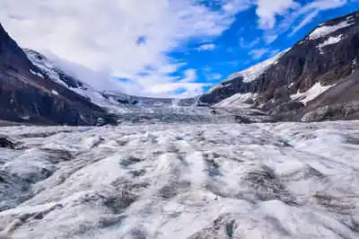
The most popular ascent follows the North Glacier route, which provides the most accessible path to the summit for those with basic mountaineering experience. This 12.7-kilometer route gains 1,537 meters of elevation and represents a very hard difficulty level that demands respect and preparation. The climb combines snow and ice travel across varied terrain, transitioning from approach hiking through alpine meadows to technical glacier navigation requiring crampons and ice axes.
The route begins with a steady approach through subalpine terrain before reaching the glacier proper. Once on the ice, climbers encounter a mix of moderate slopes punctuated by steeper sections and occasional crevasse fields. The final push to the summit involves navigating around seracs and ice formations that change seasonally. Weather conditions can shift rapidly at this elevation, with temperatures dropping significantly and winds picking up without warning.
This ascent typically requires a full day for experienced parties, though many climbers opt for an alpine start to take advantage of more stable morning conditions on the glacier. The technical nature of the route makes it essential to have proper mountaineering gear and either significant personal experience with glacier travel or the guidance of a certified mountain guide.
Base Area Trails
For hikers not ready to tackle glacier travel but still wanting to experience the majesty of this region, numerous trails wind around the base of Mount Athabasca. These routes provide stunning perspectives of the surrounding peaks and valleys without requiring technical climbing skills or specialized mountaineering equipment. The trails offer excellent vantage points for photography and wildlife observation while keeping hikers on solid ground.
These lower-elevation routes showcase the diverse ecosystems that thrive in the shadow of the great peaks. Hikers pass through dense subalpine forests of Engelmann spruce and subalpine fir before emerging into open meadows dotted with wildflowers during the brief summer growing season. The contrast between the lush valley floors and the stark, icy peaks above creates some of the most photographed landscapes in the Canadian Rockies.
Wildlife and Natural Features
The Mount Athabasca area supports diverse wildlife populations adapted to the harsh alpine environment. Mountain goats navigate the steep rocky slopes with remarkable agility, often visible as white specks against the dark cliff faces. Hoary marmots inhabit the boulder fields and meadows, their sharp whistles echoing across the valleys as they warn of approaching hikers. The region also falls within grizzly bear habitat, and these powerful predators occasionally traverse the area, particularly during late summer when they forage for berries and ground squirrels.
The pristine landscapes surrounding Mount Athabasca showcase the raw beauty of high alpine environments. Massive glacial moraines tell the story of ice ages past, while active glaciers continue to carve and reshape the terrain. The interplay of ice, rock, and sky creates an ever-changing canvas of light and shadow that captivates visitors throughout the day.
Essential Planning Information
Weather conditions in this high alpine environment can be unpredictable and change rapidly. Checking current weather forecasts and avalanche reports before any trip is crucial for safety. Even during summer months, temperatures can drop below freezing, and sudden storms can bring snow and whiteout conditions. The climbing season typically runs from late spring through early fall, but conditions vary significantly year to year.
Proper gear selection makes the difference between a successful adventure and a dangerous situation. For glacier routes, crampons and ice axes are essential, along with appropriate mountaineering boots and clothing systems designed for alpine conditions. Even for base area hikes, layers suitable for rapidly changing mountain weather are necessary. A helmet is recommended for all routes due to potential rockfall hazards.
Safety should always be the top priority when venturing into this terrain. Those unfamiliar with glacier travel should strongly consider hiring a certified guide who knows the current route conditions and can provide instruction in crevasse rescue techniques. Mountain rescue in this remote area can be complicated and time-consuming, making prevention through proper preparation and decision-making essential.
The popularity of Mount Athabasca means that peak season weekends can see significant traffic on the standard routes. Planning visits during weekdays or shoulder seasons often provides a more tranquil experience and better opportunities for wildlife observation. The Leave No Trace principles are particularly important in this pristine environment – pack out all waste, stay on established routes where they exist, and minimize impact on the fragile alpine ecosystem.
Recommended gear for this trail


Ready to go?
Everything you need to know before you goStarting Point
The mount athabasca is located in Alberta. To get to the start of the trails, take Highway 93 north from Lake Louise to the Icefields Parkway. Turn west onto the Icefields Parkway and drive to the end of the road at the Athabasca Glacier. There is a parking lot and trailhead at the end of the road.
When?
How much?
- Hiking shoes Essential
- → Salomon Elixir Tour Mid WP · 203.38 $
- Layered clothing Essential
- Rain jacket Essential
- Trekking poles
- → Black Diamond Trail Ergo Cork · 69.99 $
- Headlamp
- → Petzl Actik Core 625 · 103.95 $
FAQ - Frequently asked questions
Everything you need to knowThe Essential Hiking Checklist
Everything you need for your next hike. Bilingual, printable, 1 page.
Download the free checklistSimilar hikes nearby
Discover other trails you might enjoy

Fossil Mountain
Canadian Rockies
Snake Indian Mountain
Canadian Rockies
Mushroom Peak
Canadian Rockies
Mount Woolley
Canadian Rockies
Stutfield Peak
Canadian Rockies
Mount Sarbach
Canadian Rockies
Hiking near Jasper
82 trails to explore ~98 km away
We work hard to provide the most up-to-date and error-free data possible. If something seems incorrect, let us know! Your contribution helps the whole community.
Hikers' opinions