

Ready to explore Mount Edith Cavell? Here's everything you need to know before you go!
Discover the trail
Trail description
Description
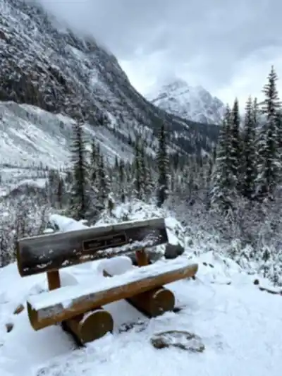
Mount Edith Cavell rises dramatically from the heart of Jasper National Park, its 3,363-meter (11,033-foot) summit dominating the skyline above the Athabasca Valley. Named after British nurse Edith Cavell, who was executed during World War I for helping Allied soldiers escape German-occupied Belgium, this peak carries both historical weight and raw natural power. It's one of the most recognizable mountains in the Canadian Rockies — and one of the few places where you can stand face-to-face with an active glacier after just a short walk from the parking lot.
Two Trails, Two Experiences
Most visitors come to Mount Edith Cavell for one of two trails, and they couldn't feel more different from each other despite sharing the same trailhead.
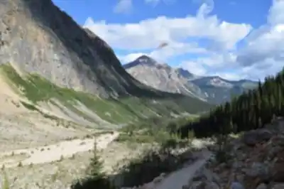
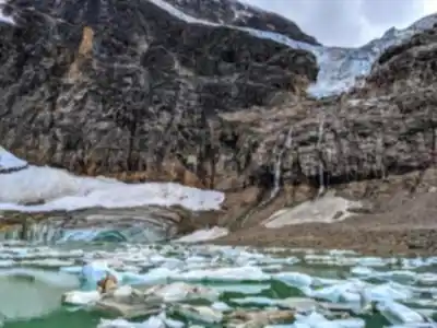
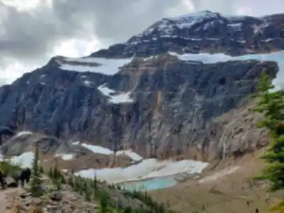
The Path of the Glacier Trail is the shorter option — a 1.6-kilometer (1-mile) round trip that stays relatively flat and delivers some of the most dramatic scenery in the Rockies with minimal physical effort. The trail crosses ancient moraine, the rocky debris left behind as Angel Glacier has retreated over decades, and leads directly to Cavell Pond at the base of the mountain's north face. The pond's milky turquoise water often holds floating icebergs well into summer, calved from the glacier above. The scale of what you're looking at takes a moment to register: dark limestone cliffs rising hundreds of meters overhead, a glacier clinging to the wall, and that impossibly colored water below. It's the kind of view that earns its reputation.
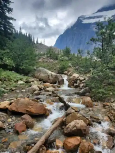
The Cavell Meadows Trail is a different proposition entirely — an 8.5-kilometer (5.3-mile) loop that climbs into the high alpine country surrounding the mountain. From the same parking area, this trail branches off and ascends through subalpine forest before breaking out into open meadows. During peak season, those meadows fill with Indian paintbrush, mountain avens, and alpine forget-me-nots. As you gain elevation, the perspective on Mount Edith Cavell and Angel Glacier keeps shifting, offering views you simply can't get from the valley floor. The loop design means you're not retracing your steps, which makes the experience feel more complete.
Terrain and What to Watch For
The Path of the Glacier Trail is accessible to most visitors, but "easy" doesn't mean "smooth." The surface is rocky throughout — loose stones, polished bedrock, and uneven moraine — so proper footwear matters. The rocks near Cavell Pond can be slippery when wet, and they often are. Take your time near the water's edge.
The Cavell Meadows Trail demands more from your legs and your attention. The forest section can be muddy early in the season, and the upper portions cross exposed ridges where weather can shift without much warning. The higher you climb, the more the terrain opens up, which is spectacular on a clear day and humbling when clouds roll in.
Wildlife is part of the experience throughout the area. Hoary marmots are almost guaranteed — you'll hear their sharp warning whistles before you see them. Pikas work the rocky slopes near the glacier, constantly moving vegetation to their winter caches. Grizzly bears use the meadows and forest edges, particularly during late summer berry season, so making noise while you hike is standard practice here, not optional.
When to Go
The trails at Mount Edith Cavell are typically accessible from mid-June through early October, though that window shifts depending on the previous winter's snowpack and spring conditions. Snow lingers on the Cavell Meadows Trail well into early summer, and early snowfall can close things down again in September.
Mid-July through August is peak wildflower season in the meadows and also the busiest period on the mountain. September is worth considering — conditions are generally good, the crowds thin out noticeably, and the light has a quality that photographers tend to appreciate. Just be prepared for cooler temperatures and the possibility of early snow at elevation.
Afternoon thunderstorms are common throughout summer. The exposed terrain on the upper sections of the Cavell Meadows Trail offers no shelter, so an early start is smart for more than one reason.
Getting There and Parking
The access road to Mount Edith Cavell climbs steeply from the Athabasca Valley floor and is not suitable for large RVs or trailers. The road is narrow and winding, and the trailhead parking area is limited in size. During peak season, that lot fills early — often before mid-morning. Getting there early isn't just a suggestion; it's the practical reality of visiting one of the most popular destinations in Jasper National Park.
Check current trail conditions and any temporary closures before heading out. Bear management measures occasionally restrict access to parts of the area, and conditions on the access road can change with weather.
Staying on the Right Side of the Terrain
The alpine environment around Mount Edith Cavell is genuinely fragile. The growing season at this elevation is short, and vegetation that gets trampled can take years to recover. Staying on designated trails isn't just a rule — it's the reason the meadows look the way they do. Pack out everything you bring in, store food properly given the bear activity in the area, and give wildlife the space they need to go about their business undisturbed.
The moraine near Angel Glacier is also an active environment — ice calves into Cavell Pond periodically, and the area immediately around the pond deserves respect for that reason as much as any other.
Recommended gear for this trail


Ready to go?
Everything you need to know before you goStarting Point
To access the hiking trails, head to the parking lot located at the end of mount edith cavell Road. From Jasper, drive south on Highway 93 (Icefields Parkway) for about 7 kilometers and then turn right onto Highway 93A. Continue for approximately 5.4 kilometers before turning right onto mount edith cavell Road. Follow this road for about 14 kilometers until you reach the parking area at the trailhead. Note that the road is typically open from mid-June to mid-October, depending on weather conditions.
When?
How much?
- Hiking shoes Essential
- → Salomon Elixir Tour Mid WP · 203.38 $
- Layered clothing Essential
- Rain jacket Essential
- Trekking poles
- → Black Diamond Trail Ergo Cork · 69.99 $
- Headlamp
- → Petzl Actik Core 625 · 103.95 $
FAQ - Frequently asked questions
Everything you need to knowThe Essential Hiking Checklist
Everything you need for your next hike. Bilingual, printable, 1 page.
Download the free checklistSimilar hikes nearby
Discover other trails you might enjoy

Fossil Mountain
Canadian Rockies
Snake Indian Mountain
Canadian Rockies
Mushroom Peak
Canadian Rockies
Mount Woolley
Canadian Rockies
Stutfield Peak
Canadian Rockies
Mount Sarbach
Canadian Rockies
Hiking near Jasper
82 trails to explore ~23 km away
We work hard to provide the most up-to-date and error-free data possible. If something seems incorrect, let us know! Your contribution helps the whole community.
Hikers' opinions