

Ready to explore Mount Hector? Here's everything you need to know before you go!
Discover the trail
Trail description
Description
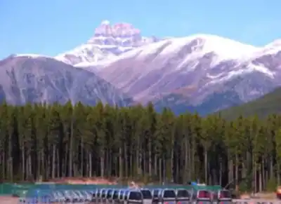
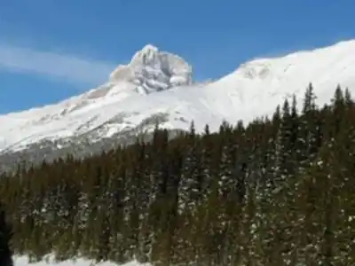
Mount Hector stands at 3,394 meters (11,135 feet) in Banff National Park, making it one of the more serious objectives accessible from the Icefields Parkway. At 14.1 km round trip with 1,550 meters of elevation gain and an estimated 7.5 hours on the mountain, this is a full commitment — not a casual day hike. It draws experienced scramblers and mountaineers who want a genuine challenge without the crowds that pack the Lake Louise and Moraine Lake corridors.
Getting to the Trailhead
The trailhead sits at Hector Creek along Highway 93 (Icefields Parkway). There's no formal parking lot — you're looking for a shoulder pull-off near the creek crossing. Arrive early during summer weekends, as space is limited and the Parkway sees heavy traffic during peak season. The drive itself along Highway 93 is worth the trip regardless, but don't let the scenery distract you from the task ahead.
The Route
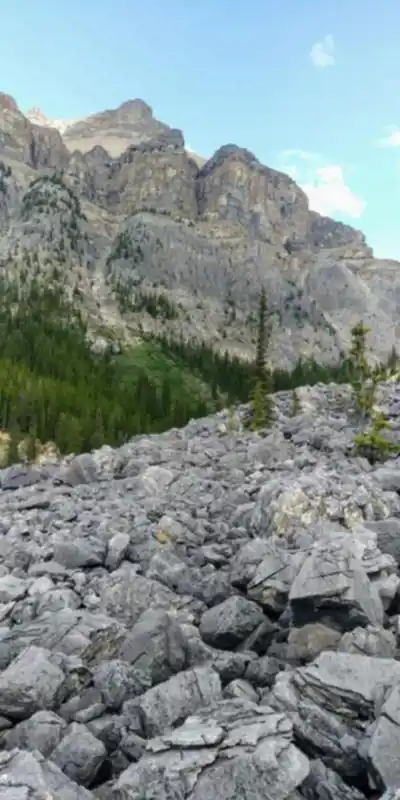
The climb begins in dense montane forest — spruce and fir providing shade and a bit of shelter before the terrain opens up. This lower section is where navigation demands your attention early. The route isn't a groomed trail with regular signage; you need solid map and compass skills, and a GPS device is a smart addition. Don't rely on cairns alone to find your way.
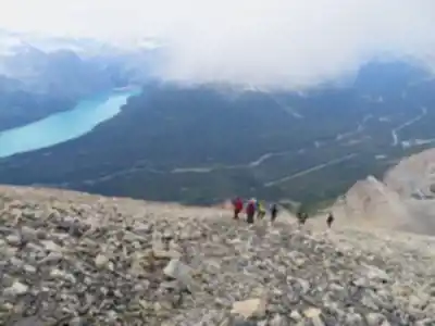
As you gain elevation, the forest transitions into subalpine meadows. In summer, these open areas fill with wildflowers — paintbrush, alpine forget-me-nots, mountain avens — set against the gray limestone backdrop that defines the Canadian Rockies. This is also where you get your first clear look at the summit, which tends to look closer than it actually is. Don't be fooled.
The upper mountain is where Mount Hector earns its Hard rating. The final push involves scrambling over loose scree and rocky slopes where foot placement matters with every step. The limestone can be slick when wet, and dislodging rocks onto climbers below is a real hazard. This section crosses the line from hiking into genuine scrambling — you're using your hands, reading the terrain, and making judgment calls about the safest line. If that sounds unfamiliar, this isn't the right mountain for your current skill level.
Timing and Weather
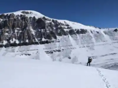
Starting before dawn is standard practice for Mount Hector. The exposed upper slopes offer zero shelter, and afternoon thunderstorms are a consistent threat throughout summer. Getting to the summit and beginning your descent before midday significantly reduces your exposure to lightning risk on the open rocky terrain. Weather in the Rockies can shift from clear skies to a full storm in under an hour at this elevation — plan accordingly and be genuinely prepared to turn around if conditions change.
Wildlife
The elevation zones on Mount Hector support a range of wildlife. In the lower forested sections, black bears and grizzlies are present, particularly during late summer berry season — carry bear spray and know how to use it. Higher up in the alpine, mountain goats navigate the cliffs with ease, and you may spot them on ledges that look completely inaccessible. Marmots are common in the meadow zones and will announce your presence loudly. Pikas work the rocky areas, and golden eagles frequently ride thermals above the upper peaks.
The limestone itself tells a longer story — fossilized marine life occasionally surfaces in the rock, remnants of when this entire region sat beneath a shallow tropical sea hundreds of millions of years ago.
Gear and Preparation
This mountain requires proper mountaineering boots with solid ankle support — trail runners won't cut it on the upper scree. Depending on the season and conditions, microspikes or lightweight crampons may be necessary, particularly earlier in summer when snow lingers on the upper slopes. Layered clothing is non-negotiable; temperatures at the summit can drop sharply even on warm valley days.
- Navigation: Topographic map, compass, GPS — all three. The route requires active navigation throughout.
- Water: Carry enough for the full day. Lower sections have water sources, but alpine streams aren't guaranteed.
- Food: High-energy snacks and a real lunch. This is a 7.5-hour day under good conditions.
- Communication: Cell coverage along the Parkway is unreliable and essentially nonexistent on the upper mountain. A satellite communicator is worth carrying.
- Helmet: Not required, but experienced scramblers often wear one when other parties are above — loose rock is a consistent hazard.
Safety
Leave a detailed trip plan with someone who isn't on the mountain — your expected route, turnaround time, and what to do if you don't check in. The combination of route-finding demands, technical scrambling, loose terrain, and rapidly changing weather makes Mount Hector unforgiving of poor preparation. Know your limits, set a firm turnaround time regardless of how close the summit feels, and stick to it.
For those with the experience and fitness to take it on, Mount Hector delivers sweeping views across the Continental Divide and deep into Banff National Park — the kind of summit that earns its reward.
Recommended gear for this trail


Ready to go?
Everything you need to know before you goStarting Point
The mount hector trails are located in the Kananaskis Country area of Alberta. To get to the start of the trails, take Highway 40 south from Calgary and turn left onto the Smith-Dorrien/Spray Lakes Road (Highway 742). Continue on the Smith-Dorrien/Spray Lakes Road for about 24 kilometers and turn right onto the mount hector Forest Service Road. The trailhead is located about 1 kilometer down the mount hector Forest Service Road.
When?
How much?
- Hiking shoes Essential
- → Salomon Elixir Tour Mid WP · 203.38 $
- Layered clothing Essential
- Rain jacket Essential
- Trekking poles
- → Black Diamond Trail Ergo Cork · 69.99 $
- Headlamp
- → Petzl Actik Core 625 · 103.95 $
FAQ - Frequently asked questions
Everything you need to knowThe Essential Hiking Checklist
Everything you need for your next hike. Bilingual, printable, 1 page.
Download the free checklistSimilar hikes nearby
Discover other trails you might enjoy

Fossil Mountain
Canadian Rockies
Snake Indian Mountain
Canadian Rockies
Mushroom Peak
Canadian Rockies
Mount Woolley
Canadian Rockies
Stutfield Peak
Canadian Rockies
Mount Sarbach
Canadian Rockies
Hiking near Banff
187 trails to explore ~65 km away
We work hard to provide the most up-to-date and error-free data possible. If something seems incorrect, let us know! Your contribution helps the whole community.
Hikers' opinions