

Ready to explore Panther Falls? Here's everything you need to know before you go!
Discover the trail
Trail description
Description
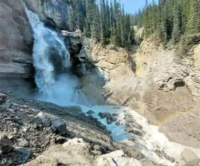
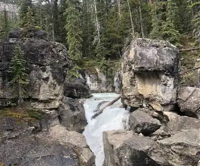
Panther Falls is one of those places along the Icefields Parkway that rewards you without asking much in return. Tucked just off the highway in the Canadian Rockies, this multi-tiered waterfall offers a genuine wilderness experience without the commitment of a full-day hike. The cascade drops in stages over layered limestone and shale, creating pools between rocky ledges and throwing a fine mist into the surrounding forest. It's not the biggest waterfall in Alberta, but the intimate setting and the way the water catches the light make it one of the more photogenic stops along the parkway.
What makes Panther Falls stand out among the many roadside waterfalls in this corridor is how quickly the forest absorbs you. Within minutes of leaving the parking area, the sound of traffic fades and the rush of water takes over. The falls stay strong through most of the hiking season, fed by snowmelt and mountain runoff that keeps the flow impressive even when conditions elsewhere are drying out.
The Trail
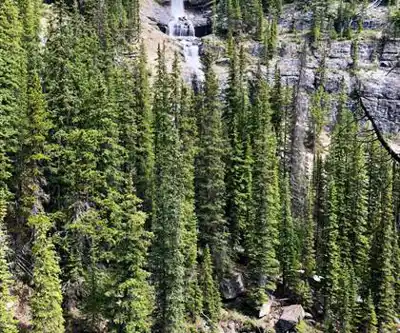
The hike covers 3.2 kilometers round trip with 150 meters of elevation gain, and most hikers complete it in around two and a half hours at a relaxed pace. The trail starts directly from the parking area along the Icefields Parkway and immediately enters a mixed forest of spruce, fir, and aspen. The grade is gentle throughout, making this an easy outing that works well for families, casual hikers, or anyone who wants a meaningful nature experience without a major physical commitment.
The path is well-marked and maintained, with a surface of packed earth, occasional root sections, and some rocky patches as you get closer to the falls. The forest canopy provides solid shade on sunny days, and the understory includes Labrador tea, wild rose, and various berry bushes typical of the boreal zone. As you move through the trees, the sound of the falls builds gradually, and you'll catch glimpses of the cascade through the forest before the trail opens up to the main viewing area.
One thing worth knowing: the trail can get muddy during wet weather or early in the season when snowmelt is running hard. Waterproof footwear is a smart call, especially if you're visiting in June or after a stretch of rain.
At the Falls
The viewing platform at Panther Falls gives you a solid look at the full structure of the cascade — the way the water drops in stages, collects briefly in rocky pools, then continues its descent. The mist from the falls keeps the surrounding rocks covered in thick moss and makes the immediate area noticeably cooler than the trail behind you, which is a welcome contrast on a warm summer day.
The platform is sturdy and offers a few different angles, but the best shots often come from moving around rather than planting yourself in one spot. Early morning and late afternoon light work particularly well here, filtering through the mist and hitting different sections of the falls as the sun moves. If you're into photography, a tripod lets you slow the shutter down and get that silky water effect that makes waterfall shots pop.
The rocks near the base of the falls are consistently wet and can be slippery. The platform is the right place to be for most visitors. If you do want to explore closer to the water, take your time and watch your footing — the combination of mist and algae on wet rock is unforgiving.
Wildlife and Natural Features
The forest around Panther Falls is active with the kind of wildlife you'd expect in this part of the Rockies. Squirrels and chipmunks are regulars along the trail, and the mix of forest and moving water draws a good variety of birds. Gray jays, Clark's nutcrackers, and various woodpeckers are common sightings, though the sound of the falls can make it harder to pick up bird calls — pausing on the trail before you reach the water gives you a better chance of hearing what's around you.
Larger animals like deer and elk are less frequently seen here than on more remote trails, partly because of the proximity to the Icefields Parkway. That said, the dense forest does provide cover, and it's always worth keeping your eyes open.
The geology at the falls is worth a closer look. The stepped structure of the cascade reflects the layered limestone and shale formations that define this section of the Rockies — rock that was laid down in ancient seabeds and then lifted, tilted, and carved by water over thousands of years. The falls have worked their way through these layers to create the distinctive tiered drop you see today.
Planning Your Visit
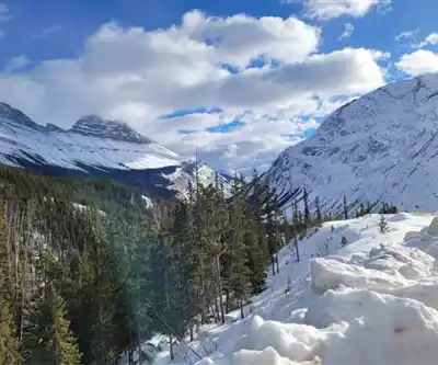
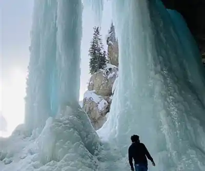
The trail is accessible from late spring through fall, with the best conditions typically running from June through September. Early season visits can mean muddy sections and snow patches on the trail, but the water flow is at its strongest. Later in the season, the falls remain impressive, though flow does taper off as the snowmelt slows.
- Footwear: Waterproof hiking boots or trail shoes with solid grip are the right call, especially near the falls where the ground stays wet.
- Water and snacks: Even on a short hike, mountain air and elevation can catch you off guard. Bring more than you think you need.
- Camera: This place photographs well from multiple angles and in different light conditions. A tripod is worth the extra weight if you want to experiment with longer exposures.
- Timing: Early morning visits tend to mean fewer people and better light for photography. Midday on weekends can get busy given the easy access from the parkway.
Leave It as You Found It
Panther Falls sits within a sensitive mountain ecosystem, and the area around the falls is especially fragile — the constant moisture supports specialized mosses and plants that don't recover quickly from foot traffic. Stay on the designated trail and use the viewing platform rather than scrambling on the rocks around the base of the falls.
Pack out everything you bring in, keep food secured, and give any wildlife you encounter plenty of space. The proximity to the Icefields Parkway means animals in this area have some exposure to humans, but that's not an invitation to close the distance or offer food — it creates problems for the animals and for the people who visit after you.
Recommended gear for this trail


Ready to go?
Everything you need to know before you goStarting Point
The panther falls trailhead is located in the Kananaskis Valley, approximately 60 km west of Calgary. To get there, take the Trans-Canada Highway (Hwy 1) to the Kananaskis Village exit and follow the signs to the park.
When?
How much?
- Hiking shoes Essential
- → Salomon Elixir Tour Mid WP · 203.38 $
- Layered clothing Essential
- Rain jacket Essential
- Trekking poles
- → Black Diamond Trail Ergo Cork · 69.99 $
- Headlamp
- → Petzl Actik Core 625 · 103.95 $
FAQ - Frequently asked questions
Everything you need to knowThe Essential Hiking Checklist
Everything you need for your next hike. Bilingual, printable, 1 page.
Download the free checklistSimilar hikes nearby
Discover other trails you might enjoy

Fossil Mountain
Canadian Rockies
Snake Indian Mountain
Canadian Rockies
Mushroom Peak
Canadian Rockies
Mount Woolley
Canadian Rockies
Stutfield Peak
Canadian Rockies
Mount Sarbach
Canadian Rockies
Hiking near Jasper
82 trails to explore ~104 km away
We work hard to provide the most up-to-date and error-free data possible. If something seems incorrect, let us know! Your contribution helps the whole community.
Hikers' opinions