

Ready to explore Pigeon Mountain? Here's everything you need to know before you go!
Discover the trail


Trail description
Description
Pigeon Mountain rises sharply from the floor of the Bow Valley like a natural fortress, its distinctive profile making it one of the most recognizable peaks in the area around Dead Man's Flats. Located within Bow Valley Wildland Provincial Park, this is a serious day hike that earns its Hard rating — covering 8.5 km with 850 m of elevation gain and a typical moving time of around 4 hours 30 minutes. It's a popular objective for Calgary-based hikers looking for a genuine mountain challenge without driving deep into the national parks.
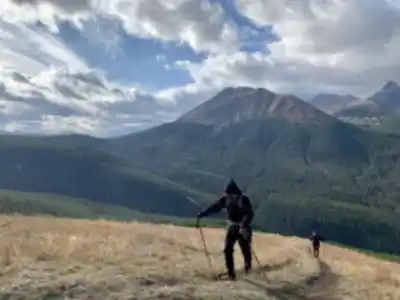
What makes Pigeon Mountain stand out isn't just the summit views — it's the variety of terrain you move through to get there. The hike transitions from dense montane forest to open subalpine slopes to exposed scrambling terrain near the top, and each zone feels distinctly different underfoot and overhead. This isn't a trail where you zone out and cruise to the top. It asks for your attention the whole way.
Trail Experience and Terrain
The trailhead sits near Dead Man's Flats, just off the Trans-Canada Highway, which makes access straightforward whether you're coming from Calgary or Canmore. The first section of the hike follows well-marked paths through thick spruce and fir forest. The grade here is moderate, footing is generally solid, and it serves as a good warm-up before the trail starts to bite.
As you gain elevation, the forest thins and the trail steepens noticeably. The middle portion involves steady climbing over increasingly rough ground — loose scree, exposed roots, and rockier footing that requires more deliberate foot placement. This is where hikers who underestimated the route start to feel it in their legs.
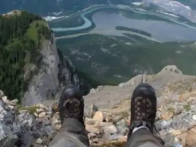
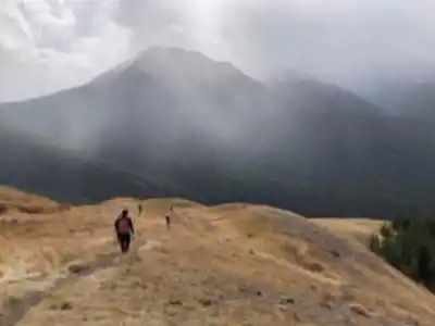
The upper section is where Pigeon Mountain earns its reputation. The defined trail gives way to cairn-marked routes over broken limestone, and the final push to the summit involves genuine scrambling on steep, exposed terrain. The rock is mostly solid limestone, but loose stones are common on the steeper pitches, and some sections have enough exposure to be unsettling for hikers without prior scrambling experience. A helmet is a smart call for this upper zone. The consequences of a slip here are serious, and this section should not be underestimated.
From the summit, the payoff is real. The Bow Valley spreads out below you, with Canmore visible to the east and the front ranges rising in every direction. On a clear day you can pick out the Three Sisters, and the more distant summits of Banff National Park fill the western horizon.
Wildlife and Natural Features
The range of habitats along Pigeon Mountain's slopes means you're moving through genuinely different ecosystems as you climb, and the wildlife reflects that. In the lower forested sections, white-tailed deer and mule deer are commonly spotted, especially on early morning starts. Gray jays and Clark's nutcrackers are a near-constant presence in the trees — bold, curious, and always worth a look.
Higher up, as the terrain opens, golden eagles and red-tailed hawks work the thermals above the ridgelines. Catching one of these birds soaring at eye level from the upper trail is one of those moments that sticks with you.
Near treeline, the alpine meadows put on a strong wildflower show through the peak summer months — Indian paintbrush, alpine forget-me-nots, and mountain avens against a backdrop of gray limestone. These ecosystems are slow to recover from damage, so staying on established paths matters here more than it does in the forest below.
Both black bears and grizzly bears inhabit this region. Encounters on the main trail are relatively uncommon given the regular foot traffic, but bear spray is non-negotiable, and making noise in areas with limited sightlines is just good practice. Store all food and scented items properly.
Seasonal Considerations
The main hiking season on Pigeon Mountain runs from late spring through early fall — roughly May through October. In late spring and early summer, the lower trail is typically clear, though snow can linger in shaded areas near the summit. Mid-summer brings the best wildflower displays and the most reliable weather, but also the heaviest weekend traffic. Early fall is a strong option: stable conditions, fewer people, and the lower elevations start showing autumn color.
Winter ascents are possible for experienced mountaineers with the right gear, but snow and ice turn the upper sections into a serious alpine undertaking. Avalanche awareness, crampons, and ice axes become necessary equipment, and the exposed scrambling terrain becomes significantly more hazardous.
What to Bring
Pigeon Mountain is not the place to show up underprepared. A few things worth having:
- Footwear: Sturdy hiking boots with solid ankle support are the minimum. Many hikers prefer lightweight mountaineering boots for the scrambling sections. Whatever you wear, it needs to handle loose rock confidently.
- Trekking poles: Useful on the steep ascent, and genuinely helpful on the descent when loose rock increases slip risk.
- Layers and rain gear: Mountain weather moves fast. Even on a warm valley day, summit temperatures can be significantly cooler, and afternoon thunderstorms are common in summer. A waterproof shell and warm layers are standard.
- Water: Carry at least two liters per person. There are no reliable water sources along the route.
- Food: High-energy snacks and a real lunch. This is a long day with sustained physical effort.
- Headlamp: Even on a day hike. Route-finding on the upper section or an unexpected delay can push your return into low light.
- Helmet: Recommended for the rockier upper sections where loose rock and exposure are both factors.
- Bear spray: Carry it where you can reach it quickly, not buried in your pack.
Hikers should have prior experience on similar scrambling terrain before attempting Pigeon Mountain — this is not an appropriate first scramble, and the upper section demands both physical fitness and comfort with exposed, technical ground.
Recommended gear for this trail


Ready to go?
Everything you need to know before you goStarting Point
The pigeon mountain trails are located in the town of Pigeon Lake, Alberta. To get to the start of the trails, take Highway 16 east from Edmonton to Wetaskiwin. In Wetaskiwin, take Highway 2 south to Pigeon Lake. The trailhead is located on the east side of the lake.
When?
How much?
- Hiking shoes Essential
- → Salomon Elixir Tour Mid WP · 203.38 $
- Layered clothing Essential
- Rain jacket Essential
- Trekking poles
- → Black Diamond Trail Ergo Cork · 69.99 $
- Headlamp
- → Petzl Actik Core 625 · 103.95 $
FAQ - Frequently asked questions
Everything you need to knowThe Essential Hiking Checklist
Everything you need for your next hike. Bilingual, printable, 1 page.
Download the free checklistSimilar hikes nearby
Discover other trails you might enjoy

Fossil Mountain
Canadian Rockies
Snake Indian Mountain
Canadian Rockies
Mushroom Peak
Canadian Rockies
Mount Woolley
Canadian Rockies
Stutfield Peak
Canadian Rockies
Mount Sarbach
Canadian Rockies
Hiking near Canmore
200 trails to explore ~12 km away
We work hard to provide the most up-to-date and error-free data possible. If something seems incorrect, let us know! Your contribution helps the whole community.
Hikers' opinions