

Ready to explore Spray Lakes Reservoir? Here's everything you need to know before you go!
Discover the trail

Available trails
| Trails | Distance | Elevation | Duration | Difficulty | GPX |
|---|---|---|---|---|---|
| 4.59 km | 1h | GPX |
Trail description
Description
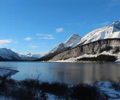
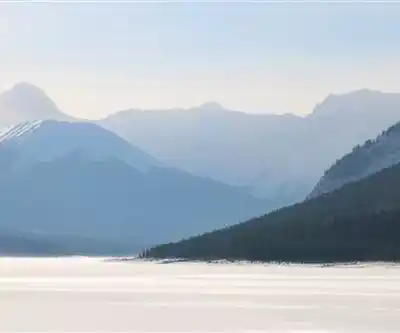
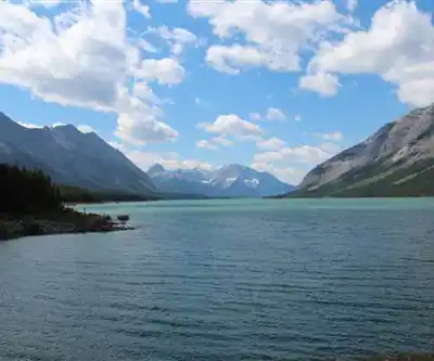
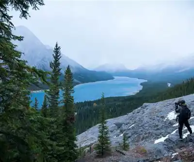
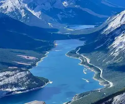
Spray Lakes Reservoir sits in the heart of Spray Valley Provincial Park, just a short drive from Canmore, and it delivers the kind of mountain scenery that makes you stop mid-stride just to take it all in. This expansive man-made lake stretches through a dramatic alpine valley, with towering peaks rising directly from the water's edge and dense forests of spruce and fir blanketing the lower slopes. On calm mornings, the reflections on the water are almost disorienting—it's the kind of place that earns its reputation quickly.
The reservoir serves as a hub for a wide range of outdoor activities, from serious mountain hiking to relaxed paddling and fishing. Whether you're based in Canmore for a weekend or making a dedicated trip into the Canadian Rockies, Spray Lakes rewards the effort to get here.
The Hiking Experience
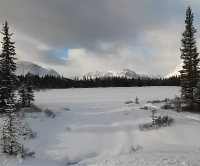
The trail network around Spray Lakes Reservoir covers a broad range of terrain and difficulty levels, making it genuinely useful for different types of hikers rather than just one crowd. The featured route clocks in at 10.6 km and is rated Hard, with an estimated moving time of around 2 hours and 40 minutes. The elevation gain is minimal, which means the challenge comes more from distance and terrain underfoot than from sustained climbing—something worth knowing before you head out.
West Wind Pass is the standout challenging route in the area. The trail climbs steadily through varied terrain, transitioning from dense lower-elevation forest into open alpine environments where the full scale of the surrounding Rocky Mountain landscape becomes apparent. The views from the pass are sweeping and well-earned, with multiple peaks and valleys visible in every direction. It's the kind of trail that experienced hikers come back to.
For a completely different experience at the same location, the Goat Creek Trail keeps things mellow. It follows the water's edge and stays close to the shoreline, making it a solid choice for wildlife watching, photography, or simply moving through the landscape without pushing hard. The contrast between this trail and West Wind Pass illustrates just how much range the Spray Lakes area actually has.
Families with kids, casual day hikers, and serious mountaineers can all find something that fits here. Easy walks connect to scenic viewpoints and natural rest spots, while the more demanding routes push into high country that requires solid fitness and proper gear.
Water Activities
The reservoir itself is a major draw beyond the trail network. The clear mountain water and protected bays make it well-suited for canoeing and kayaking—beginners can stay close to shore in calmer inlets, while more experienced paddlers can work their way along the reservoir's full length. The combination of mountain reflections and open water makes for exceptional paddling conditions on calm days.
Fishing is another strong draw. The reservoir holds trout and whitefish, and the clear water and varied underwater structure create good habitat for both species. Anglers fish from shore as well as from boats throughout the season, and the scenery makes even a slow day on the water worthwhile.
Wildlife and Natural Features
Wildlife sightings are a regular part of any visit to Spray Lakes. Deer and elk are commonly seen, especially during early morning and evening hours when they come down to drink at the water's edge. The mix of habitats around the reservoir—wetland margins, dense forest, open meadows, and alpine slopes—supports a wide variety of species beyond the obvious ones.
Both black bears and grizzly bears inhabit the region, so proper food storage and basic bear awareness are non-negotiable here. These aren't just precautions for show—this is genuinely wild country, and the presence of large predators is part of what makes it feel that way. Carry bear spray, know how to use it, and make noise on the trail.
Bird life is diverse throughout the area, and the varied ecosystems mean that what you see on a lakeside walk will be quite different from what you encounter higher up on the alpine trails. Patient observers tend to get the most out of the wildlife side of a visit here.
Camping and Overnight Options
Nearby campgrounds offer rustic sites that work well as a base for multi-day exploration of the area. The facilities are intentionally simple, which keeps the atmosphere consistent with the surrounding wilderness rather than feeling like a developed resort. Light pollution is minimal out here, and clear Alberta nights offer genuinely impressive stargazing for anyone willing to stay up for it.
The campgrounds suit both families looking for a comfortable outdoor experience and more serious adventurers who want a convenient staging point for longer routes into the backcountry.
Getting There and Planning Your Visit
Spray Lakes Reservoir's proximity to Canmore makes it one of the more accessible wilderness destinations in the Canadian Rockies. It works equally well as a day trip or as the centerpiece of a longer stay in Spray Valley Provincial Park. Day visitors can realistically cover multiple trail options and still have time for water activities, while those staying overnight can explore more remote corners of the area and experience the landscape at different times of day.
Bring layers regardless of the season—mountain weather in this part of Alberta shifts quickly, and conditions at the trailhead can be very different from what you encounter higher up. A camera is worth the extra weight in your pack; the light on the water and peaks changes constantly throughout the day, and the opportunities for strong shots are frequent.
Recommended gear for this trail


Ready to go?
Everything you need to know before you goStarting Point
To access the hiking trails in the area, you can start from several trailheads around spray lakes reservoir. Here are some options:
Spray Lakes West Campground Trailhead: Located along Spray Lakes Road (Smith-Dorrien Trail), this trailhead provides parking facilities for hikers. The campground is a convenient starting point for various trails.
Goat Creek Trailhead: Situated at the southern end of spray lakes reservoir, this trailhead is accessible via Smith-Dorrien Trail. It offers parking and serves as a gateway to multiple hiking routes.
Buller Mountain Day Use Area: Found on the eastern side of the reservoir, this day-use area has parking available and connects to several trails in the vicinity.
Ensure you check local maps and signage for specific directions to each trailhead, as road conditions can vary depending on the season.
When?
How much?
- Hiking shoes Essential
- → Salomon Elixir Tour Mid WP · 203.38 $
- Layered clothing Essential
- Rain jacket Essential
- Trekking poles
- → Black Diamond Trail Ergo Cork · 69.99 $
- Headlamp
- → Petzl Actik Core 625 · 103.95 $
FAQ - Frequently asked questions
Everything you need to knowThe Essential Hiking Checklist
Everything you need for your next hike. Bilingual, printable, 1 page.
Download the free checklistSimilar hikes nearby
Discover other trails you might enjoy

Fossil Mountain
Canadian Rockies
Snake Indian Mountain
Canadian Rockies
Mushroom Peak
Canadian Rockies
Mount Woolley
Canadian Rockies
Stutfield Peak
Canadian Rockies
Mount Sarbach
Canadian Rockies
Hiking near Canmore
200 trails to explore ~19 km away
We work hard to provide the most up-to-date and error-free data possible. If something seems incorrect, let us know! Your contribution helps the whole community.
Hikers' opinions