

Ready to explore Sulphur Mountain? Here's everything you need to know before you go!
Discover the trail

Trail description
Description
Sulphur Mountain rises 2,281 meters above sea level in Banff National Park, offering one of the most accessible summit experiences in the Canadian Rockies. Located just minutes from downtown Banff, this iconic peak draws hikers and sightseers alike with its combination of challenging trail access and convenient gondola option, making it a versatile destination for outdoor enthusiasts of all abilities.
The Hiking Experience
The Sulphur Mountain Trail presents a sustained 5.5-kilometer climb that gains 800 meters of elevation through diverse mountain terrain. The well-maintained path begins near the Banff Upper Hot Springs parking area and immediately plunges into dense montane forest dominated by Douglas fir, white spruce, and aspen. The initial section follows a series of switchbacks that help manage the consistent grade, though hikers should expect a steady uphill grind from start to finish.
As you ascend through the lower elevations, the forest canopy provides welcome shade during summer months while offering glimpses of the surrounding peaks through breaks in the trees. The trail surface consists primarily of packed earth and rock, with occasional wooden steps and bridges crossing small drainage areas. Wildlife encounters are common along this route—bighorn sheep frequently graze near the trail, particularly in the upper sections, while marmots can be spotted sunning themselves on rocky outcrops. Hikers may also encounter ground squirrels, chipmunks, and various bird species including gray jays and Clark's nutcrackers.
The middle section of the trail emerges from the dense forest into more open terrain where subalpine fir and Engelmann spruce become dominant. Here, the views begin to open up, offering tantalizing previews of the panoramic vistas awaiting at the summit. The final approach involves traversing several exposed slopes where the trail cuts across scree fields and rocky terrain, providing increasingly dramatic views of the Bow Valley below. Most hikers complete the ascent in approximately 3 hours, though the steady grade demands a moderate fitness level and proper pacing.
Summit Rewards
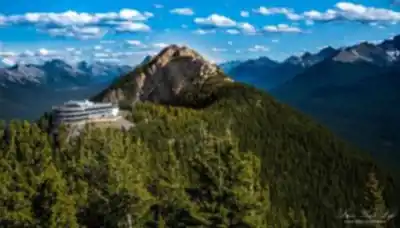
The summit experience on Sulphur Mountain extends far beyond a simple viewpoint. Upon reaching the top, hikers encounter an extensive boardwalk system that connects multiple viewing platforms and provides access to the historic Banff Gondola upper terminal. The main attraction is the sweeping 360-degree panorama that encompasses the entire Bow Valley, the town of Banff spread out like a miniature model below, and an impressive array of surrounding peaks including Mount Rundle, Cascade Mountain, and the distant summits of the Continental Divide.
Sanson's Peak, accessible via a short boardwalk extension, offers the highest viewpoint on Sulphur Mountain and houses a restored weather station that operated from 1903 to 1931. This historic structure adds cultural significance to the natural spectacle, and the elevated platform provides unobstructed views in all directions. The contrast between the developed Bow Valley corridor and the wild mountain landscape stretching to the horizon creates a uniquely Canadian Rockies perspective that captures both the region's natural grandeur and human presence.
Trail Character and Terrain
What sets Sulphur Mountain apart from other regional hikes is its consistent challenge without technical difficulty. The trail maintains a steady upward trajectory that builds endurance while remaining accessible to hikers with moderate experience. The path is wide enough for comfortable passage and features excellent drainage, making it manageable even after light precipitation. Strategic placement of benches and rest areas allows hikers to pace themselves while taking in the evolving mountain vistas.
The terrain transitions create distinct hiking zones, each offering its own character. The lower forest section provides a meditative start with dappled sunlight and the sound of wind through the canopy. The middle transition zone offers the first real taste of alpine exposure, while the upper reaches deliver the full mountain experience with expansive views and the exhilaration of approaching a significant summit.
Alternative Access Options
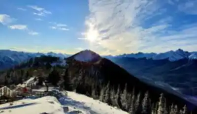
The Banff Gondola provides an eight-minute alternative route to the summit that appeals to families, visitors with mobility limitations, or anyone preferring to save their energy for exploring the summit area rather than the ascent. The enclosed four-person cabins offer panoramic windows and interpretive information during the ride, creating a different but equally engaging mountain experience. Gondola passengers can still access all the same summit facilities and viewpoints as hikers, and many visitors choose to ride up and hike down, or vice versa.
The gondola operates year-round with varying schedules, though hikers should note that trail conditions change dramatically with the seasons. Summer and early fall provide the most straightforward hiking conditions, while winter transforms the trail into a challenging snowshoe or crampon route suitable only for experienced winter hikers with proper equipment.
Seasonal Considerations
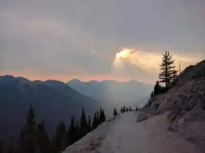
Sulphur Mountain's accessibility throughout the year comes with important seasonal variations that significantly impact the hiking experience. Summer conditions from June through September offer the most predictable trail conditions, though afternoon thunderstorms can develop quickly in the high country. Early morning starts help hikers avoid both crowds and weather complications while providing the best lighting for photography.
Spring hiking from April through May involves navigating variable snow conditions, with the lower trail sections typically clear while upper elevations may retain significant snow cover. Fall conditions from October through November can be spectacular for hiking, with golden aspen colors in the lower elevations and crisp, clear air providing exceptional visibility. However, early season snowfall can occur without warning, and hikers should be prepared for rapidly changing conditions.
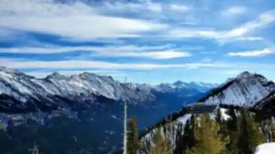
Winter hiking requires specialized equipment including microspikes or crampons, warm clothing layers, and experience with winter mountain travel. The trail becomes significantly more challenging and time-consuming under snow conditions, but rewards experienced winter hikers with a completely different mountain experience and often superior visibility due to stable high-pressure weather systems.
Post-Hike Recovery
The Banff Upper Hot Springs, located at the trailhead, provide an ideal conclusion to a Sulphur Mountain hiking adventure. These natural thermal pools maintain temperatures between 37-40°C year-round and offer the perfect remedy for tired leg muscles while providing continued mountain views. The facility includes changing rooms, towel rentals, and a relaxation area, making it convenient for hikers to transition from trail to thermal pool without extensive preparation.
The hot springs experience combines the therapeutic benefits of mineral-rich thermal water with the visual reward of soaking while surrounded by mountain peaks. This unique combination of hiking and hot springs creates a distinctly Canadian Rockies experience that sets Sulphur Mountain apart from other regional hiking destinations.
Recommended gear for this trail


Ready to go?
Everything you need to know before you goStarting Point
The sulphur mountain trails can be accessed from the Banff townsite. From the intersection of Banff Avenue and Spray Avenue, drive north on Banff Avenue for 1.5 km to the Mount Norquay Road turnoff. Turn left onto Mount Norquay Road and drive for 2.5 km to the sulphur mountain parking lot.
When?
How much?
- Hiking shoes Essential
- → Salomon Elixir Tour Mid WP · 203.38 $
- Layered clothing Essential
- Rain jacket Essential
- Trekking poles
- → Black Diamond Trail Ergo Cork · 69.99 $
- Headlamp
- → Petzl Actik Core 625 · 103.95 $
FAQ - Frequently asked questions
Everything you need to knowThe Essential Hiking Checklist
Everything you need for your next hike. Bilingual, printable, 1 page.
Download the free checklistSimilar hikes nearby
Discover other trails you might enjoy

Fossil Mountain
Canadian Rockies
Snake Indian Mountain
Canadian Rockies
Mushroom Peak
Canadian Rockies
Mount Woolley
Canadian Rockies
Stutfield Peak
Canadian Rockies
Mount Sarbach
Canadian Rockies
Hiking near Banff
187 trails to explore ~6 km away
We work hard to provide the most up-to-date and error-free data possible. If something seems incorrect, let us know! Your contribution helps the whole community.
Hikers' opinions