

Ready to explore Vermilion Lakes? Here's everything you need to know before you go!
Discover the trail
Trail description
Description
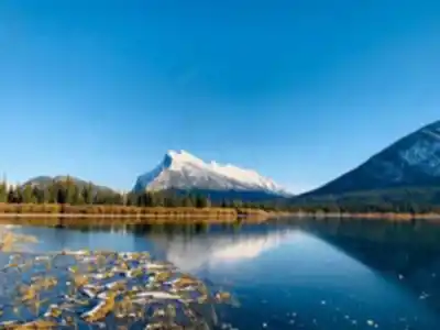
Vermilion Lakes sits just minutes from downtown Banff, yet it feels like a completely different world from the busy streets and alpine trails of the national park. This series of three interconnected wetland lakes stretches along the Bow River valley, tucked between the base of Mount Rundle to the east and the Fairholme Range to the west. The lakes formed in old river channels over time, leaving behind shallow, marshy waters that support a remarkably diverse ecosystem — one that stands in sharp contrast to the rocky, high-elevation terrain most visitors associate with Banff National Park.
What makes this place stand out isn't just the scenery, though that alone would be reason enough to visit. It's the combination of total accessibility, incredible wildlife viewing, and some of the most dramatic mountain reflections you'll find anywhere in the Canadian Rockies. Mount Rundle's eastern face catches the first light of day and mirrors perfectly in the still water below — which is why photographers regularly show up before sunrise to claim a good spot along the first lake.
The Trail
The main route follows Vermilion Lakes Drive, a 4.3-kilometre paved road that's closed to through traffic. With only 15 metres of elevation gain across the entire route, the terrain is essentially flat the whole way — making this one of the most accessible outdoor experiences in the Banff area. The estimated time to walk the full route is around 1 hour and 15 minutes at a relaxed pace, though most people end up stopping frequently to watch wildlife or take photos.
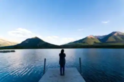
The road connects all three lakes, with informal trails branching off toward the water's edge and several boardwalks and viewing platforms built at key spots along the way. These elevated walkways let you get close to the wetland without trampling the sensitive shoreline habitat, and they double as solid platforms for photography and wildlife watching.
The first lake is the busiest, especially during golden hour. As you move toward the second and third lakes, the foot traffic drops off noticeably. The third lake, furthest from town, tends to offer the most quiet and consistently good wildlife sightings. It's worth pushing past the first lake even if the light is already perfect there.
Wildlife and Natural Features
The wetland ecosystem here supports an impressive range of wildlife. Elk are a common sight, particularly in the early morning and evening when they graze in the open meadows near the water. White-tailed deer and mule deer also move through regularly, and black bears have been spotted in the area, though the open terrain makes them less frequent visitors than in more forested parts of the park.
For birders, Vermilion Lakes is genuinely exceptional. Over 100 bird species have been recorded here. Great blue herons, osprey, bald eagles, and a wide variety of waterfowl are all regular sightings. The shallow water and dense marsh vegetation create ideal nesting conditions, and during spring and fall migration, the lakes serve as an important stopover for species moving through the mountain corridors. If you're visiting during migration season, bring binoculars.
The shorelines are thick with cattails, sedges, and willow scrub — habitat that looks nothing like the rest of Banff but supports its own food web of insects, amphibians, and small mammals. Aspen groves add another layer of habitat and turn a brilliant gold in fall, creating reflections on the water that rival the mountain views.
Photography
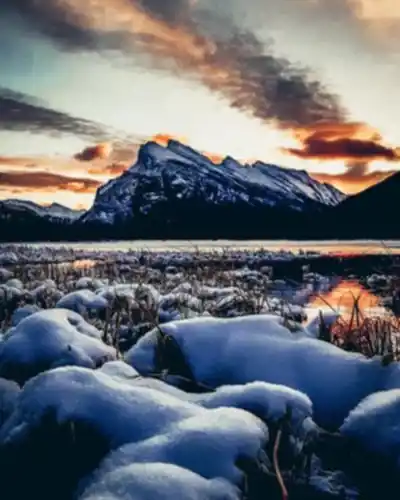
Vermilion Lakes is one of the most photographed locations in the Canadian Rockies, and the reputation is well earned. The first lake offers the classic Mount Rundle reflection shot at sunrise — the mountain's eastern face lights up in warm tones while the still water below acts like a mirror. Arrive early, especially on weekends, because the parking area fills up fast on clear mornings.
Sunset works well from any of the three lakes, with the western ranges providing strong silhouettes as the light fades. The boardwalks and viewing platforms give you stable footing and keep you out of the mud, which matters when you're trying to hold a shot steady in low light.
Wildlife photography is productive throughout the day here. The open terrain makes it easier to spot large mammals at a distance, and the variety of bird species gives photographers of every skill level something to work with.
Practical Information
Parking is available at the start of Vermilion Lakes Drive, just off the Trans-Canada Highway west of Banff. On busy weekend mornings — especially during sunrise season — the lot can fill up quickly, so arriving early pays off both for parking and for the light.
The paved road surface makes this route suitable for strollers and wheelchairs, which is relatively rare for a destination this scenic. Some of the informal side trails to the water's edge are rougher and may be harder to navigate depending on conditions. There are no washroom facilities along the route, so plan ahead before you leave town.
Bring water, particularly in summer — there's limited shade along much of the road and the walk is longer than it looks on a map. Insect repellent is a must during warmer months; the wetland environment means mosquitoes are part of the deal.
The area is open year-round. In winter, the road surface can be icy, and microspikes or traction devices are worth having. The flat terrain makes it a solid option for beginner cross-country skiers and snowshoers, and the snow-covered peaks add a whole different dimension to the scenery. The lakes often freeze over completely, opening up additional access points and winter photography angles that aren't possible in other seasons.
A valid Parks Canada pass is required for entry into Banff National Park, which covers access to Vermilion Lakes Drive.
Recommended gear for this trail


Ready to go?
Everything you need to know before you goStarting Point
The vermilion lakes are located in Banff National Park, Alberta. To get to the start of the trails, take the Trans-Canada Highway (Hwy 1) west from Calgary and turn off at the exit for Banff National Park. Follow the signs to the vermilion lakes.
When?
How much?
- Hiking shoes Essential
- → Salomon Elixir Tour Mid WP · 203.38 $
- Layered clothing Essential
- Rain jacket Essential
- Trekking poles
- → Black Diamond Trail Ergo Cork · 69.99 $
- Headlamp
- → Petzl Actik Core 625 · 103.95 $
FAQ - Frequently asked questions
Everything you need to knowThe Essential Hiking Checklist
Everything you need for your next hike. Bilingual, printable, 1 page.
Download the free checklistSimilar hikes nearby
Discover other trails you might enjoy

Fossil Mountain
Canadian Rockies
Snake Indian Mountain
Canadian Rockies
Mushroom Peak
Canadian Rockies
Mount Woolley
Canadian Rockies
Stutfield Peak
Canadian Rockies
Mount Sarbach
Canadian Rockies
Hiking near Banff
187 trails to explore ~2 km away
We work hard to provide the most up-to-date and error-free data possible. If something seems incorrect, let us know! Your contribution helps the whole community.
Hikers' opinions