


Ready to explore Upper Chedoke Falls? Here's everything you need to know before you go!
Discover the trail
Trail description
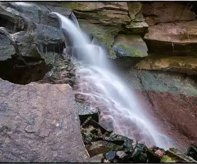
Upper Chedoke Falls is one of Hamilton's quieter waterfall gems, tucked into the escarpment along the Chedoke Radial Trail. While Hamilton is well known for its impressive collection of waterfalls, Upper Chedoke tends to draw a more local crowd than some of the region's bigger-name cascades, which means you're more likely to have a genuinely peaceful experience here. The falls drop over layered sedimentary rock that tells the geological story of the Niagara Escarpment — the same ancient formation that shapes so much of this region's character.
The water flow changes noticeably with the seasons. After heavy rain or during spring runoff, the cascade fills out considerably and the surrounding forest gets loud with the sound of rushing water. In drier stretches, the flow pulls back and exposes more of the rock face, which actually opens up different angles for photography and gives you a better look at the escarpment geology up close.
The Trail
The route to Upper Chedoke Falls follows the Chedoke Radial Trail, a path with some historical weight to it — this corridor was once part of the region's transportation network before it was converted to recreational use. That history gives the trail a slightly different feel than a purpose-built hiking path. Sections of it follow old railway grades, which means relatively flat and wide stretches, while other parts get more rugged with exposed roots, rocks, and terrain that demands a bit more attention underfoot.
The elevation gain of 52 meters is distributed across the hike rather than concentrated in one steep push, which keeps the overall effort manageable for most people. That said, the trail surface can get genuinely slippery — wet leaves in fall, mud in spring, and potentially icy patches in winter all require footwear with real grip. This isn't a place for casual sneakers when conditions are anything less than dry.
As you get closer to the falls, you'll hear them before you see them. The forest opens up around the rocky area where the water makes its descent, and the surrounding escarpment walls give the spot a natural amphitheater quality that amplifies the sound and frames the view.
What Sets This Spot Apart
Upper Chedoke Falls offers something that some of Hamilton's more popular waterfalls don't always deliver: a sense of actually being in the forest rather than standing at a designated viewpoint with a crowd. The trail context matters here — you're moving through mature mixed hardwood forest typical of the escarpment, and the falls feel like a destination you've earned rather than a drive-up attraction.
The surrounding forest supports a solid variety of birdlife, from common woodland species to raptors that use the escarpment's thermal currents. The plant communities along the trail reflect the escarpment's distinct microclimates, with species adapted to the specific conditions created by the rock face, moisture levels, and canopy cover.
For photographers, the layered rock formations at the base of the falls provide strong foreground interest, and the forest framing gives you options for compositions that place the waterfall in its natural context rather than isolating it. Morning light filtering through the canopy and the more directional light of late afternoon both produce distinct results worth planning around.
Planning Your Visit
Upper Chedoke Falls is accessible from Hamilton without a long drive, which makes it a practical choice for a half-day outing. Parking at the Chedoke Radial Trail access points can fill up on weekends, particularly during fall when the foliage is at its peak and after significant rainfall when word gets out that the falls are running strong. Arriving earlier in the day gives you better odds of finding a spot and a quieter experience on the trail.
The trail is open year-round, and each season brings a genuinely different experience:
- Spring brings the highest water volume and emerging wildflowers, but also the muddiest and most slippery trail conditions of the year.
- Summer offers the most stable footing and comfortable temperatures, though the falls may run lower during extended dry periods.
- Fall delivers the most visually dramatic combination of foliage color and waterfall — but wet leaves on the trail demand careful footing.
- Winter is possible for experienced hikers with appropriate footwear, and ice formations around the falls can be striking, but the hazard level increases significantly.
Bring water regardless of the season — the elevation changes and varied terrain make this more physically engaging than it might look on paper. Weather on the escarpment can shift faster than in the surrounding lowlands, so checking conditions before you head out is worth the two minutes it takes.
Visiting Responsibly
The escarpment ecosystem around Upper Chedoke Falls is more sensitive than it might appear. Staying on the marked trail prevents erosion and protects the vegetation that holds the slope together — going off-trail to get closer to the water or find a better angle does real cumulative damage over time. Pack out everything you bring in, keep noise reasonable, and give wildlife the space to behave naturally.
The rock faces near the falls can be tempting to scramble on, but they're often wet and unstable, and the consequences of a slip in that terrain are serious enough to make the extra viewpoint not worth it.
Recommended gear for this trail
As an Amazon Associate I earn from qualifying purchases.


Ready to go?
Everything you need to know before you goStarting Point
The upper chedoke falls are located in Hamilton, Ontario. To get to the start of the trails, take the Lincoln M. Alexander Parkway to the Chedoke Radial Trail. Follow the trail until you reach the falls.
When?
How much?
As an Amazon Associate I earn from qualifying purchases.
Affiliate links — LGPO may earn a commission at no extra cost to you.
- Hiking shoes Essential
- → Salomon Elixir Tour Mid WP · 203.38 $
- Layered clothing Essential
- Rain jacket Essential
- Trekking poles
- → Black Diamond Trail Ergo Cork · 69.99 $
- Headlamp
- → Petzl Actik Core 625 · 103.95 $
FAQ - Frequently asked questions
Everything you need to know
25 hikes under 2 hours from Montreal
Distance, elevation, parking and season for each one. The ones we go back to ourselves.
Get the guideSimilar hikes nearby
Discover other trails you might enjoy
Nassagaweya Canyon
Hamilton, Halton and Brant
Dundas Valley Conservation Area
Hamilton, Halton and Brant
Crawford Lake Conservation Area (Reservations Required)
Hamilton, Halton and Brant

Royal Botanical Gardens - Hendrie Valley Sanctuary (Cherry Hill Gate Trail)
Hamilton, Halton and Brant
Paletta Lakefront Park
Hamilton, Halton and Brant
Rattlesnake Point Conservation Area (Reservations Required)
Hamilton, Halton and Brant
Hiking near Hamilton
162 trails to explore ~3 km away
We work hard to provide the most up-to-date and error-free data possible. If something seems incorrect, let us know! Your contribution helps the whole community.
Hikers' opinions
Be the first to review!
No hiker has shared their experience yet. Share your impressions and help other hikers!