

Ready to explore Daisy Lake? Here's everything you need to know before you go!
Discover the trail
Oh no! We don't have any photos 😢
This trail hasn't been captured yet. Be the first to share your adventure!Trail description
Description
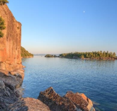
Daisy Lake sits quietly in the forests of Northeastern Ontario, offering hikers a genuine escape into the region's characteristic landscape of dense woodlands and rolling terrain. This 3.2-kilometer moderate trail with 300 meters of elevation gain takes roughly an hour and twenty minutes to complete, making it a solid half-day adventure for anyone looking to experience the natural beauty that defines this part of Ontario.
The lake itself is the centerpiece of the whole experience — its clear waters reflecting the surrounding canopy of mixed forest, changing character dramatically with the seasons. What makes Daisy Lake appealing is that balance between accessibility and authenticity: you can get here by car, but once you're on the trail, it genuinely feels like you've left everything behind.
Trail Experience and Terrain
The main route at Daisy Lake delivers a well-rounded moderate challenge. The 300 meters of elevation gain don't come at you all at once — they're spread across the 3.2 kilometers in a way that keeps things interesting without turning into a grind. You'll work your way through rolling terrain that's typical of this part of Ontario, with a mix of forested climbs and more open stretches that reward the effort with solid views.
The tougher sections push you up through rugged ground where the geological character of the landscape becomes more apparent — exposed rock, uneven footing, the kind of terrain that reminds you you're actually in the Canadian Shield country. These stretches are where proper footwear earns its keep. Trekking poles are worth considering if you're not used to that kind of surface.
The gentler portions of the trail follow closer to the lakeshore, where the pace naturally slows and the scenery shifts from forest interior to open water views. These lakeside stretches are natural spots to catch your breath, take photos, or just stand still for a minute and take it all in. The contrast between the forested climbs and the quieter lakeshore sections gives the hike a satisfying rhythm.
Wildlife and Natural Features
The mixed forest around Daisy Lake — conifers blending with deciduous trees — creates the kind of layered habitat that supports a good variety of wildlife. The combination of forest cover and proximity to water is particularly productive for birdwatching. Early morning and late afternoon are your best windows for wildlife activity, when things are moving and the light is better anyway.
The lake's water clarity is one of its standout features. It's the kind of clear you notice immediately, fed by the surrounding watershed and kept clean by the relatively undisturbed forest around it. That clarity makes it worth pausing at the water's edge just to watch the light play across the surface, especially on a calm morning.
Wildflowers show up along the trail edges and in the forest understory through the growing season, adding color that shifts as different species come and go from spring through fall. It's one of those details that makes return visits feel fresh rather than repetitive.
Swimming and Time at the Lake
After working through the trail's elevation, the lake offers a genuinely welcome payoff. The clear water makes for good swimming during warmer months, and it's the kind of spot where you'll want to factor in extra time rather than rushing back to the car right after finishing the loop. Find a flat rock at the water's edge, eat your lunch, let the legs recover — that's the natural rhythm of a day at Daisy Lake.
Camping and Extended Stays
For those who want more than a day trip, nearby camping options open up the experience considerably. Staying overnight changes the whole dynamic — you get the lake at dusk, the sounds of the forest after dark, and the early morning light on the water before anyone else shows up. The 3.2-kilometer trail is manageable enough that you could hike it more than once over a weekend stay and still find it worthwhile.
Planning Your Visit
Daisy Lake is accessible by car, which matters in Northeastern Ontario where distances between destinations can be significant. The moderate difficulty and roughly 1h20 duration make it a realistic standalone day trip, though the camping option means you can easily build it into a longer itinerary exploring this part of the province.
Come prepared with water, snacks, and layers — Northeastern Ontario weather can shift quickly, and the trail's mix of exposed terrain and shaded forest means conditions can feel different depending on where you are on the route. Solid hiking footwear is worth it given the uneven ground on the more elevated sections. Let someone know your plans and expected return time, especially if you're heading out on a quieter weekday when you may not cross paths with many other hikers.
Recommended gear for this trail


Ready to go?
Everything you need to know before you goStarting Point
The daisy lake trails are located in the town of Bancroft, Ontario. To get to the start of the trails, take Highway 28 east out of Bancroft for about 5 km until you reach the daisy lake Provincial Park entrance on the left.
When?
How much?
- Hiking shoes Essential
- → Salomon Elixir Tour Mid WP · 203.38 $
- Layered clothing Essential
- Rain jacket Essential
- Trekking poles
- → Black Diamond Trail Ergo Cork · 69.99 $
- Headlamp
- → Petzl Actik Core 625 · 103.95 $
FAQ - Frequently asked questions
Everything you need to knowThe Essential Hiking Checklist
Everything you need for your next hike. Bilingual, printable, 1 page.
Download the free checklistSimilar hikes nearby
Discover other trails you might enjoy

Wolf Lake Mountain, Ontario
Northeastern Ontario
Mount Ararat
Northeastern Ontario
Ghost Range
Northeastern Ontario
Halfway Lake Provincial Park
Northeastern Ontario
Cedar Falls
Northeastern Ontario
Lake Superior Provincial Park
Northeastern Ontario
Hiking near Barrie
146 trails to explore ~248 km away
We work hard to provide the most up-to-date and error-free data possible. If something seems incorrect, let us know! Your contribution helps the whole community.
Hikers' opinions