

Ready to explore Excursion À L'île Saint-barnabé? Here's everything you need to know before you go!
Discover the trail

Trail description
Description
Excursion À L'île Saint-Barnabé is a quiet, nature-focused outing in the Bas-Saint-Laurent region, set on Île Saint-Barnabé in the St. Lawrence River. The appeal here is simple: you take a short ferry ride from Rimouski, step onto the island, and spend your day walking through shoreline views, forested stretches, and pockets of history—all without needing to commit to steep climbs or technical terrain.
What the hike feels like
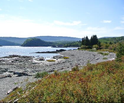
Once you’re on Île Saint-Barnabé, the experience is built around variety rather than intensity. The island has over 20 kilometers of well-maintained, clearly marked trails, so you can choose your own pace and route depending on how much time and energy you have. You’ll find options that suit everything from a relaxed shoreline walk to a longer ramble that takes you deeper into lush forest.
The terrain is described as approachable, which makes it a comfortable choice if you’re easing into hiking, heading out with mixed-ability companions, or simply looking for a low-stress day outdoors. Expect a mix of open views and more sheltered sections where the trees close in and the wind drops away. The island setting makes the scenery feel close and immersive—water on the edges, forest in the interior, and frequent chances to pause and take in the river.
Trail network and route options
Because there are more than 20 kilometers of trails, this outing works well if you like flexible plans. You can keep it short and straightforward by sticking near the shoreline, or you can link sections together for a longer day on foot. The trail system is clearly marked, which takes a lot of the guesswork out of navigating and makes it easier to adjust your route on the fly.
If you’re the type who likes to explore, this is a good place to wander without feeling boxed into a single “one way in, one way out” trail. If you prefer structure, the signage and maintained paths still keep things simple—pick a direction, follow the markers, and enjoy the views as they open up along the St. Lawrence River.
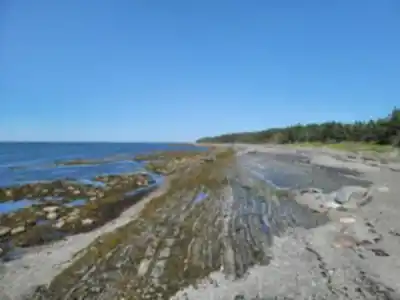
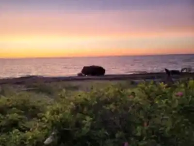
Scenery: St. Lawrence River viewpoints and island landscapes
The standout feature is how often the St. Lawrence River is part of the experience. Even when you’re not directly on the shoreline, the trails give you frequent glimpses of the surrounding landscapes, with viewpoints that remind you you’re hiking on an island rather than on the mainland. Along the water, the walking feels more open and breezy; in the forest, it becomes quieter and more enclosed, with the sense of being tucked away from the city.
Bring your camera. The island is described as full of picture-perfect moments, and that’s easy to believe here: changing angles on the river, forest textures, and the overall contrast between water and woodland.
Nature and wildlife to watch for
Île Saint-Barnabé is a good spot for hikers who like to keep their eyes moving as they walk. The island’s diverse ecosystems support a mix of wildlife, and the experience is often about noticing small changes from one section of trail to the next—different plant communities, different bird activity, and shifting light under the trees.
Wildlife you may encounter includes white-tailed deer and foxes, along with a variety of bird species. The plant life is part of the draw too: vibrant wildflowers and towering trees create a calm, restorative feel, especially if you’re looking to slow down and spend a few hours focused on the outdoors rather than the clock.
History along the way
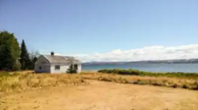
This outing isn’t only about nature. Île Saint-Barnabé is also presented as a place with deep roots, and you’ll see that as you explore. The island was named after Barnabas Collins, an early settler, and it has served as a place of refuge and inspiration for centuries.
As you hike, you’ll come across remnants of past settlements. Informative signage along the trails helps put what you’re seeing into context, so you’re not just passing by historic traces without realizing what they represent. It’s the kind of detail that adds interest to a walk—especially if you enjoy destinations that feel layered, where the landscape has stories as well as scenery.
Getting there: ferry access from Rimouski
Access is part of the experience here. To reach Île Saint-Barnabé, you’ll take a short ferry ride from Rimouski. That quick crossing helps the day feel like a true “excursion,” even if you’re not hiking anything extreme. It also means you’ll want to think about timing: arrive with enough cushion to make the ferry without rushing, and plan your island time around that return trip so you’re not watching the clock the whole day.
On-island facilities and breaks
Once on the island, you’ll find picnic areas—an easy way to build a relaxed break into your route. Packing a lunch works well here because you can choose a scenic spot, take your time, and then keep walking without needing to leave the trail network. The setting is ideal for a mid-hike pause: water views nearby, forest shade when you want it, and the sense of being away from busy roads.
What to bring
This is a hiking-focused destination, so start with comfortable footwear you can walk in for several hours. Even though the trails are described as well maintained and suitable for all levels, you’ll enjoy the day more if your shoes handle a mix of packed trail and natural surfaces. A daypack with water and a packed lunch fits the island style, especially if you plan to use the picnic areas.
A camera is worth making room for, since the island offers frequent photo opportunities—river views, forest scenes, wildlife sightings, and historical elements along the route.
Who this hike is good for
Because the trail network includes options for all levels of hiking experience, this is a practical choice for a wide range of visitors: hikers who want an easy day, people who prefer strolling along the shoreline, and anyone who wants a calmer outing that still feels like a real escape. It also works well if your group has different interests—some can focus on wildlife watching, others on views, and others on the island’s history and signage.
How to plan your day on the trails
A good approach is to decide what you want most from the visit, then shape your walking around that. If your priority is scenery, spend more time near the shoreline where the St. Lawrence River stays in view and the landscape feels open. If you want a quieter, more immersive nature walk, head into the forested sections where the trees, wildflowers, and bird activity become the main focus. If you’re interested in the island’s past, slow down when you reach the informative signage and keep an eye out for remnants of earlier settlements as you move along the marked trails.
With a clearly marked, well-maintained network and plenty of distance available, you can keep things flexible: start easy, see how everyone feels, and add more trail time if the day is going well.
Recommended gear for this trail


Ready to go?
Everything you need to know before you goStarting Point
To access the hiking trails, head to the ferry terminal located at 199 Rue du Parc, Rimouski, QC G5L 7C3. The ferry will take you to the island where the trails begin. There are no alternative trailheads; all visitors must use this ferry service to reach the starting point of the trails.
When?
How much?
- Hiking shoes Essential
- → Salomon Elixir Tour Mid WP · 203.38 $
- Layered clothing Essential
- Rain jacket Essential
- Trekking poles
- → Black Diamond Trail Ergo Cork · 69.99 $
- Headlamp
- → Petzl Actik Core 625 · 103.95 $
FAQ - Frequently asked questions
Everything you need to knowThe Essential Hiking Checklist
Everything you need for your next hike. Bilingual, printable, 1 page.
Download the free checklistSimilar hikes nearby
Discover other trails you might enjoy
Parc National Du Bic
Bas-Saint-Laurent
Parc du Mont-Saint-Mathieu
Bas-Saint-Laurent
Canyon Des Portes De L'enfer
Bas-Saint-Laurent

Beausejour Park
Bas-Saint-Laurent
Parc Des Chutes
Bas-Saint-Laurent

Lac Anna
Bas-Saint-Laurent
Hiking near Quebec City
40 trails to explore ~271 km away
We work hard to provide the most up-to-date and error-free data possible. If something seems incorrect, let us know! Your contribution helps the whole community.
Hikers' opinions