

Ready to explore Île Aux Lièvres? Here's everything you need to know before you go!
Discover the trail


Trail description
Description
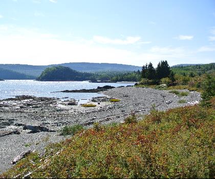
Île aux Lièvres, in the Bas-Saint-Laurent region, is the kind of place you visit when you want your hike to feel like a real escape. Because it’s an island set in the St. Lawrence River, the experience is shaped as much by water and sky as it is by the trail under your feet. From the moment you arrive, you’re surrounded by changing views—forest edges opening to shoreline, open stretches where the wind comes in off the river, and long looks across the water that make the whole day feel bigger than the mileage.
What the hike feels like
Hiking on Île aux Lièvres is about variety. The island has a network of well-maintained hiking trails with terrain that shifts often enough to keep things interesting without feeling technical. You’ll move through lush forests where the light filters through the canopy, then step out into open meadows that feel airy and quiet, then find yourself following sections of rugged coastline where the land meets the St. Lawrence in a more dramatic way.
The route options are described as suitable for all levels of experience, so it works whether you’re looking for a relaxed day outside or you want to spend longer exploring the island’s different corners. Even on easier terrain, you still get that “away from it all” feel because you’re not hiking beside a road or through a developed area—you’re moving through landscapes that feel distinctly natural and coastal.
Distance and difficulty
The Île Aux Lièvres trail network totals 36.6 km and is rated easy, with about 40 m of elevation gain. That combination usually translates to a trip where the effort comes more from time on your feet and the changing surfaces than from steep climbs. Plan for a pace that lets you stop often—this is a place where the scenery and wildlife sightings can naturally slow you down in the best way.
Landscapes you’ll move through
The island’s main draw is how quickly the scenery changes. In the forest, the trail feels sheltered and calm, with a sense of being tucked into the island’s interior. The meadows add contrast—more open space, more sky, and a different kind of quiet. Along the coastline, you’ll notice the shift in mood: the ground feels more rugged, the views open up, and the St. Lawrence becomes the constant backdrop.
If you like hikes where you can point out “new” scenery every hour—woods, open stretches, then shoreline—this is exactly that kind of day. It’s also a great setting for anyone who enjoys photographing landscapes, because the mix of textures (forest greens, meadow openness, and rocky edges by the water) gives you variety without needing to travel far.
Wildlife and what to watch for
One of the highlights of hiking on Île aux Lièvres is the chance to see wildlife as part of the day, not as a rare bonus. Along the shore, keep an eye out for seals basking on the rocks. Above you, you may spot seabirds soaring overhead, especially when you’re in more open areas or near the coastline where there’s a clear view of the sky and water.
And yes, there’s always the possibility of seeing the island’s namesake: hares moving quickly through the underbrush. They’re the kind of animals you often notice in a flash—something darting between cover—so it pays to walk quietly in the forested sections and scan the edges of the trail rather than only looking ahead.
The island is also described as home to a variety of plant species, which adds another layer to the walk. If you enjoy slowing down to notice what’s growing at the trail edge, or if you like taking close-up nature photos as much as big landscape shots, you’ll have plenty to work with.
Views of the St. Lawrence River
Because the island sits in the St. Lawrence, breathtaking views of the St. Lawrence River are a constant theme. Even when you’re in the trees, you’re never far from the sense that water is nearby. Once you reach more exposed sections—especially along the coast—you’ll get wide, open looks across the river that make you want to stop, take a breath, and just watch what’s happening on the water and in the sky.
These viewpoints are also where the island’s atmosphere really comes through: the feeling of being on the edge of land, the sound of waves, and the changing light that can make the same stretch of shoreline look completely different from one hour to the next.
Staying overnight
If you don’t want the experience to end when the day hike is over, Île aux Lièvres offers rustic accommodations that let you stay right in the middle of this natural setting. The appeal here isn’t luxury—it’s the chance to stretch the trip into an evening and morning on the island, when things feel even quieter and more removed from everyday routines.
After a day on the trails, evenings are for simple, memorable moments: stargazing under clear skies and listening to the gentle lapping of waves against the shore. If you’re the type of person who likes to wake up where you hike—step outside and feel like you’re already “there”—this is the kind of place where an overnight stay adds a lot to the overall experience without needing a packed itinerary.
Who it’s a good fit for
Île aux Lièvres works well for a wide range of hikers because the trails cater to all levels of experience. Newer hikers can enjoy the easy difficulty and well-maintained paths while still getting big scenery and wildlife potential. More experienced hikers will appreciate the sheer amount of trail to explore, the variety in terrain, and the island setting that makes even an easy walk feel special.
It’s also a strong choice if you’re torn between seeking solitude and wanting a bit of adventure. The island environment naturally delivers both: there’s a quiet, tucked-away feel in the interior sections, and a more dramatic, open feeling along the rugged shoreline.
Trail experience and pacing
Because the island offers a network of trails rather than a single short out-and-back, it’s worth approaching the day with a flexible mindset. Let the terrain guide your pace: move steadily through the forest, slow down when the meadow opens up, and give yourself extra time along the coastline where the views and wildlife often create natural stopping points.
The best moments here tend to come when you’re not rushing—when you’re paying attention to what’s happening around you, scanning the rocks for seals, looking up at seabirds, and watching for quick movement in the brush that could be a hare. The island is a place where the “in-between” moments—pausing to look across the St. Lawrence, listening to the waves—feel like part of the hike, not interruptions.
Recommended gear for this trail


Ready to go?
Everything you need to know before you goStarting Point
To access the hiking trails, you need to take a ferry from Rivière-du-Loup. The ferry terminal is located at 199 Rue Hayward, Rivière-du-Loup, QC G5R 3Y8. Once you arrive on the island, there are several trailheads accessible from the main dock area.
When?
How much?
- Hiking shoes Essential
- → Salomon Elixir Tour Mid WP · 203.38 $
- Layered clothing Essential
- Rain jacket Essential
- Trekking poles
- → Black Diamond Trail Ergo Cork · 69.99 $
- Headlamp
- → Petzl Actik Core 625 · 103.95 $
FAQ - Frequently asked questions
Everything you need to knowThe Essential Hiking Checklist
Everything you need for your next hike. Bilingual, printable, 1 page.
Download the free checklistSimilar hikes nearby
Discover other trails you might enjoy
Parc National Du Bic
Bas-Saint-Laurent
Parc du Mont-Saint-Mathieu
Bas-Saint-Laurent

Canyon Des Portes De L'enfer
Bas-Saint-Laurent

Beausejour Park
Bas-Saint-Laurent
Parc Des Chutes
Bas-Saint-Laurent

Lac Anna
Bas-Saint-Laurent
Hiking near Quebec City
40 trails to explore ~160 km away
We work hard to provide the most up-to-date and error-free data possible. If something seems incorrect, let us know! Your contribution helps the whole community.
Hikers' opinions