

Ready to explore Parc Linéaire Interprovincial Le Petit Témis? Here's everything you need to know before you go!
Discover the trail
Oh no! We don't have any photos 😢
This trail hasn't been captured yet. Be the first to share your adventure!Trail description
Description
Parc Linéaire Interprovincial Le Petit Témis is a long, scenic linear park in the Bas-Saint-Laurent region where you can spend a few hours in the woods or turn your outing into a point-to-point adventure. The route follows a former railway line that has been converted into a multi-use trail, creating a steady, easygoing corridor through forests, along waterways, and past a mix of natural and cultural touchpoints. It links Rivière-du-Loup in Quebec with Edmundston in New Brunswick, so it’s a trail that genuinely feels like travel—one continuous ribbon of trail connecting communities across provinces.
Trail overview and route character
The trail stretches over 134 kilometres end to end, offering an experience that can be approached in small segments or as an ambitious multi-day trek. Because it’s built on a former rail bed, the corridor generally feels wide and predictable underfoot, with a “rail-trail” style layout that encourages steady pacing rather than constant route-finding. The park is described as well-maintained and marked, which makes it approachable for first-timers and also useful for experienced hikers who want a straightforward line to follow while focusing on distance and scenery.
In practical terms, you can expect a linear trail experience: you’re moving through a sequence of landscapes rather than looping back to where you started. That changes how the day feels—you’re always arriving somewhere new—and it’s part of what makes Le Petit Témis stand out in Bas-Saint-Laurent. If you like hikes where the scenery evolves gradually and you can settle into a rhythm, this is the kind of route that rewards time on your feet.
Landscape: forests, lakes, and rivers
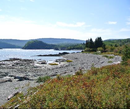
As you make your way along Le Petit Témis, the setting shifts between lush forests, serene lakes, and picturesque rivers. The forested stretches give you that classic Bas-Saint-Laurent feeling of being surrounded by greenery and quiet, with the trail acting like a gentle corridor through the trees. When the route opens toward water, the mood changes—sightlines get longer, light reflects off the surface, and the walk becomes more about taking in the view than watching your footing.
The mix of forests and waterways also gives the trail a calming, “unplugged” feel. Even when you’re covering distance, the environment invites you to slow down: stop for a few minutes, listen for birds, and let the sound of moving water or wind in the trees fill in the background. This variety is a big part of why the trail works for different types of outings—whether you want a leisurely stroll with lots of pauses or a longer day where you’re steadily moving forward.
Lake Témiscouata viewpoints
One of the signature highlights along the route is its proximity to Lake Témiscouata. Walking near the lake brings a different scale to the experience: wider horizons, big sky, and a shoreline atmosphere that’s noticeably distinct from the enclosed feel of the forest. If you’re the kind of hiker who likes to build in “view breaks,” this is a natural place to pause—take in the scenery, stretch, drink some water, and enjoy how the trail brings you right into contact with a major landscape feature of the region.
Because the trail follows a former railway alignment, the lakeside sections tend to feel like you’re traveling alongside the water rather than scrambling down to it. The result is a comfortable, steady walk where the view stays with you for a while instead of appearing for a quick moment and disappearing again.
Wildlife watching along the corridor
Le Petit Témis is also a good place to keep your eyes up and your pace flexible, since there are regular opportunities to spot wildlife. The corridor passes through habitats where you might see deer, beavers, or even a bald eagle overhead. The best approach is to stay quiet in the forested stretches and scan water edges and open areas near lakes and rivers—beavers are often associated with waterways, and eagles are easier to spot when you have a broader view of the sky.
Even if you don’t see animals directly, the trail’s mix of forest and water makes it feel “alive” in a way that adds to the experience: tracks, movement in the trees, and the occasional sound from the shoreline can make the walk feel like more than just covering ground.
History and interpretive panels
Part of what makes this trail more than a simple greenway is the way it weaves in local history. Along the route, you’ll find interpretive panels that provide context about the region’s Indigenous heritage and the importance of the corridor as a former railway line that helped connect communities across provincial boundaries. These short stops are easy to integrate into a day on the trail: you can treat them as built-in breaks where you catch your breath, learn something, and then continue on with a better sense of where you are and how people have moved through this landscape over time.
That “transportation history” feeling is still present even though the railway is gone. The long, continuous alignment and the way it links towns and regions makes the trail feel purposeful—like you’re following a route that has mattered for generations, just at a human pace instead of by train.
Who this trail works for
The park is described as accessible for hikers of all levels, and the overall experience supports that. If you want a simple, low-stress outing, you can pick a section and enjoy a straightforward walk with consistent navigation thanks to the maintained and marked trail. If you’re looking for something more demanding in terms of endurance rather than technical difficulty, the full length invites longer efforts and multi-day planning, with the added satisfaction of moving between Rivière-du-Loup and Edmundston along a single corridor.
It’s also a good fit for hikers who like linear trails because they feel like a journey. Instead of circling back, you’re progressing through Bas-Saint-Laurent landscapes and experiencing how forests, lakes, and rivers fit together across a long distance.
What the hike feels like on the ground
On a trail like this, the experience is less about big climbs and more about steady forward motion and changing scenery. You’ll spend stretches in the shelter of trees, then transition toward open water and wider views, then return to forest again. Because the trail is described as well-maintained and well-marked, you can focus on pacing, taking photos, and stopping where the scenery pulls you in—especially near Lake Témiscouata and along the rivers.
If you’re planning a longer day, it helps to think in terms of sections: forest corridors for steady walking, lakeside moments for longer pauses, and interpretive panels as natural checkpoints. For shorter outings, you can aim for a simple “out-and-back” feel on a portion of the trail, letting the water and forest provide the variety without needing to commit to big mileage.
Why it stands out in Bas-Saint-Laurent
Bas-Saint-Laurent is known for nature that feels both expansive and intimate, and Le Petit Témis captures that balance. Over the course of the trail, you’re moving through quiet forest, then right alongside significant bodies of water, with the added layer of a cross-province connection that gives the route a distinct identity. The combination of a repurposed railway corridor, long-distance continuity, marked navigation, and the chance to pair scenery with cultural interpretation makes it feel like a true regional route rather than a single isolated hike.
If you’re the type of outdoor enthusiast who likes routes that can grow with you—start with a relaxed stroll, return for longer sections, and eventually tackle a bigger point-to-point trip—this linear park naturally supports that kind of progression while keeping the experience rooted in the landscapes of Bas-Saint-Laurent and the shores of Lake Témiscouata.
Recommended gear for this trail


Ready to go?
Everything you need to know before you goStarting Point
To access the hiking trails, you can start at several trailheads. One option is to begin at the parking lot located at 100 Rue Saint-Louis, Rivière-du-Loup, QC G5R 2X8. Another starting point is at the parking area near 1 Rue de la Gare, Cabano, QC G0L 1E0. Both locations provide convenient access to the trails.
When?
How much?
- Hiking shoes Essential
- → Salomon Elixir Tour Mid WP · 203.38 $
- Layered clothing Essential
- Rain jacket Essential
- Trekking poles
- → Black Diamond Trail Ergo Cork · 69.99 $
- Headlamp
- → Petzl Actik Core 625 · 103.95 $
FAQ - Frequently asked questions
Everything you need to knowThe Essential Hiking Checklist
Everything you need for your next hike. Bilingual, printable, 1 page.
Download the free checklistSimilar hikes nearby
Discover other trails you might enjoy
Parc National Du Bic
Bas-Saint-Laurent
Parc du Mont-Saint-Mathieu
Bas-Saint-Laurent
Canyon Des Portes De L'enfer
Bas-Saint-Laurent

Beausejour Park
Bas-Saint-Laurent
Parc Des Chutes
Bas-Saint-Laurent

Lac Anna
Bas-Saint-Laurent
Hiking near Quebec City
40 trails to explore ~188 km away
We work hard to provide the most up-to-date and error-free data possible. If something seems incorrect, let us know! Your contribution helps the whole community.
Hikers' opinions