

Ready to explore Parc National Du Lac-témiscouata? Here's everything you need to know before you go!
Discover the trail
Oh no! We don't have any photos 😢
This trail hasn't been captured yet. Be the first to share your adventure!Trail description
Description
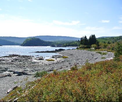
Parc National du Lac-Témiscouata sits in the Bas-Saint-Laurent region and feels like the kind of place you stumble onto and immediately want to slow down. It’s a quiet, nature-first park built around big water, deep forest, and the sort of views that remind you how much space there is out here when you get away from towns and highways.
Covering more than 175 square kilometers, the park protects a broad mix of landscapes: dense, pristine forest, bright open shorelines, and a lake that constantly pulls your attention back to it. The setting is classic Bas-Saint-Laurent—green and rugged without feeling harsh—so you can plan anything from a calm day outside to a full weekend of moving through different corners of the park.
Hiking: what the trails feel like
The park’s hiking network is one of its biggest draws, and it works well whether you’re looking for a gentle outing or something that makes you earn the scenery. Expect forest walking as a theme: shaded stretches under thick canopy, a quieter feel as you move away from the lake, and frequent moments where the trees open up just enough to give you a sense of how big the landscape is.
If you’re chasing views, the Montagne-du-Fourneau trail is the one that’s specifically called out for its panoramic lookouts. This is the kind of hike where you spend a lot of the day in the woods, and then the payoff arrives when you reach open vantage points and suddenly see the broader Bas-Saint-Laurent terrain around Lac Témiscouata. It’s a good option when you want a “destination” moment rather than just a forest walk.
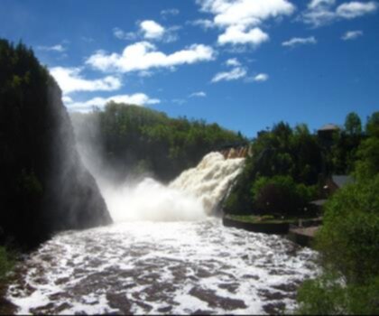
If you prefer a hike with a clear natural feature at the end, the Sutherland Falls trail takes you through lush forest to a waterfall. The route itself is part of the experience—cooler air under the trees, the sense of gradually heading toward moving water, and that shift in sound and humidity as you get closer. It’s an easy trail to build a day around because the waterfall gives you a natural turnaround point and a reason to linger before heading back.
Landscape and wildlife
Even without focusing on any single “must-see,” the park stands out for the variety you can experience in one visit. The forests here are described as pristine, which matches the overall feel of the place: long stretches where the scenery is simply trees, terrain, and silence broken by birds and wind. That quiet also makes it easier to notice wildlife. The park is known for its diverse wildlife, so keep your pace relaxed and your eyes up—especially along quieter sections of trail where you’re less likely to meet other visitors.
Along the way, the constant presence of sparkling lakes (and especially Lac Témiscouata) changes the mood of the park. You can go from enclosed forest to open shoreline quickly, and those shifts keep even easier hikes from feeling repetitive.
Water time on Lake Témiscouata
Lake Témiscouata is the heart of the park and the obvious place to spend time if you like being on the water. It’s described as a vast body of water, and it supports a full range of low-stress to active days: kayaking and canoeing are both popular here, and it’s equally suited to simply claiming a spot by the shore and settling in for a peaceful break between hikes.
Fishing is also a draw, with opportunities to catch lake trout and smallmouth bass. This is the kind of lake where fishing can fit naturally into your day—early morning near shore, a mid-day break after a hike, or an evening session if you’re staying overnight. If you’re mixing activities, it’s easy to plan a trip where hiking gives you the big views or the waterfall, and the lake gives you the slower rhythm afterward.
History and culture on the landscape
Parc National du Lac-Témiscouata isn’t only about scenery and outdoor activities. The park includes several archaeological sites that connect today’s trails and shorelines to the people who lived and traveled here long before modern recreation. These sites provide insight into the heritage of the First Nations who once inhabited this area, and they add a deeper layer to a visit—especially if you like to understand how a landscape was used, not just what it looks like.
The Témiscouata Portage Trail is particularly significant. It was historically used by Indigenous peoples and later by European settlers, which makes it more than a path through the woods—it’s a route that reflects how people moved across this region over time. Hiking it can feel different than a typical park trail because you’re following a corridor of travel that existed long before the park did.
Camping: staying long enough to settle in
If you want more than a day trip, camping is available inside the park, and the options range from rustic campsites to more equipped stays. That flexibility makes it easier to match your trip to your style: go simple and quiet if you’re mainly here to hike, or choose a more equipped option if you’re bringing extra gear for the lake or prefer a bit more structure at camp.
Camping also changes how the park feels. Day visitors often focus on one feature—like a viewpoint or a waterfall—while an overnight stay lets you move at a slower pace: a morning hike before the day warms up, time on the water in the afternoon, and then an evening back at camp when the forest gets quiet again.
How to plan your time here
This park works well for a wide range of outdoor days, and it’s especially good if you like mixing activities. A common approach is to choose one hike built around a highlight—either the Montagne-du-Fourneau panorama or the forest-and-waterfall experience of Sutherland Falls—and then keep the rest of your time open for the lake. The contrast is what makes it feel like a full trip: elevated viewpoints and forest trails on one side, then open water and shoreline calm on the other.
Even if you keep things simple, you’ll still get a strong sense of place here. Between the park’s forests, the scale of Lake Témiscouata, and the cultural layer added by the archaeological sites and the historic portage route, it’s a landscape that offers more than just a single “photo spot” and rewards visitors who take their time.
Recommended gear for this trail


Ready to go?
Everything you need to know before you goStarting Point
To access the hiking trails, you can start at one of several trailheads. The main entry point is located at 400 Chemin de la Vieille-Route, Saint-Michel-du-Squatec, QC G0L 3J0. Another option is to begin your hike from the parking area at 120 Chemin du Lac, Squatec, QC G0L 4H0. Both locations provide convenient access to the trail network.
When?
How much?
- Hiking shoes Essential
- → Salomon Elixir Tour Mid WP · 203.38 $
- Layered clothing Essential
- Rain jacket Essential
- Trekking poles
- → Black Diamond Trail Ergo Cork · 69.99 $
- Headlamp
- → Petzl Actik Core 625 · 103.95 $
FAQ - Frequently asked questions
Everything you need to knowThe Essential Hiking Checklist
Everything you need for your next hike. Bilingual, printable, 1 page.
Download the free checklistSimilar hikes nearby
Discover other trails you might enjoy
Parc National Du Bic
Bas-Saint-Laurent
Parc du Mont-Saint-Mathieu
Bas-Saint-Laurent
Canyon Des Portes De L'enfer
Bas-Saint-Laurent

Beausejour Park
Bas-Saint-Laurent
Parc Des Chutes
Bas-Saint-Laurent

Lac Anna
Bas-Saint-Laurent
Hiking near Quebec City
40 trails to explore ~215 km away
We work hard to provide the most up-to-date and error-free data possible. If something seems incorrect, let us know! Your contribution helps the whole community.
Hikers' opinions