

Ready to explore Sentiers Du Littoral Et De La Rivière Rimouski? Here's everything you need to know before you go!
Discover the trail


Trail description
Description
The Sentiers Du Littoral Et De La Rivière Rimouski are a quieter option for getting outside in the Bas-Saint-Laurent, with routes that put you close to the water and into a mix of coastal and river-side ecosystems. If you’re looking for a place to walk, hike, watch birds, or just spend a few hours in nature without needing a big expedition, this network makes it easy to tailor your outing to the time and energy you have.
What the hike feels like
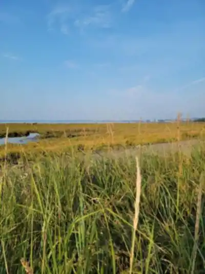
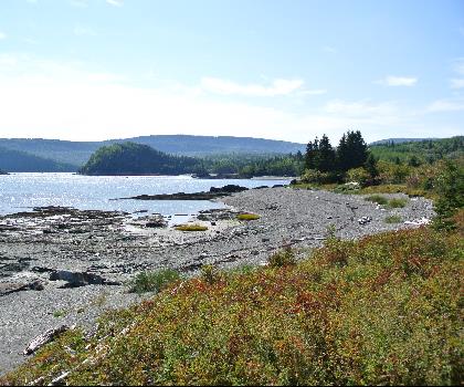
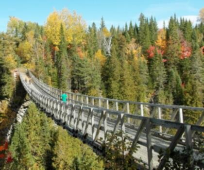
These are well-maintained trails that let you move between two main “moods” of scenery: open views toward the St. Lawrence River and greener, more sheltered sections where the vegetation closes in around you. Expect plenty of natural variety along the way—one moment you’re looking out at wide water and sky, and the next you’re walking through lush greenery with a more intimate, calm feel.
Because the trails are designed for all levels of hikers, the experience can be as relaxed or as ambitious as you make it. Beginners can stick to shorter, easy-going sections for a leisurely stroll, while more experienced hikers can link segments together for a longer outing. If you want a simple, straightforward goal for the day, the trail network totals 15.1 km with a gentle 20 m of elevation gain, which keeps the focus on scenery and time outside rather than big climbs.
Landscapes and viewpoints
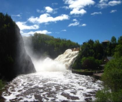
One of the reasons people come here is the way the landscape keeps opening up. As you hike, you’ll come across scenic viewpoints where it makes sense to pause, catch your breath, and take in what’s around you. The combination of coastal views and vibrant greenery is what gives this area its character—especially on days when the light changes quickly over the water and the shoreline looks different every few minutes.
These lookout-style moments are also where the trail feels most “Bas-Saint-Laurent”: big river views, fresh air, and that sense of being close to a living shoreline. Even if you’re not doing the full distance, it’s worth planning your walk around at least one viewpoint so you get the full payoff of being on these trails.
Wildlife and what to watch for
The biodiversity here is a real highlight, and you don’t need to be an expert naturalist to enjoy it. The area is home to a variety of bird species, and the best approach is simply to slow down in quieter sections and scan the edges of the trail, treetops, and open water. You may also spot other wildlife during your hike, so it’s worth keeping your eyes up and your pace relaxed—especially near viewpoints and along sections where the habitat feels more sheltered.
If birding is part of your plan, consider bringing binoculars and giving yourself extra time. Even without any gear, this is the kind of place where you’ll notice more when you stop for a minute and listen.
Trail features and learning on the go
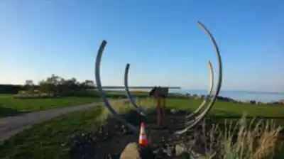
Along the route you’ll find informational panels that add context to what you’re seeing. They cover the local flora and fauna as well as the area’s geological history, turning a simple walk into something a bit more educational. These panels are especially useful if you’re visiting with kids, hiking with someone who likes to know “what that plant is,” or if you just enjoy having a better sense of how the landscape came to be.
Even if you’re keeping a steady walking rhythm, these are natural stopping points—small breaks that help pace out the hike and encourage you to look around rather than just watching your feet.
Picnicking and photography
The Sentiers Du Littoral Et De La Rivière Rimouski are a great fit if you want more than just movement. There are good opportunities for picnicking, especially if you plan to pause at one of the scenic viewpoints or in a pleasant stretch of greenery where you can settle in for a bit. Pack out whatever you bring, and aim for snacks that travel well so you can keep your visit simple and low-stress.
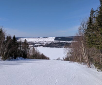
For anyone who likes taking photos, the variety is the draw: wide river views, textured greenery, and those moments where the landscape opens up unexpectedly. The trails can be especially rewarding for capturing the vibrant colors of autumn leaves or the quiet, minimalist feel of a serene winter landscape. If photography is a priority, give yourself time to stop often—these trails have plenty of “around the next corner” scenes, and the best shots usually happen when you’re not in a rush.
Planning tips: conditions, weather, and what to pack
Before heading out, it’s smart to check trail conditions and weather forecasts. With coastal and river-side environments, conditions can change quickly, and being prepared makes the whole outing more comfortable. Dress for the weather you’ll actually be walking in, not just what it looks like from the parking area, and consider bringing an extra layer if you expect wind near open viewpoints.
Carry the basics: water, snacks, and appropriate clothing for your journey. Even on an easy day, having enough water and a little food makes it easier to slow down, enjoy the viewpoints, and take your time with the interpretive panels instead of turning back early. Comfortable footwear matters too—since these are hiking trails, you’ll have a better day in shoes or boots you trust.
Choosing a route that fits your group
Because the trail system is set up to support different experience levels, it works well for mixed groups. If you’re hiking with beginners, focus on a shorter out-and-back to a viewpoint and build in time for stops. If you’re with more experienced hikers, link sections together to create a longer day that still feels relaxed thanks to the minimal elevation gain.
Either way, the best approach is to treat this as a place to explore rather than race through: take advantage of the viewpoints, read a panel or two, watch for birds, and plan at least one longer pause—either for a photo session or a picnic—so the day feels like a true visit instead of just a workout.
Recommended gear for this trail


Ready to go?
Everything you need to know before you goStarting Point
To access the hiking trails, you can start at one of several trailheads. The main parking lot is located at 1095 Boulevard Saint-Germain, Rimouski, QC G5L 8Y9. Another option is to begin at the trailhead near 300 Rue Saint-Germain Ouest, Rimouski, QC G5L 4B4. Both locations provide convenient access to the trails and are well-marked for visitors.
When?
How much?
- Hiking shoes Essential
- → Salomon Elixir Tour Mid WP · 203.38 $
- Layered clothing Essential
- Rain jacket Essential
- Trekking poles
- → Black Diamond Trail Ergo Cork · 69.99 $
- Headlamp
- → Petzl Actik Core 625 · 103.95 $
FAQ - Frequently asked questions
Everything you need to knowThe Essential Hiking Checklist
Everything you need for your next hike. Bilingual, printable, 1 page.
Download the free checklistSimilar hikes nearby
Discover other trails you might enjoy
Parc National Du Bic
Bas-Saint-Laurent
Parc du Mont-Saint-Mathieu
Bas-Saint-Laurent
Canyon Des Portes De L'enfer
Bas-Saint-Laurent

Beausejour Park
Bas-Saint-Laurent
Parc Des Chutes
Bas-Saint-Laurent

Lac Anna
Bas-Saint-Laurent
Hiking near Quebec City
40 trails to explore ~270 km away
We work hard to provide the most up-to-date and error-free data possible. If something seems incorrect, let us know! Your contribution helps the whole community.
Hikers' opinions