

Ready to explore Parc Du Mont Arthabaska? Here's everything you need to know before you go!
Discover the trail


Available trails
| Trails | Distance | Elevation | Duration | Difficulty | GPX |
|---|---|---|---|---|---|
| 9.7 km | 150 m | 2h30 | Beginner | ||
| 0.9 km | 100 m | 21min | Beginner |
Trail description
Description
Parc du mont Arthabaska is a quiet, easy-to-visit outdoor spot in the heart of Centre-du-Québec that works well for a simple nature break or a more purpose-driven hike. It’s the kind of place you can show up to for a low-key walk through the woods, but it also delivers a clear payoff if you’re aiming for a viewpoint and a little bit of effort.
What the park feels like on the trail
The park is best known for its network of well-maintained trails, and the overall experience is straightforward: you’re moving through forested sections, following clear paths, and gradually working your way toward higher ground. Some routes are gentle and suited to an easy outing, while others feel more like a true hike—still approachable, but with enough climb to make the summit feel earned.
Because there are multiple trails with different levels of challenge, the park works for a range of visitors. If you’re coming with a mixed group—some people who hike often and others who just want a calm walk—you can usually find a route that matches the pace and energy of the day.
Trail options and difficulty
Parc du mont Arthabaska has a diverse trail network designed for all skill levels, from gentle forest walks to more challenging hikes. If you’re looking for something uncomplicated, the easier paths let you settle into the scenery without focusing too much on footing or navigation. If you want more of a workout, choose one of the routes that climbs more directly toward the higher viewpoints.
One of the practical advantages here is that the trails are described as well maintained, which makes the outing feel safer and more relaxed. Instead of constantly watching for unclear turns, you can focus on the surroundings and the rhythm of the hike.
For those who like having a clear target for the day, the structured trail information for Parc Du Mont Arthabaska lists a distance of 10.5 km, an elevation gain of 150 m, and an overall easy difficulty. That combination typically suits a wide range of hikers, including people who are newer to hiking but still want a proper outing on foot.
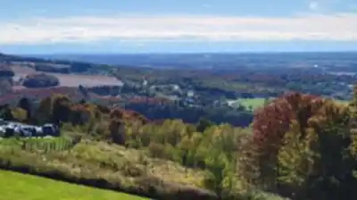
The summit and viewpoints
The big moment at parc du mont arthabaska is reaching the summit. This is where the park really stands out in Centre-du-Québec: you’re rewarded with panoramic views that stretch out across the surrounding countryside. It’s a classic “pause and take it in” spot—expect to linger, look around, and take photos with a wide-open backdrop that feels very different from the forested approach.
If you’re planning your timing, it helps to think of the summit as more than just a quick stop. The views are a key part of the experience, and it’s worth budgeting a few extra minutes to catch your breath, enjoy the scenery, and actually spend time up there before heading back down.
Other activities beyond hiking
Hiking is the main draw, but the park also supports other ways to get outside depending on the season. In warmer months, you can use the designated picnic areas, which makes it easy to turn a hike into an unhurried day out—walk first, then settle in for a meal with some space around you.
Mountain biking is also part of the warm-season mix, with trails described as specially designed for biking. If your group includes riders and hikers, this can be a flexible place to meet up and share the day, each choosing an activity that fits.
Winter use
When snow arrives, parc du mont arthabaska shifts into winter mode. The same landscape becomes a setting for cross-country skiing and snowshoeing, turning the trails into a different kind of outing—quieter, slower-paced, and often more about steady movement than chasing a summit view. If you enjoy visiting the same place in different seasons, this park lends itself well to repeat trips because the experience changes so much once everything is snow-covered.
Nature, wildlife, and what to watch for
The park emphasizes protecting its natural environment, and as you move through the trails you’ll be surrounded by the region’s flora. The forested sections are where the calm, “get away from it all” feeling really kicks in, especially if you keep your pace easy and take time to look around rather than just pushing for distance.
Wildlife sightings are part of the appeal too. As you walk, it’s worth keeping your attention up and scanning ahead and to the sides of the trail—you may spot local wildlife as you move through this tranquil setting. Staying observant (and a bit quieter) tends to make those moments more likely.
How to plan your visit
Parc du mont Arthabaska works well as a day trip, but it also fits naturally into a longer stay in Centre-du-Québec if you’re exploring the region. The park is set up for the kind of visit where you can keep things simple—comfortable walking shoes for the easier routes, hiking boots if you prefer more support on climbs, and enough time to enjoy the summit views without rushing.
Because the park supports multiple activities across the year—hiking, picnicking, mountain biking, cross-country skiing, and snowshoeing—you can plan around your preferred season and still get a solid outdoor experience each time you come. If your main goal is the panorama, prioritize a route that brings you to the summit and give yourself space in the schedule to actually enjoy the viewpoint once you’re there.
Services and amenities
This information may vary by season.
Recommended gear for this trail


Ready to go?
Everything you need to know before you goStarting Point
To access the hiking trails, head to the main parking lot located at 1000 Boulevard Arthabaska Est, Victoriaville, QC G6T 0S4. This is the primary starting point for most of the trails in the area.
When?
How much?
- Hiking shoes Essential
- → Salomon Elixir Tour Mid WP · 203.38 $
- Layered clothing Essential
- Rain jacket Essential
- Trekking poles
- → Black Diamond Trail Ergo Cork · 69.99 $
- Headlamp
- → Petzl Actik Core 625 · 103.95 $
FAQ - Frequently asked questions
Everything you need to knowThe Essential Hiking Checklist
Everything you need for your next hike. Bilingual, printable, 1 page.
Download the free checklistSimilar hikes nearby
Discover other trails you might enjoy

Réservoir Beaudet
Centre-du-Québec

Parc Régional De La Rivière Gentilly
Centre-du-Québec

Parc Marie-Victorin
Centre-du-Québec

Gleason
Centre-du-Québec

Sentier des Trotteurs
Centre-du-Québec

Sentier Les Pieds d'Or
Centre-du-Québec
Hiking near Sherbrooke
53 trails to explore ~70 km away
We work hard to provide the most up-to-date and error-free data possible. If something seems incorrect, let us know! Your contribution helps the whole community.
Hikers' opinions