

Ready to explore Parc national de la Yamaska? Here's everything you need to know before you go!
Discover the trail
Available trails
| Trails | Distance | Elevation | Duration | Difficulty | GPX |
|---|---|---|---|---|---|
| 5.8 km | 0 m | 1h30 | Beginner | ||
| 5.5 km | 0 m | 1h30 | Beginner | ||
| 10.3 km | 0 m | 2h30 | Beginner | ||
| 2.5 km | 0 m | 33min | Beginner | ||
| 19 km | 0 m | 4h30 | Intermediate |
Trail description
Description
Parc national de la Yamaska is one of those parks that tends to fly under the radar compared to the bigger names in Quebec's national park network — but that's honestly part of its charm. Located in the Estrie region, it offers a genuinely accessible outdoor experience without the crowds you'd find at more well-known destinations. Whether you're a local looking for a weekend escape or a visitor passing through the Eastern Townships, this park delivers a solid mix of trails, water, and wildlife in a compact, well-managed setting.
The Setting
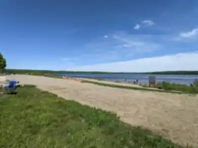
The park is built around the Choinière reservoir, a large body of water that shapes the entire feel of the place. A lot of the trails run along or near the shoreline, so you're rarely far from water. The landscape is a mix of deciduous forest, wetlands, and open areas that attract a wide variety of bird species — this is a genuinely good spot for birdwatching, especially during migration seasons. The terrain is relatively flat to gently rolling, which makes it welcoming for families, beginners, and anyone who wants to enjoy nature without a brutal climb.
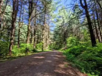
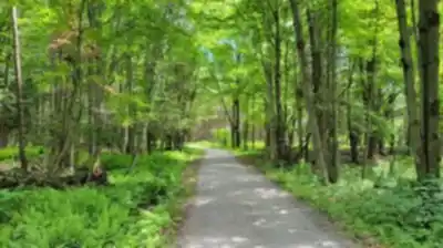
The forest here is predominantly made up of maple, birch, and other hardwoods typical of the Eastern Townships, which means fall colours can be spectacular. In summer, the tree cover keeps the trails shaded and comfortable even on warmer days.
Trail Network
The park has a network of hiking trails that wind through different ecosystems — from forested sections to open meadows and wetland edges. The paths are well-marked and maintained, so navigation is straightforward. Some trails bring you right to the water's edge, offering views across the reservoir that are hard to beat on a clear day.
Because the terrain is relatively gentle, most trails here are accessible to a wide range of hikers. That said, the park isn't just for casual walkers — if you string together multiple trails, you can put together a longer outing that still gives you a real sense of immersion in the landscape.
Beyond Hiking
Parc national de la Yamaska isn't exclusively a hiking destination. The park also offers access to the reservoir for swimming and non-motorized watercraft, making it a popular spot in summer for families who want to combine a trail walk with time on the water. There are designated beach areas and picnic spots, so it's easy to turn a hike into a full day out.
The park is managed by Sépaq (Société des établissements de plein air du Québec), which means the infrastructure is solid — clean facilities, good signage, and reliable trail maintenance year-round. Entry fees apply, consistent with other Sépaq parks, and it's worth checking their website for current rates and any reservation requirements, especially for peak summer weekends.
Wildlife and Nature
The diversity of habitats in the park — forest, wetland, open water, and meadow — creates good conditions for wildlife. Birdwatchers in particular will find plenty to look at, with waterfowl on the reservoir and songbirds throughout the forested sections. White-tailed deer are present in the park, and you may spot signs of beaver activity near the water. The wetland areas are especially rich in terms of biodiversity and worth slowing down for.
Practical Information
- Location: Estrie region, Quebec — easily reachable from the greater Montreal area and surrounding communities in the Eastern Townships.
- Managed by: Sépaq (Société des établissements de plein air du Québec)
- Entry fees: Standard Sépaq park fees apply. Check the official Sépaq website for current pricing and reservation options.
- Facilities: Parking, washrooms, picnic areas, beach access, and a visitor services area are available within the park.
- Dogs: Check current Sépaq guidelines for pet policies, as rules can vary by trail and season.
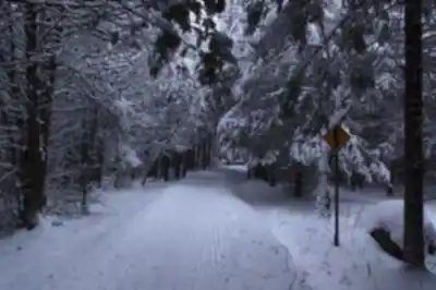
- Year-round access: The park is open in multiple seasons, with trails usable in winter for snowshoeing and cross-country skiing in addition to warm-weather hiking.
- Reservations: During peak periods, it's a good idea to book your entry in advance through the Sépaq reservation system to avoid being turned away at the gate.
What Makes It Worth the Trip
What sets Parc national de la Yamaska apart is the combination of easy access, genuine natural beauty, and a relaxed atmosphere. It's not a park that's going to challenge experienced mountain hikers looking for elevation gain and technical terrain — but that's not what it's trying to be. It's a place where you can spend a few hours or a full day moving through a varied landscape, watching birds, listening to the water, and actually unwinding. The reservoir is a real focal point, and trails that bring you to viewpoints over the water are consistently rewarding regardless of the season.
For families with kids, beginner hikers, or anyone who wants a nature experience that doesn't require a long drive or serious fitness preparation, this park checks a lot of boxes — and the quality of Sépaq's management means you can count on the basics being well taken care of when you show up.
Services and amenities
This information may vary by season.
Recommended gear for this trail


Ready to go?
Everything you need to know before you goStarting Point
To access the hiking trails, head to the main entrance of the park. The primary trailhead is located at 1780 Boulevard David-Bouchard, Roxton Pond, QC J0E 1Z0. There is a parking lot available at this address for visitors.
When?
How much?
- Hiking shoes Essential
- → Salomon Elixir Tour Mid WP · 203.38 $
- Layered clothing Essential
- Rain jacket Essential
- Trekking poles
- → Black Diamond Trail Ergo Cork · 69.99 $
- Headlamp
- → Petzl Actik Core 625 · 103.95 $
FAQ - Frequently asked questions
Everything you need to knowThe Essential Hiking Checklist
Everything you need for your next hike. Bilingual, printable, 1 page.
Download the free checklistSimilar hikes nearby
Discover other trails you might enjoy

Réservoir Beaudet
Centre-du-Québec

Parc Régional De La Rivière Gentilly
Centre-du-Québec

Parc Marie-Victorin
Centre-du-Québec

Gleason
Centre-du-Québec

Sentier des Trotteurs
Centre-du-Québec

Sentier Les Pieds d'Or
Centre-du-Québec
Hiking near Sherbrooke
53 trails to explore ~57 km away
We work hard to provide the most up-to-date and error-free data possible. If something seems incorrect, let us know! Your contribution helps the whole community.
Hikers' opinions