

Ready to explore Station touristique Duchesnay? Here's everything you need to know before you go!
Discover the trail


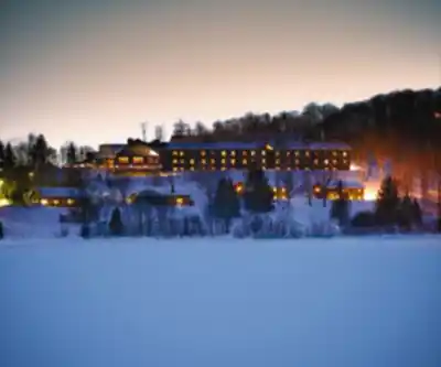
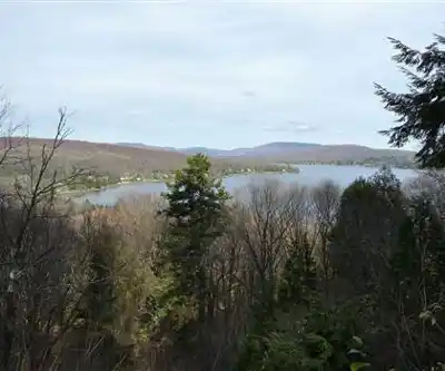
Available trails
| TrailTrails | Dist.Distance | GainElevation | Difficulty | GPX |
|---|---|---|---|---|
|
|
16.1 km | — | ||
|
|
1 km | — | ||
|
Beginner
|
1.3 km | — | Beginner | |
|
Beginner
|
3.3 km | — | Beginner | |
|
Beginner
|
1 km | — | Beginner | |
|
Beginner
|
6.1 km | — | Beginner | |
|
Beginner
|
5.2 km | — | Beginner | |
|
Beginner
|
3.5 km | — | Beginner | |
|
Beginner
|
0.4 km | — | Beginner | |
|
Beginner
|
5.2 km | — | Beginner | |
|
Beginner
|
1.7 km | — | Beginner |
Trail description
Station touristique Duchesnay is a Sépaq resort 30 minutes from Québec City, on the shore of Lac Saint-Joseph. The site covers 89 km². For walkers, Sépaq reports 25.7 km of hiking trails in gentle terrain, ideal for family walks. In winter the station also operates as a cross-country ski centre.
Routes on the official map
The official walking-trail map published by Sépaq gives the distance and time of each route. Times are estimated at an average walking speed of 3 km/h.
- Le Méandre: 0.4 km, 15 min
- La Pinède: 1 km, 20 min
- Le Périphérique: 1 km, 20 min
- L'Érablière: 1.3 km, 25 min
- Le Rocher: 1.7 km, 30 min
- L'Orée: 3.3 km, 1 h
- Le lac Jaune: 3.5 km, 1 h 20
- Le Riverain: 5.2 km, 1 h 40
- La Tourbière: 5.2 km, 1 h 50
- La Randonnée: 6.1 km, 2 h
- Le Coureur des bois: 16.1 km, 5 h 20
Several routes build on one another. Le Riverain extends L'Orée by one trail (no. 52). La Randonnée extends La Tourbière with trail no. 57, and Le Coureur des bois adds trail no. 58 to La Randonnée; the map marks no. 58 as “difficult”, while the other numbered trails carry the “easy” symbol.
Along the way
Sépaq recommends stopping to look at the rock shelters on Le Rocher trail, which it describes as a geological phenomenon that fascinates every hiker. A 1 km lit trail also allows short evening walks. The map also marks viewpoints along several trails, in the area around the Horizon pavilion, the inn and the nautical centre.
Access, fees and dogs
According to Sépaq, access to the hiking trails is free in summer and fall. Fees apply in winter, when the cross-country ski centre is open. The station is open year-round.
Dogs are admitted on the trails under certain conditions: the dog stays on a leash and supervised at all times, the person in charge picks up its waste, and a dog weighing 20 kg or more wears a head collar or a harness. Dogs are not allowed inside buildings. On the outdoor site, Sépaq excludes them from developed areas near water, water-access points and cross-country ski trails.
Getting to Duchesnay
The address is 140 montée de l'Auberge, in Sainte-Catherine-de-la-Jacques-Cartier. From Highway 40, Sépaq directs drivers to take exit 295 toward Sainte-Catherine-de-la-Jacques-Cartier, follow Route 367, drive through town and take the hill road, then turn left at the first road (route Duchesnay). Allow about 2 km from there: Duchesnay is on the right.
After the walk
In summer the station also offers swimming (supervised during busy periods, weather permitting), boats to rent at the nautical centre, the Arbraska Duchesnay aerial course and a nine-hole disc golf course. The 68 km Jacques-Cartier–Portneuf bike path runs through Duchesnay.
Services and amenities
Everything you need for your next hike. Bilingual, printable, 1 page.
Get your free hiking checklistRecommended gear for this trail
As an Amazon Associate I earn from qualifying purchases.


Ready to go?
Everything you need to know before you goStarting Point
On the official walking-trail map, reception and information are at the Horizon pavilion. Trails no. 49 to 54 are grouped in the area around the Horizon, the inn and the nautical centre.
When?
How much?
As an Amazon Associate I earn from qualifying purchases.
Affiliate links — LGPO may earn a commission at no extra cost to you.
- Hiking shoes Essential
- → Salomon Elixir Tour Mid WP · 203.38 $
- Layered clothing Essential
- Rain jacket Essential
- Trekking poles
- → Black Diamond Trail Ergo Cork · 69.99 $
- Headlamp
- → Petzl Actik Core 625 · 103.95 $
FAQ - Frequently asked questions
Everything you need to knowOutings near Station touristique Duchesnay
Discover other trails you might enjoy

Parc naturel du Mont Bélair - Base de plein air La Découverte
Québec City Region · 14.8 km away

Vallée Bras-du-nord, Coop De Solidarité
Québec City Region · 20.1 km away

Les Marais du Nord
Québec City Region · 21.3 km away
Parc des Hauts-Fonds
Québec City Region · 21.4 km away

Parc de la Falaise et de la Chute Kabir Kouba
Québec City Region · 21.8 km away
Parc Chauveau
Québec City Region · 23.1 km away
Hiking near Quebec City
47 trails to explore ~33 km away
We work hard to provide the most up-to-date and error-free data possible. If something seems incorrect, let us know! Your contribution helps the whole community.
Hikers' opinions
Be the first to review!
No hiker has shared their experience yet. Share your impressions and help other hikers!