


Ready to explore Lac de Pelleautier? Here's everything you need to know before you go!
Discover the trail
Trail description
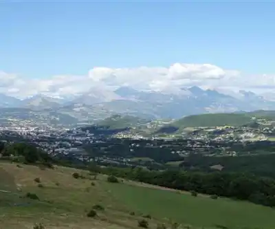
Lac de Pelleautier is one of those hikes that earns its place in the Hautes-Alpes without demanding everything you've got. At 6 km round trip with just 150 meters of elevation gain, it's genuinely accessible — the kind of trail where you can actually look around and enjoy the scenery instead of grinding through every step. That said, it still delivers the alpine lake payoff that draws people to this corner of southeastern France in the first place.
The lake sits in the Hautes-Alpes, part of the Provence-Alpes-Côte d'Azur region, where the mountains are serious and the landscapes don't mess around. Getting here puts you in the heart of terrain that defines French alpine hiking — rocky ridgelines, open sky, and that particular quality of light you only get at elevation.
What the Trail Actually Feels Like
The hike starts in mixed forest, the kind of shaded, earthy-smelling stretch that eases you into the day. The trail surface is mostly packed dirt in the lower sections, transitioning to rockier ground as you gain elevation. The grade is consistent and manageable — 150 meters spread over the distance means you're climbing, but you're not scrambling. Most hikers with basic trail experience will find the pace comfortable.
As the trees thin out, the terrain opens up and the views start to build. The shift from dense woodland to more exposed subalpine ground happens gradually, which makes it satisfying rather than abrupt. By the time you reach the lake, you've moved through two distinct environments and earned the transition.
The estimated time of 2 hours and 15 minutes is reasonable for a steady hiker, but the lake is worth lingering at — factor in extra time if you plan to eat lunch, take photos, or just sit with the view for a while.
The Lake Itself
Lac de Pelleautier is the clear destination here, and it delivers. The lake sits in an open alpine setting with the surrounding peaks providing a natural frame. It's the kind of spot that rewards patience — the light changes, the reflections shift, and if you're quiet, the place has a stillness that's hard to find closer to the valley floor.
The shoreline offers several natural spots to stop and rest. There's no single "best" viewpoint — walk around a bit and find your own angle. The surrounding terrain gives photographers plenty to work with at different times of day.
Terrain and Difficulty
This trail is rated Easy, and that rating is honest. The elevation gain is modest, the trail is well-established, and there are no technical sections requiring special skills or gear. That makes it a strong choice for:
- Families with older children who are comfortable on uneven ground
- Hikers newer to alpine terrain who want a genuine mountain lake experience without overcommitting
- Anyone looking for a half-day outing that leaves energy for the rest of the day
Even on an easy trail in the Hautes-Alpes, proper footwear matters. The rocky sections in the upper half of the trail are manageable in trail runners or light hiking boots, but flip-flops or casual sneakers will make things uncomfortable. Traction counts when the ground is uneven.
Seasonal Timing
The trail is typically accessible from late spring through early fall. Spring brings wildflowers to the lower forested sections and a freshness to the air that's hard to beat, though snow can linger at higher elevations into May or June depending on the year. Summer is the most reliable window — warm temperatures, stable weather, and full access to the lake. Fall shifts the palette toward amber and gold in the forested sections, and the crowds thin out noticeably.
Winter conditions in the Hautes-Alpes are serious. Snow accumulation can make the trail impassable or require snowshoes and winter navigation skills. If you're considering an off-season visit, check current conditions before heading out — mountain weather in this region can change fast regardless of the calendar.
Wildlife and Natural Environment
The elevation change on this hike, while modest, passes through distinct ecological zones. The forested lower section supports woodland birds and the kind of small mammals that tend to disappear the moment you notice them. Higher up, the more open terrain is habitat for species adapted to alpine conditions — keep your eyes on the rocky slopes and ridgelines.
The plant life along the trail reflects the transition from lower forest to subalpine environment. Deciduous and coniferous species dominate the early sections, giving way to hardier alpine vegetation as you gain elevation. During the right window in early summer, the wildflower display in the meadow sections can be genuinely impressive.
Give wildlife space. The Hautes-Alpes is a functioning mountain ecosystem, and the animals here aren't accustomed to close human contact. Observe from a distance and keep noise to a minimum, especially in the early morning hours when activity is highest.
Getting There and Practical Notes
Access to the trailhead involves mountain roads typical of the Hautes-Alpes — expect winding routes and potentially narrow sections. Drive at an appropriate pace and check road conditions during shoulder seasons when weather can affect accessibility.
A few things worth having sorted before you leave the car:
- Water: Carry enough for the full hike. Water sources along the trail are not guaranteed, and the lake should not be used as a drinking source without proper treatment.
- Layers: Even in summer, temperatures at the lake can drop when clouds move in or the wind picks up. A light jacket takes up almost no space and earns its weight.
- Sun protection: At elevation, UV exposure increases. Sunscreen and a hat are worth the habit.
- Navigation: The trail is well-marked, but having a map or downloaded offline route on your phone is a reasonable precaution in any mountain environment.
How It Fits Into the Hautes-Alpes
The Hautes-Alpes is one of the most compelling hiking regions in France — serious peaks, an extensive trail network, and a range of difficulty levels that accommodates everyone from day-trippers to multi-day alpine trekkers. Lac de Pelleautier sits at the accessible end of that spectrum without feeling like a compromise. It's a legitimate alpine lake hike that happens to be doable for a wide range of people, which is actually a harder thing to find than it sounds.
If you're using this as a base to explore more of the region, the surrounding area offers trails that step up significantly in distance and elevation gain — Lac de Pelleautier is a solid warm-up for bigger objectives, or a satisfying standalone destination if a half-day in the mountains is exactly what you're after.
Recommended gear for this trail


Ready to go?
Everything you need to know before you goWhen?
How much?
- Hiking shoes Essential
- → Salomon Elixir Tour Mid WP · 203.38 $
- Layered clothing Essential
- Rain jacket Essential
- Trekking poles
- → Black Diamond Trail Ergo Cork · 69.99 $
- Headlamp
- → Petzl Actik Core 625 · 103.95 $
FAQ - Frequently asked questions
Everything you need to know
25 hikes under 2 hours from Montreal
Distance, elevation, parking and season for each one. The ones we go back to ourselves.
Get the guideSimilar hikes nearby
Discover other trails you might enjoy

Gorges de la Méouge
Hautes-Alpes

Parc naturel régional du Queyras - GR58
Hautes-Alpes
Lac des Neuf Couleurs
Hautes-Alpes
Lac du Pontet
Hautes-Alpes

Sentier Des Marmottes
Hautes-Alpes
Hiking near Sydney
22 trails to explore ~5037 km away
We work hard to provide the most up-to-date and error-free data possible. If something seems incorrect, let us know! Your contribution helps the whole community.
Hikers' opinions
Be the first to review!
No hiker has shared their experience yet. Share your impressions and help other hikers!