

Ready to explore Ring Mountain, California? Here's everything you need to know before you go!
Discover the trail

Trail description
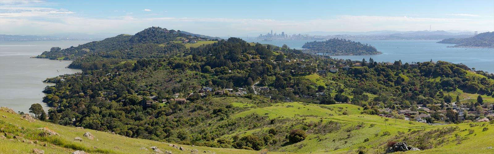
Ring Mountain is one of those spots in the Bay Area that feels genuinely wild, even though you're never far from civilization. Located on the Tiburon Peninsula in Marin County, this open space preserve sits on a rocky serpentine ridge that juts out above the surrounding neighborhoods and offers sweeping views of San Francisco Bay, Mount Tamalpais, and the city skyline. It's a place where geology, rare plants, and accessible terrain come together in a way that's hard to find this close to a major metro area.
The preserve is managed by Marin County Open Space District, and access is free. It's a popular spot for hikers, trail runners, and anyone who wants a solid outdoor experience without driving an hour into the mountains.
The Terrain
Ring Mountain sits on a serpentine outcrop, which is the key to understanding everything that makes this place unusual. Serpentine soils are naturally low in nutrients and high in heavy metals, which means most plants can't survive here. The ones that do are specialists — rare, often endemic, and found in very few places on Earth. The rocky, open ridgeline feels almost lunar in spots, with exposed greenish-gray rock breaking through the thin soil and grasses that turn golden in the dry season.
The terrain is varied. You'll move through grassland, scrub, and rocky outcrops as you gain elevation. The trails are well-worn but not heavily developed — expect some uneven footing on the rocky sections, especially near the summit area. It's not technical hiking, but it's not a flat stroll either. The climbing referenced in the trail name reflects the genuine elevation gain you'll feel as you work your way up toward the high point of the preserve.
What Makes Ring Mountain Stand Out
The botanical story here is the main draw for a lot of visitors who know what they're looking at. Ring Mountain is one of the few places in the world where you can find Tiburon mariposa lily (Calochortus tiburonensis), a species found nowhere else on the planet. It blooms in late spring and draws botanists and wildflower enthusiasts from across the region. The preserve also supports other rare serpentine endemics, making it a legitimate ecological hotspot tucked inside a suburban landscape.
Beyond the plants, the views are a major reason people keep coming back. From the upper sections of the trail, you get an unobstructed panorama of San Francisco Bay — Angel Island, the Richmond-San Rafael Bridge, the city skyline, and on clear days, a wide sweep of the surrounding hills. It's the kind of view that makes the climb feel immediately worth it.
There's also a set of Native American grinding rocks (bedrock mortars) near the summit area, evidence of the Coast Miwok people who used this land long before European contact. These are easy to miss if you're not looking, but they add a layer of history to the hike that goes well beyond the scenery.
The Hiking Experience
The trail network at Ring Mountain isn't complicated. The main route climbs steadily from the trailhead up toward the summit ridge, with the option to loop back on a slightly different path. The climbing is consistent — not brutal, but enough to get your heart rate up and give you a real sense of accomplishment when you reach the top.
The exposed ridgeline means wind is a factor, especially in the afternoon. Layers are a good idea even on warm days. The lack of tree cover also means full sun exposure for most of the route, so sunscreen and water are essentials rather than suggestions.
Trail conditions vary with the season. The grasslands are green and the wildflowers are at their peak in spring, which is when most people time their visit. By summer, the hills dry out and turn that characteristic California gold. The rocky sections stay hikeable year-round, though the trails can get muddy after significant rain in winter.
Access and Logistics
The preserve is located off Paradise Drive on the Tiburon Peninsula. Street parking is available near the trailhead — there's no large parking lot, so arriving early on weekends is a smart move. The area is popular with locals, and spots fill up on nice mornings.
There is no entrance fee to access Ring Mountain Preserve. Dogs are allowed on leash. The preserve is open during daylight hours.
The trailhead is accessible from central Marin County and is a reasonable drive from San Francisco via the Richmond-San Rafael Bridge or through Marin via US-101. It's not served by direct transit, so a car is the practical way to get there for most visitors.
Who This Hike Is For
- Wildflower and botany enthusiasts — especially in late spring when the Tiburon mariposa lily is blooming
- Bay Area residents looking for a genuine outdoor experience close to home
- Hikers who want views without committing to a full-day mountain adventure
- Anyone interested in geology — the serpentine outcrops are visually striking and ecologically fascinating
- Trail runners who want a short but punchy route with rewarding terrain
Ring Mountain punches well above its weight for a preserve this close to urban infrastructure. The combination of rare ecology, genuine views, and accessible terrain makes it a standout destination on the Tiburon Peninsula.
The Essential Hiking Checklist
Everything you need for your next hike. Bilingual, printable, 1 page.
Get your free hiking checklistRecommended gear for this trail
As an Amazon Associate I earn from qualifying purchases.


Ready to go?
Everything you need to know before you goWhen?
How much?
As an Amazon Associate I earn from qualifying purchases.
Affiliate links — LGPO may earn a commission at no extra cost to you.
- Hiking shoes Essential
- → Salomon Elixir Tour Mid WP · 203.38 $
- Layered clothing Essential
- Rain jacket Essential
- Trekking poles
- → Black Diamond Trail Ergo Cork · 69.99 $
- Headlamp
- → Petzl Actik Core 625 · 103.95 $
FAQ - Frequently asked questions
Everything you need to knowSimilar hikes nearby
Discover other trails you might enjoy

Hawk Hill, California
Bay Area
Don Edwards San Francisco Bay National Wildlife Refuge
Bay Area
Mount Hamilton, California
Bay Area
Redwood Regional Park
Bay Area
Pelican Hill, California
Bay Area
Point Reyes, California
Bay Area
Hiking near Victoria
93 trails to explore ~1171 km away
We work hard to provide the most up-to-date and error-free data possible. If something seems incorrect, let us know! Your contribution helps the whole community.
Hikers' opinions
Be the first to review!
No hiker has shared their experience yet. Share your impressions and help other hikers!