

Ready to explore Mount Hamilton, California? Here's everything you need to know before you go!
Discover the trail
Trail description
Mount Hamilton is one of the most rewarding climbs in the Bay Area — a long, winding road ascent that takes you from the valley floor all the way up to one of the highest peaks in the Diablo Range. Sitting at an elevation of 4,265 feet (1,300 m), it's home to Lick Observatory, one of the oldest mountaintop observatories in the United States, which makes the destination as interesting as the climb itself.
The Climb
The route up Mount Hamilton follows Mount Hamilton Road out of San Jose, a paved road that gains elevation steadily through a series of tight switchbacks and open ridgelines. This is primarily a cycling climb — and a well-known one at that — but hikers and trail runners also make their way up via the surrounding trails in the Joseph D. Grant County Park area at the base. The road itself is public and open to vehicles, so expect some traffic, especially on weekends.
The climb is long and exposed. There's very little shade once you leave the lower oak woodlands, and the upper sections of the mountain are open grassland and chaparral. Wind is a constant factor near the summit, and temperatures can shift significantly between the valley and the top, so layering is important regardless of the season.
What You'll Find at the Top
The summit area is dominated by Lick Observatory, operated by the University of California. The main dome houses the 36-inch refractor telescope, which was the largest in the world when it was completed in 1888. The observatory is open to the public on select days, and the visitor center offers a look inside the history of the site. It's worth checking their schedule before heading up if you want to go inside.
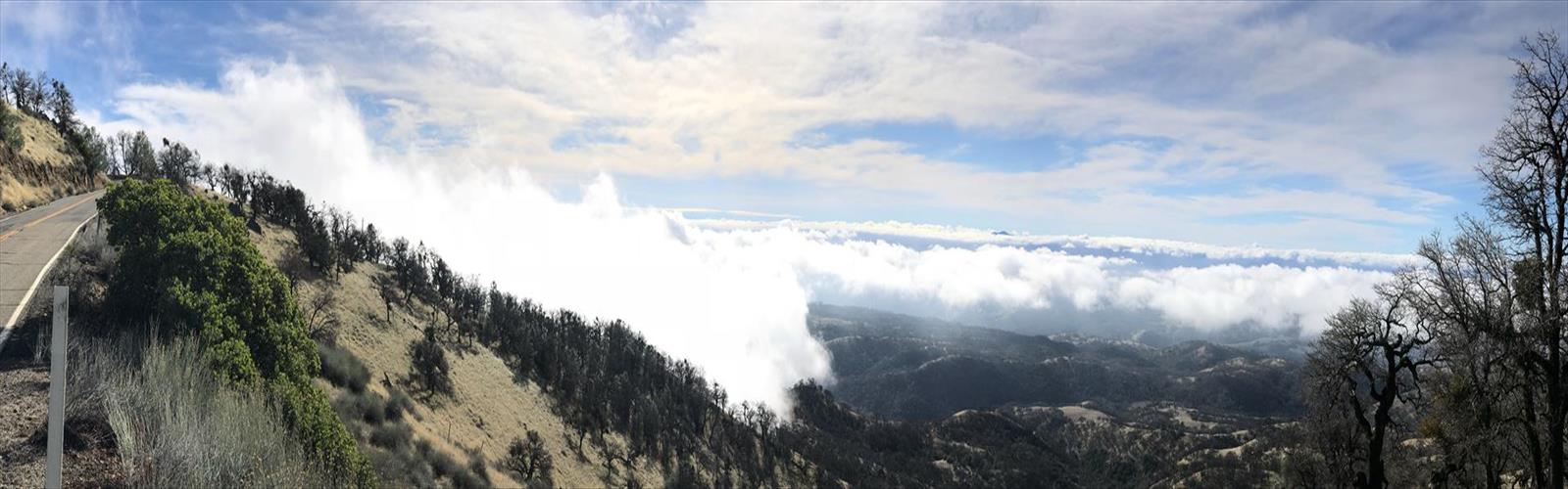
Views from the top stretch across the entire Bay Area on a clear day — you can see the South Bay, the Santa Cruz Mountains, and on exceptional days, the Sierra Nevada to the east. The summit sits above the marine layer that often blankets the valley, so you may find yourself above the clouds looking down at a white sea with peaks poking through.
Terrain and Conditions
The road surface is paved all the way to the summit, but the surrounding terrain is rugged. The Diablo Range here is dry and rocky, with grasslands, blue oak woodland, and chaparral making up most of the vegetation. Wildlife is active in the area — golden eagles, red-tailed hawks, and California ground squirrels are commonly spotted. Tule elk and black-tailed deer have also been seen in the hills around the mountain.
The road can be narrow in sections, and some of the switchbacks are tight. If you're driving up, take it slow. If you're cycling, be aware of descending vehicles on the way back down.
Getting There
Mount Hamilton Road begins in San Jose, California, off Alum Rock Avenue on the east side of the city. From downtown San Jose, it's roughly a 20-mile drive to the summit. There is parking available near the observatory at the top. No trailhead fee is required to drive up the road, though access to the observatory buildings may have its own schedule and entry requirements.
Good to Know
- Water: There are no water sources along the road. Bring everything you need, especially in summer.
- Weather: The summit can be significantly cooler and windier than San Jose. Check conditions before you go.
- Road closures: Mount Hamilton Road occasionally closes due to snow in winter or after significant rain events. Verify road status before making the trip.
- Observatory hours: Lick Observatory has specific public visiting hours that vary by season. Check the UC Observatories website for current schedules.
- Cell service: Limited to nonexistent for much of the road. Download maps offline before you leave.
Mount Hamilton is the kind of place that rewards the effort — whether you're grinding up on a bike, driving up for the views, or exploring the trails in the surrounding county park, the combination of big Bay Area scenery and a working historic observatory at the top makes it a genuinely unique destination in the region.
The Essential Hiking Checklist
Everything you need for your next hike. Bilingual, printable, 1 page.
Get your free hiking checklistRecommended gear for this trail
As an Amazon Associate I earn from qualifying purchases.


Ready to go?
Everything you need to know before you goWhen?
How much?
As an Amazon Associate I earn from qualifying purchases.
Affiliate links — LGPO may earn a commission at no extra cost to you.
- Hiking shoes Essential
- → Salomon Elixir Tour Mid WP · 203.38 $
- Layered clothing Essential
- Rain jacket Essential
- Trekking poles
- → Black Diamond Trail Ergo Cork · 69.99 $
- Headlamp
- → Petzl Actik Core 625 · 103.95 $
FAQ - Frequently asked questions
Everything you need to knowSimilar hikes nearby
Discover other trails you might enjoy
Hiking near Victoria
93 trails to explore ~1240 km away
We work hard to provide the most up-to-date and error-free data possible. If something seems incorrect, let us know! Your contribution helps the whole community.
Hikers' opinions
Be the first to review!
No hiker has shared their experience yet. Share your impressions and help other hikers!