

Ready to explore San Joaquin River Delta? Here's everything you need to know before you go!
Discover the trail
Photos: U.S. Army Corps of Engineers Sacramento District — Domaine public (Wikimedia Commons)
Trail description
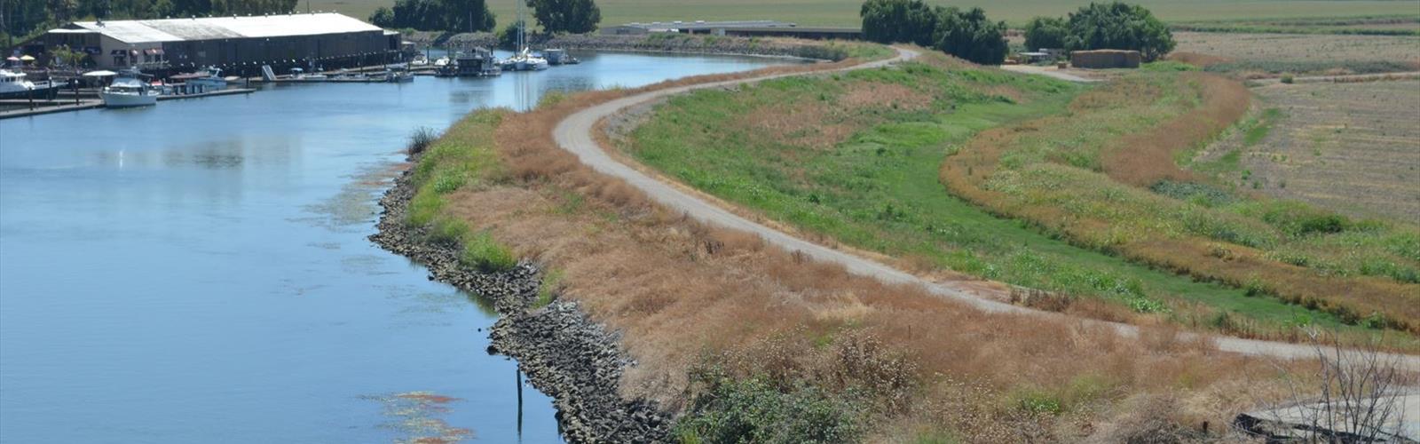
The San Joaquin River Delta sits at the heart of California's Gold Country, where the San Joaquin River fans out into a sprawling network of channels, sloughs, and wetlands before merging with the Sacramento River. This is not your typical mountain trail experience — it's a flat, water-dominated landscape that rewards patience, curiosity, and a genuine love for birds, wildlife, and wide-open skies.
What Kind of Place Is This?
The delta is one of California's most ecologically significant regions. It's a mosaic of tule marshes, riparian corridors, agricultural levees, and open water. The terrain is almost entirely flat, making it accessible to a wide range of visitors, but don't mistake "flat" for "boring." The scale of the landscape is striking — you can stand on a levee road and look out over miles of marsh grass and open water with nothing but herons and egrets for company.
Unlike forested trails where the experience is intimate and enclosed, hiking or walking in the delta puts you out in the open. The sky feels enormous here. On clear days, the light on the water is something else entirely.
The Terrain and How You Move Through It
Most access in the San Joaquin River Delta area follows levee roads and embankments — wide, firm paths that run alongside channels and sloughs. These routes are generally easy to walk and well-suited for casual outings. The ground is stable underfoot in dry conditions, though sections can get muddy after rain, so waterproof footwear is a smart call in the wetter months.
Because the area is defined by water, your movement is shaped by the channels themselves. You follow the edges, cross bridges where they exist, and work your way along the margins of the wetlands. It's a different kind of navigation than a marked forest trail — more exploratory, more dependent on knowing where the levee roads go.
Wildlife and Natural Highlights
The delta is genuinely exceptional for wildlife watching. The wetlands and riparian zones support a dense and diverse bird population year-round, with numbers spiking significantly during migration seasons. Expect to see great blue herons, great egrets, white-faced ibis, various duck species, and raptors hunting over the marsh. Sandhill cranes pass through during migration, and the area is known as an important stopover on the Pacific Flyway.
Beyond birds, the delta supports populations of river otters, beavers, and a variety of fish species. The tule marshes provide critical habitat for species that have lost ground across much of California's Central Valley. Walking quietly along the levees, especially in the early morning, gives you a real shot at close wildlife encounters.
- Birds: Great blue herons, great egrets, white-faced ibis, sandhill cranes, various waterfowl, raptors
- Mammals: River otters, beavers, muskrats
- Habitat types: Tule marsh, riparian woodland, open water channels, agricultural levees
What Makes the Delta Different from Other Gold Country Destinations
Most people associate California's Gold Country with oak-covered foothills, historic mining towns, and trails that climb through chaparral and pine. The San Joaquin River Delta is a genuine outlier in that context. It's lower, wetter, and ecologically distinct from the surrounding region. If you've been hiking the foothill trails and want something completely different without driving far, the delta delivers a real change of pace.
The sense of remoteness here can be surprisingly strong even though you're not far from populated areas. The scale of the wetlands and the absence of crowds on the levee roads means you can spend a morning out there and feel genuinely away from things.
Practical Information
Access to the delta area is spread across multiple entry points along levee roads and public access sites. Because the landscape is a patchwork of public land, private agricultural land, and managed wildlife areas, it's worth checking current access conditions before you go. Some areas are managed for hunting during specific seasons, which affects public access and what you'll encounter on the ground.
There is no single trailhead or visitor center for the San Joaquin River Delta as a whole — it's more of a region than a single destination. Bringing a detailed map or downloading offline maps before your visit is strongly recommended. Cell coverage can be spotty in the more remote sections of the delta.
- Terrain: Flat levee roads, marsh edges, riparian corridors
- Best for: Wildlife watching, birding, casual walks, photography
- Footwear: Waterproof boots recommended, especially in fall and winter
- Navigation: Download offline maps — cell coverage is unreliable in parts of the delta
- Seasonal note: Hunting seasons affect access in some areas — verify before visiting
When to Visit
The delta is a year-round destination, but each season offers something distinct. Fall and winter bring the largest concentrations of migratory waterfowl and shorebirds, making those months particularly rewarding for birders. Spring brings nesting activity and green-up in the marsh vegetation. Summer is warm to hot in the Central Valley, so early morning starts are the way to go if you're visiting between June and September.
Rain can make levee roads slippery and some low-lying access points temporarily impassable, so checking conditions after significant rainfall is a good habit before heading out.
Getting There
The San Joaquin River Delta is located in California's Gold Country region. Because access is distributed across multiple points rather than concentrated at a single trailhead, planning your specific entry point ahead of time will save you from dead ends. County road maps and land ownership layers on apps like CalTopo or Gaia GPS are useful tools for navigating the levee road network before and during your visit.
The Essential Hiking Checklist
Everything you need for your next hike. Bilingual, printable, 1 page.
Get your free hiking checklistRecommended gear for this trail
As an Amazon Associate I earn from qualifying purchases.


Ready to go?
Everything you need to know before you goWhen?
How much?
As an Amazon Associate I earn from qualifying purchases.
Affiliate links — LGPO may earn a commission at no extra cost to you.
- Hiking shoes Essential
- → Salomon Elixir Tour Mid WP · 203.38 $
- Layered clothing Essential
- Rain jacket Essential
- Trekking poles
- → Black Diamond Trail Ergo Cork · 69.99 $
- Headlamp
- → Petzl Actik Core 625 · 103.95 $
FAQ - Frequently asked questions
Everything you need to knowSimilar hikes nearby
Discover other trails you might enjoy

California Street
Gold Country
California National Historic Trail
Gold Country
Stony Hill, California
Gold Country
Stony Point, California
Gold Country
Sunset Point, California
Gold Country
Union Hill, California
Gold Country
Hiking near Victoria
93 trails to explore ~1149 km away
We work hard to provide the most up-to-date and error-free data possible. If something seems incorrect, let us know! Your contribution helps the whole community.
Hikers' opinions
Be the first to review!
No hiker has shared their experience yet. Share your impressions and help other hikers!