
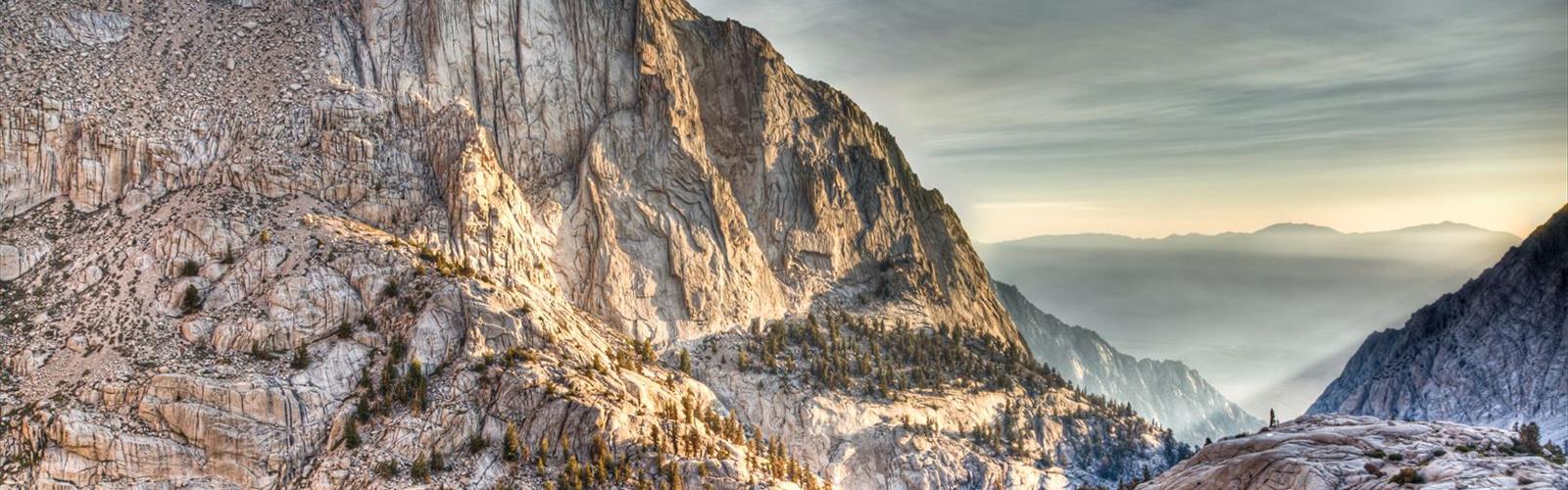

Ready to explore Mount LeConte, California? Here's everything you need to know before you go!
Discover the trail
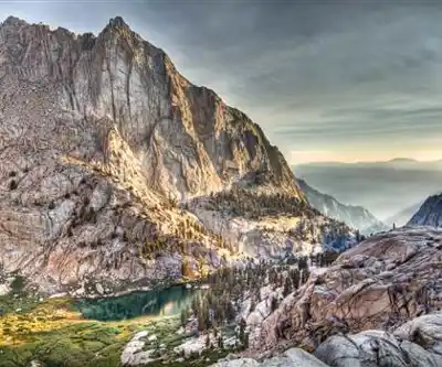
Trail description
Mount LeConte is one of the most rewarding summit objectives in the Sierra Nevada. Rising as a prominent peak in California's High Sierra, it draws climbers and scramblers who want something more than a trail walk — a real mountain experience with exposed terrain, solid granite, and sweeping views that stretch across some of the most dramatic alpine scenery in the American West.
What Kind of Objective Is This?
Mount LeConte is a climbing objective, not a casual hike. The approach and ascent involve route-finding, scrambling over rocky terrain, and navigating the kind of high-altitude environment where conditions can shift quickly. This is the Sierra Nevada at its most characteristic: big granite, thin air, and a summit that genuinely has to be earned.
The mountain sits in the heart of the Sierra Nevada range in California, surrounded by the rugged landscape that defines this part of the range. Expect talus fields, steep slopes, and sections where hands and feet both come into play. It's the kind of terrain that rewards people who are comfortable moving on rock and reading a mountain environment.
The Terrain
The Sierra Nevada is famous for its high-quality granite, and Mount LeConte is no exception. The rock is generally solid and offers good purchase for hands and feet during the scrambling sections. That said, loose rock can appear in couloirs and on steeper faces, so careful foot placement matters throughout.
The approach typically crosses open alpine terrain — meadows, boulder fields, and eventually the more technical ground near the summit. Above treeline, the landscape opens up completely, giving you unobstructed views of the surrounding peaks and ridgelines. The Sierra high country has a particular quality of light and scale that's hard to describe until you're standing in it.
The summit area itself rewards the effort with panoramic views across the range. On a clear day, the visual payoff is significant — layers of peaks receding in every direction, with the characteristic Sierra skyline of granite spires and broad ridges filling the horizon.
Who This Is For
Mount LeConte is best suited for hikers and climbers who already have experience in alpine terrain. If you've done technical trails and some off-trail travel in the mountains, you're likely ready to take this on with proper preparation. If this would be your first time above treeline or your first scramble on steep rock, it's worth building up to it with some easier objectives first.
Physical fitness matters here. The Sierra Nevada sits at high elevation, and the altitude affects everyone differently. Acclimatizing before attempting the summit — spending a night or two at elevation before your climb day — makes a real difference in how you feel on the mountain.
Planning Your Climb
The Sierra Nevada has a well-defined climbing season driven by snowpack and weather. The window when Mount LeConte is accessible without technical snow and ice gear is typically summer into early fall, but conditions vary year to year. Early season ascents may require an ice axe and crampons depending on how much snow remains in the couloirs and on the upper slopes.
Weather in the Sierra Nevada can move in fast, especially in the afternoon. Summer thunderstorms are a real hazard at elevation — starting early and being off exposed terrain before midday is standard practice for Sierra climbers. Keep an eye on the forecast and build flexibility into your plans.
Navigation on the approach and upper mountain requires map and compass skills or a reliable GPS track. There is no maintained trail to the summit, and route-finding in the talus and on the upper slopes takes attention. Knowing your route before you leave the trailhead is essential.
Permits and Access
Much of the Sierra Nevada backcountry falls under the jurisdiction of the Inyo National Forest and the John Muir Wilderness. Overnight trips in wilderness areas require a wilderness permit, and quota systems are in place for popular trailheads during peak season. If you're planning an overnight approach, check current permit requirements well in advance — permits for Sierra Nevada trailheads can fill up quickly, especially for summer weekends.
Day use generally does not require a permit, but regulations can change, so confirming current requirements with the managing agency before your trip is always a good idea.
What to Bring
- Navigation: Topographic map and compass, plus a GPS device or downloaded track. Cell service is unreliable in the backcountry.
- Layers: Temperatures drop fast at elevation, especially if clouds move in or the wind picks up. A warm mid-layer and a waterproof shell are non-negotiable.
- Sun protection: The Sierra Nevada sits at high altitude with intense UV exposure. Sunscreen, sunglasses, and a hat are essentials, not extras.
- Water and filtration: Carry enough water for the approach and have a filter or purification tablets for refilling from Sierra water sources.
- Traction gear: Depending on the season, microspikes, crampons, and an ice axe may be necessary for snow-covered sections.
- Helmet: Recommended for the scrambling sections where rockfall — from above or dislodged by your own movement — is a possibility.
- Ten Essentials: First aid kit, emergency shelter, headlamp, fire starter, and extra food. Standard backcountry kit applies fully here.
Leave No Trace
The Sierra Nevada high country is a fragile environment. Alpine soils and vegetation recover slowly from impact, and the wilderness character of this landscape depends on everyone who visits treating it with care. Stay on rock where possible to avoid trampling vegetation, pack out all waste, and follow Leave No Trace principles throughout your trip. Human waste disposal in the backcountry requires a WAG bag or proper cat hole technique well away from water sources and campsites.
Mount LeConte is the kind of objective that stays with you — the Sierra Nevada has a way of doing that to people who spend time moving through its high country on their own feet.
The Essential Hiking Checklist
Everything you need for your next hike. Bilingual, printable, 1 page.
Get your free hiking checklistRecommended gear for this trail
As an Amazon Associate I earn from qualifying purchases.


Ready to go?
Everything you need to know before you goWhen?
How much?
As an Amazon Associate I earn from qualifying purchases.
Affiliate links — LGPO may earn a commission at no extra cost to you.
- Hiking shoes Essential
- → Salomon Elixir Tour Mid WP · 203.38 $
- Layered clothing Essential
- Rain jacket Essential
- Trekking poles
- → Black Diamond Trail Ergo Cork · 69.99 $
- Headlamp
- → Petzl Actik Core 625 · 103.95 $
FAQ - Frequently asked questions
Everything you need to knowSimilar hikes nearby
Discover other trails you might enjoy

Coso Range Wilderness Trail
Sierra Nevada
Bloody Mountain, California
Sierra Nevada
Mount Lyell, California
Sierra Nevada
California Hot Springs
Sierra Nevada
Mount Hopkins, California
Sierra Nevada
Vernal and Nevada Falls (The Mist) Trail
Sierra Nevada
Hiking near Victoria
93 trails to explore ~1385 km away
We work hard to provide the most up-to-date and error-free data possible. If something seems incorrect, let us know! Your contribution helps the whole community.
Hikers' opinions
Be the first to review!
No hiker has shared their experience yet. Share your impressions and help other hikers!