

Ready to explore White Wolf Campground? Here's everything you need to know before you go!
Discover the trail
Trail description
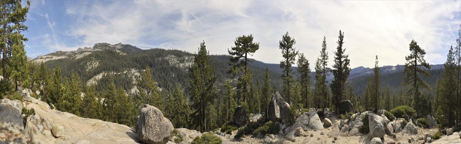
White Wolf Campground sits in one of Yosemite National Park's quieter corners, tucked away from the crowds that flood Yosemite Valley. Located along Tioga Road in the high country of California's Sierra Nevada, this spot offers a genuinely different experience from the park's more famous destinations — cooler temperatures, open subalpine meadows, and a pace that actually lets you breathe.
The Setting
At roughly 8,000 feet in elevation, White Wolf sits in a transition zone between the dense mixed-conifer forests lower on the slope and the open granite expanses of the true high country above. The landscape here is defined by lodgepole pine forest, open meadows threaded with small streams, and the kind of wide Sierra sky that makes everything feel a little more expansive. The White Wolf Meadow itself is a highlight — a classic subalpine meadow that attracts wildlife and wildflowers through the summer months.
The area has a long history as a stopping point. A small lodge and store operated here for decades, serving travelers making the long drive across Tioga Road. That legacy gives White Wolf a slightly different character than a purely backcountry destination — it's accessible, but it still feels removed from the main tourist circuit.
Trails in the Area
White Wolf serves as a trailhead for several routes into the Yosemite high country. The trails here tend to be less trafficked than those originating from Tuolumne Meadows or the Valley, which is a real advantage if you're looking for a quieter experience in the park.
- Harden Lake Trail: A relatively gentle out-and-back route that leads through lodgepole forest to a shallow lake set in a meadow. It's a good option for hikers who want a straightforward destination without a lot of elevation gain.
- Lukens Lake Trail: One of the easier hikes accessible from the Tioga Road corridor, this trail crosses open terrain and reaches a peaceful lake surrounded by meadow. It can also be accessed from a separate trailhead on Tioga Road itself.
- Grand Canyon of the Tuolumne: More ambitious hikers use White Wolf as a starting point for longer routes that descend into the Grand Canyon of the Tuolumne River — a dramatic, less-visited drainage that cuts deep into the Sierra landscape. These routes involve significant elevation change and are better suited to experienced hikers with overnight gear.
The trail network around White Wolf connects into the broader Yosemite wilderness, making it a practical base for multi-day backpacking trips as well as day hikes.
The Campground
White Wolf Campground is a tent and small RV campground operated by the National Park Service. It's a traditional-style campground with individual sites set among the trees, offering more shade and privacy than many of the more exposed high-country sites in the park. Amenities include flush toilets and a small store nearby during the operating season.
Because White Wolf is located on Tioga Road, it's only accessible when that road is open — typically from late spring through early fall, depending on snowpack. The exact opening and closing dates vary year to year, so it's worth checking current road conditions with the park before planning a trip around this area.
Reservations are generally required and fill up quickly, especially for summer weekends. If you're planning to stay here, booking well in advance through the park's reservation system is the practical move.
Wildlife and Nature
The meadow and forest mix around White Wolf creates good habitat diversity. Black bears are present throughout this part of Yosemite, and proper food storage is mandatory — bear canisters or the food storage boxes provided at campsites. Mule deer are commonly seen in and around the meadow, particularly in the early morning and evening. The area also supports a variety of bird species typical of Sierra Nevada mixed-conifer and subalpine zones.
Wildflowers in the meadow peak through mid-summer, adding color to what is otherwise a fairly muted palette of greens and grays. The streams feeding the meadow stay active through much of the summer, fed by snowmelt from higher elevations.
Getting There
White Wolf is reached via a short spur road off Tioga Road (Highway 120) inside Yosemite National Park. The turnoff is well-signed. Standard Yosemite entrance fees apply, and the park can be busy during peak summer season — arriving early in the day or on weekdays makes the experience noticeably smoother.
Tioga Road itself is one of the great drives in the Sierra Nevada, and White Wolf makes a natural stopping point whether you're camping or just passing through on a day trip across the park.
Practical Notes
- Elevation: The campground and trailhead sit at approximately 8,000 feet. If you're coming from lower elevations, give yourself a day to adjust before pushing hard on the trails.
- Weather: Afternoon thunderstorms are common in the Sierra Nevada during summer. Start hikes early and be off exposed terrain by early afternoon.
- Bears: Food storage regulations are strictly enforced. Use the provided bear boxes or a certified bear canister at all times.
- Water: Treat or filter any water collected from natural sources before drinking.
- Cell service: Minimal to nonexistent in this area. Download maps and park information before you arrive.
White Wolf is the kind of place that rewards visitors who take the time to slow down — a meadow walk at dusk, a morning cup of coffee with the sound of a nearby creek, trails that don't require fighting for a parking spot at the trailhead.
The Essential Hiking Checklist
Everything you need for your next hike. Bilingual, printable, 1 page.
Get your free hiking checklistRecommended gear for this trail
As an Amazon Associate I earn from qualifying purchases.


Ready to go?
Everything you need to know before you goWhen?
How much?
As an Amazon Associate I earn from qualifying purchases.
Affiliate links — LGPO may earn a commission at no extra cost to you.
- Hiking shoes Essential
- → Salomon Elixir Tour Mid WP · 203.38 $
- Layered clothing Essential
- Rain jacket Essential
- Trekking poles
- → Black Diamond Trail Ergo Cork · 69.99 $
- Headlamp
- → Petzl Actik Core 625 · 103.95 $
FAQ - Frequently asked questions
Everything you need to knowSimilar hikes nearby
Discover other trails you might enjoy

Coso Range Wilderness Trail
Sierra Nevada
Bloody Mountain, California
Sierra Nevada
Mount Lyell, California
Sierra Nevada
California Hot Springs
Sierra Nevada
Mount Hopkins, California
Sierra Nevada
Vernal and Nevada Falls (The Mist) Trail
Sierra Nevada
Hiking near Victoria
93 trails to explore ~1211 km away
We work hard to provide the most up-to-date and error-free data possible. If something seems incorrect, let us know! Your contribution helps the whole community.
Hikers' opinions
Be the first to review!
No hiker has shared their experience yet. Share your impressions and help other hikers!