


Ready to explore Lehigh Valley Trail? Here's everything you need to know before you go!
Discover the trail
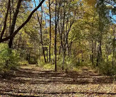
Trail description
The Lehigh Valley Trail is a rail-trail located in the Pennsylvania and New Jersey border region, following the historic Lehigh Valley Railroad corridor. Built on the former bed of the Lehigh Valley Railroad, this trail offers a flat, accessible route that follows the history of one of the Northeast's major freight lines. Whether you're out for a casual walk, a bike ride, or a longer hike, the trail delivers a relaxed experience through a mix of natural landscapes and quiet rural scenery.
Trail Character and Terrain
As a converted rail corridor, the Lehigh Valley Trail runs on a mostly level grade — the kind of terrain that makes it genuinely welcoming for hikers of all fitness levels, including families with young kids and people looking for a low-impact outing. The surface varies along different sections, ranging from packed gravel to more natural packed earth, so footwear with decent grip is always a good call even if the going is easy.
The trail passes through a mix of open fields, wooded stretches, and areas where the old railroad infrastructure is still visible — think remnants of bridges, embankments, and the characteristic straight-line geometry that gives rail-trails their distinctive feel. It's the kind of place where you can move at your own pace without worrying about steep climbs or technical footing.
What You'll Experience Along the Way
Hiking the Lehigh Valley Trail feels unhurried. The wide corridor opens up long sightlines in some sections, while tree canopy closes in overhead in others, giving the route a natural rhythm as you move through it. Birdwatching is a genuine draw here — the edge habitat created by the old rail corridor attracts a solid variety of songbirds, raptors, and waterfowl depending on the season and what's nearby.
The trail also passes through or near agricultural land, giving it a rural character that feels distinctly characteristic of the Lehigh Valley region. You're not in the deep wilderness, but you're not in a manicured park either — it sits comfortably in that in-between space that rail-trails do well.
Access and Parking
The Lehigh Valley Trail has multiple access points along its length, which makes it flexible for hikers who want to choose their own starting point or plan a point-to-point outing. Check current trailhead conditions before heading out, as parking availability and access can vary by section. Bringing a trail map or downloading an offline version is a smart move since cell coverage in rural stretches can be inconsistent.
Who This Trail Works For
The flat rail-trail format makes the Lehigh Valley Trail one of the more accessible options in the region. It's a strong choice for:
- Families with children — no significant elevation changes means kids can keep up without the hike turning into a struggle
- Beginner hikers — a great introduction to trail walking without committing to technical terrain
- Trail runners — the consistent surface and open corridor make for a comfortable run
- Cyclists — rail-trails are typically multi-use, making this a popular route for bikers as well as hikers
- Dog owners — the wide, open corridor gives dogs room to move; always check current rules regarding leash requirements before your visit
Historical Context
The Lehigh Valley Railroad was a major freight carrier that operated across the northeastern United States for well over a century before its operations wound down. The conversion of its former right-of-way into a recreational trail is part of a broader rail-trail movement that has transformed abandoned rail corridors into linear parks and greenways across the country. Walking the Lehigh Valley Trail, you're literally following the same path that freight trains once traveled — there's something grounding about that connection to the region's industrial and agricultural past.
In the Lehigh Valley region of Pennsylvania and New Jersey, this kind of history is layered into the landscape. The area has a long relationship with both agriculture and industry, and the trail reflects that heritage in the way it moves through working farmland and quiet communities.
Tips Before You Go
- Footwear: Trail runners or light hiking shoes work well. The surface is generally forgiving but can get muddy after rain.
- Water: There are no guaranteed water sources along the trail, so bring what you need for your planned distance.
- Navigation: Download a map before you go. The trail can intersect with roads and other paths, and having a reference point helps.
- Seasons: The trail is typically accessible for most of the year. Spring can bring soft or muddy sections; fall offers excellent foliage along the wooded stretches.
- Sun exposure: Open sections of the corridor offer little shade, so sunscreen and a hat are worth packing on sunny days.
Getting There
The Lehigh Valley Trail is located in the Pennsylvania and New Jersey border region. Specific trailhead coordinates and driving directions will depend on which access point you choose. Using a mapping app to navigate to the trailhead is the most reliable approach, and checking recent trail reports from local hiking groups or the managing organization before your visit will give you the most current information on conditions and access.
Recommended gear for this trail


Ready to go?
Everything you need to know before you goWhen?
How much?
- Hiking shoes Essential
- → Salomon Elixir Tour Mid WP · 203.38 $
- Layered clothing Essential
- Rain jacket Essential
- Trekking poles
- → Black Diamond Trail Ergo Cork · 69.99 $
- Headlamp
- → Petzl Actik Core 625 · 103.95 $
FAQ - Frequently asked questions
Everything you need to know
25 hikes under 2 hours from Montreal
Distance, elevation, parking and season for each one. The ones we go back to ourselves.
Get the guideSimilar hikes nearby
Discover other trails you might enjoy

Misery Mountain
Capital-Saratoga
Bauer Park
Capital-Saratoga
John Boyd Thacher State Park
Capital-Saratoga
Spier Falls/ Moreau "Saddle" Trailhead
Capital-Saratoga
Lake Bonita Trailhead
Capital-Saratoga
Colonie Town Park Trail Head
Capital-Saratoga
Hiking near Rochester
0 trails to explore ~1 km away
We work hard to provide the most up-to-date and error-free data possible. If something seems incorrect, let us know! Your contribution helps the whole community.
Hikers' opinions
Be the first to review!
No hiker has shared their experience yet. Share your impressions and help other hikers!