
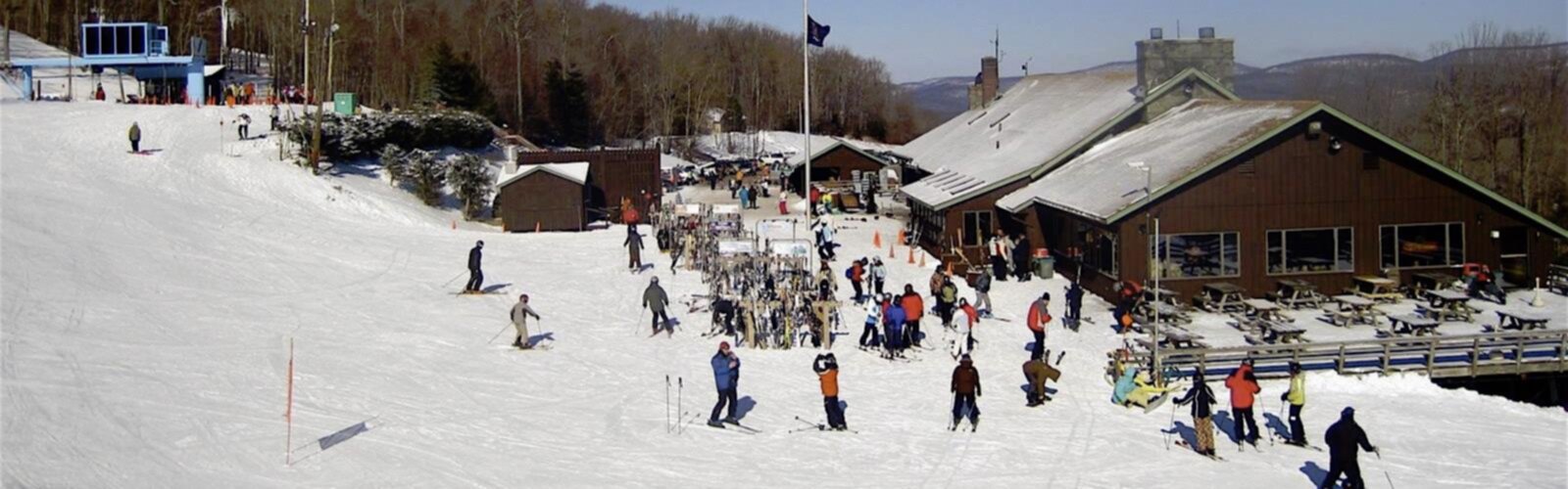

Ready to explore Belleayre Mountain? Here's everything you need to know before you go!
Discover the trail

Trail description
Belleayre Mountain stands as one of the Catskills' most accessible and rewarding hiking destinations, offering over 9 miles of diverse trails just two hours from New York City. Located in Ulster County, this mountain provides a perfect blend of challenging terrain and family-friendly options, making it a go-to destination for hikers of all experience levels throughout the year.
Trail System and Terrain
The mountain's trail network caters to every type of hiker, from beginners seeking gentle woodland walks to experienced trekkers looking for substantial elevation challenges. The Cathedral Glen Trail serves as the mountain's signature moderate hike, winding through dense hardwood forests where towering maples, birches, and oaks create a natural cathedral overhead. This trail gradually ascends through varied terrain, including rocky outcroppings and seasonal stream crossings, before opening up to expansive vistas overlooking the surrounding valleys.
For those ready to tackle more demanding terrain, the Belleayre Ridge Trail delivers a strenuous workout with significant elevation gain leading to the summit. This trail tests your endurance with steep sections and rocky scrambles, but rewards the effort with panoramic views that stretch across the entire Catskills region. The ridge walk itself offers multiple viewpoints, each providing a different perspective of the rolling mountain landscape that defines this corner of New York State.
The Belleayre Express lift provides an alternative route to higher elevations, allowing hikers to access upper trail networks without the initial climb. This option particularly appeals to families with young children or those who want to focus their energy on exploring the summit area rather than the ascent.
Seasonal Hiking Experiences
Each season transforms Belleayre Mountain into a distinctly different hiking experience. Spring brings rushing waterfalls fed by snowmelt and the emergence of wildflowers along the forest floor. Trout lilies, bloodroot, and wild leeks carpet the understory, creating natural gardens that photography enthusiasts find irresistible. The moderate temperatures and fewer crowds make spring an ideal time for peaceful trail exploration.
Summer hiking reveals the mountain at its most lush, with full canopy coverage providing natural air conditioning even on hot days. The dense foliage creates a green tunnel effect on many trails, while clearings and summit areas offer warm, sunny spots perfect for extended breaks and picnicking.
Autumn transforms Belleayre into one of the Catskills' premier foliage destinations. The mixed hardwood forests create a spectacular tapestry of reds, oranges, and yellows that peaks typically in early to mid-October. The Cathedral Glen Trail becomes particularly stunning during this season, as the forest canopy creates a kaleidoscope of color overhead while the valley views showcase the broader regional foliage display.
Winter brings a completely different character to the mountain, with snowshoeing and cross-country skiing replacing traditional hiking. The snow-covered trails offer serene beauty and peaceful solitude, while the bare trees open up winter views that remain hidden during the leafy months. The mountain's winter trail system connects with the ski area's network, providing extended exploration opportunities.
Access and Facilities
The mountain's location near Galli Curci Road provides straightforward access to both the main trailheads and the ski area facilities. The Discovery Lodge serves as the primary visitor hub, offering restrooms, trail maps, and information about current trail conditions. This facility makes an excellent starting point for planning your hike and serves as a comfortable base for groups or families.
Multiple picnic areas scattered throughout the mountain provide designated spots for meals and rest breaks. These areas typically feature tables and basic facilities, making them ideal for extended family outings or group hikes where people want to spend significant time on the mountain beyond just hiking.
The proximity to Roxbury adds another dimension to visits, as this charming Catskills town offers dining, lodging, and supply options for those planning overnight stays or multi-day explorations of the region. The town's historic character and local businesses provide a pleasant complement to the outdoor activities on the mountain.
What Makes Belleayre Special
Unlike some Catskills peaks that require long approaches or difficult access, Belleayre Mountain delivers substantial hiking rewards with relatively convenient logistics. The combination of the ski area infrastructure and dedicated hiking trails creates a unique environment where serious hikers and casual walkers can find their preferred level of challenge and solitude.
The mountain's trail system showcases the classic Catskills hiking experience: dense forests, rocky terrain, seasonal water features, and rewarding summit views. The varied elevation profile means hikers encounter different forest ecosystems and microclimates within a single outing, from the cool, moist valley floors to the windier, more exposed ridge areas.
The historical significance of the area, including Dot Nebel's contributions to the mountain's development, adds cultural depth to the natural experience. Learning about the people who helped establish and maintain this hiking destination provides context for understanding how the Catskills region has evolved as a recreational area.
Whether you're seeking a challenging day hike with significant elevation gain, a moderate forest walk with scenic rewards, or a family-friendly outdoor experience with amenities and easy access, Belleayre Mountain delivers the authentic Catskills hiking experience within reach of the metropolitan area's outdoor enthusiasts.
The Essential Hiking Checklist
Everything you need for your next hike. Bilingual, printable, 1 page.
Get your free hiking checklistRecommended gear for this trail
As an Amazon Associate I earn from qualifying purchases.


Ready to go?
Everything you need to know before you goStarting Point
To access the hiking trails, you can start at the main trailhead located at the Belleayre Mountain Ski Center. The address is 181 Galli Curci Road, Highmount, NY 12441. There is a parking lot available at this location for visitors.
When?
How much?
As an Amazon Associate I earn from qualifying purchases.
Affiliate links — LGPO may earn a commission at no extra cost to you.
- Hiking shoes Essential
- → Salomon Elixir Tour Mid WP · 203.38 $
- Layered clothing Essential
- Rain jacket Essential
- Trekking poles
- → Black Diamond Trail Ergo Cork · 69.99 $
- Headlamp
- → Petzl Actik Core 625 · 103.95 $
FAQ - Frequently asked questions
Everything you need to knowSimilar hikes nearby
Discover other trails you might enjoy

Old Mill Falls
Catskills
Catskill Scenic Trail
Catskills
Cliff Lake
Catskills
Plattekill Falls
Catskills
Devil's Path Trail
Catskills
Ashokan Reservoir
Catskills
Hiking near Poughkeepsie
0 trails to explore ~68 km away
We work hard to provide the most up-to-date and error-free data possible. If something seems incorrect, let us know! Your contribution helps the whole community.
Hikers' opinions
Be the first to review!
No hiker has shared their experience yet. Share your impressions and help other hikers!