
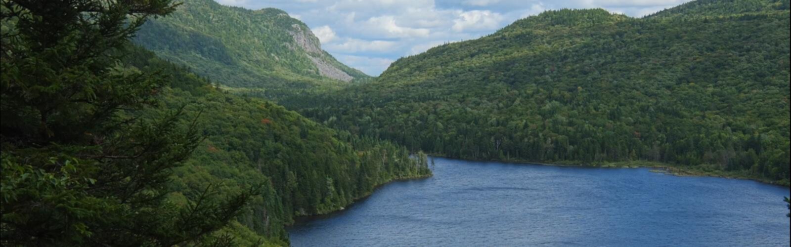

Ready to explore Les sentiers du Mont-Bélanger? Here's everything you need to know before you go!
Discover the trail
Oh no! We don't have any photos 😢
This trail hasn't been captured yet. Be the first to share your adventure!Trail description
Mont Bélanger rises to 960 meters near Saint-Robert-Bellarmin in the Eastern Townships, offering a network of over 25 km of well-marked trails across the mountain. The 18-km primary trail network is designed to be hiked in sections or combined into longer loops, which gives you flexibility depending on how much time you have. The 400 meters of elevation gain is distributed across the full system rather than concentrated in one climb, so individual sections vary between gentle grades and steeper pitches.
Terrain and Features
The trail system spans multiple peaks with an observation tower (6 meters/20 feet) erected at the summit of Mont Bélanger. From the summit, the tower provides magnificent views of the surrounding lakes and mountains of the Eastern Townships region. The terrain shifts between forest corridors and rocky areas with scattered boulders, featuring dramatic geological formations including spectacular fallen rocks that characterize this biological refuge.
The open slopes and rocky scree sections break up the forested areas and create exposed geology that tells the story of how this landscape was shaped. Footing here requires more attention than the forest paths, so take your time and watch your step.
Old-Growth Forest Ecosystem
One of the most distinctive features of Mont Bélanger is its old-growth forest, home to white spruce and other coniferous species. The ancient trees in this ecosystem are over 200 years old, with some specimens exceeding one meter in diameter. Walking through these mature forests creates a unique atmosphere with dense canopy and filtered light that is characteristic of old-growth ecosystems. This biological refuge is one of the more significant examples of old-growth forest accessible by trail in the Eastern Townships region.
Seasonal Highlights
The best times to visit Mont Bélanger trails are June through September. Each season changes the character of the mountain meaningfully. Summer offers natural shade within the old-growth forest sections, while exposed ridges catch cooling breezes.
Fall is particularly strong given the mix of deciduous and coniferous species across different elevations. Spring brings streams to higher flow as snowmelt feeds the watershed, and the forest floor comes alive with early wildflowers, though expect muddy conditions on lower trail sections as the ground thaws.
Winter transforms the landscape significantly, with snow covering the terrain and ice formations developing on water features. Winter hiking here requires proper preparation for variable conditions.
Trail Conditions and Navigation
The trails are well-marked and well-maintained. Forest sections generally offer stable, well-defined footing. Rocky and scree sections require more careful foot placement due to loose rock underfoot. The trails can be muddy after rain, particularly in lower sections and around wet areas. The trail network is accessible to hikers with basic fitness and some experience on natural surfaces.
What Makes Mont Bélanger Worth Visiting
Old-growth forest is increasingly rare in the Eastern Townships, and Mont Bélanger's ancient white spruce forest is one of the more significant examples accessible by trail in the region. The combination of 200-year-old trees, geological drama, and views from the observation tower at the summit gives this trail network distinct landmarks. The flexible trail design means you can return and take different route combinations without repeating the same experience.
The Essential Hiking Checklist
Everything you need for your next hike. Bilingual, printable, 1 page.
Get your free hiking checklistRecommended gear for this trail
As an Amazon Associate I earn from qualifying purchases.


Ready to go?
Everything you need to know before you goWhen?
How much?
As an Amazon Associate I earn from qualifying purchases.
Affiliate links — LGPO may earn a commission at no extra cost to you.
- Hiking shoes Essential
- → Salomon Elixir Tour Mid WP · 203.38 $
- Layered clothing Essential
- Rain jacket Essential
- Trekking poles
- → Black Diamond Trail Ergo Cork · 69.99 $
- Headlamp
- → Petzl Actik Core 625 · 103.95 $
FAQ - Frequently asked questions
Everything you need to knowSimilar hikes nearby
Discover other trails you might enjoy

Mount Brome (Bromont)
Eastern Townships
Mont Pinacle
Eastern Townships
Sutton Natural Environment Park
Eastern Townships

Parc De La Gorge De Coaticook
Eastern Townships

Mount Orford National Park
Eastern Townships

Parc national de Frontenac
Eastern Townships
Hiking near Sherbrooke
53 trails to explore ~119 km away
We work hard to provide the most up-to-date and error-free data possible. If something seems incorrect, let us know! Your contribution helps the whole community.
Hikers' opinions
Be the first to review!
No hiker has shared their experience yet. Share your impressions and help other hikers!