

Ready to explore Parc De La Gorge De Coaticook? Here's everything you need to know before you go!
Discover the trail
Available trails
| Trails | Distance | Elevation | Duration | Difficulty | GPX |
|---|---|---|---|---|---|
| 3.5 km | 84 m | 54min | Beginner | ||
| 3.5 km | 26 m | 49min | Beginner | ||
| 8.5 km | 152 m | 2h | Advanced |
Trail description
The Gorge Itself
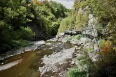
The centerpiece of the park is the gorge — a narrow, steep-walled canyon cut by the Coaticook River. The walls rise sharply on both sides, and the river runs far below, giving you that mix of exposure and awe that makes gorge hiking so compelling. The rock faces are draped in moss and ferns, and the sound of rushing water follows you along most of the trail network. It's the kind of terrain that feels earned even when the walking isn't technically difficult.
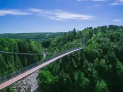
The park is also home to the longest suspended footbridge in North America. Crossing it is a highlight for most visitors — the bridge sways gently underfoot, the gorge opens up below you, and the scale of the whole thing hits you in a way that photos don't quite capture. It's not a white-knuckle experience, but it does get your attention.
Services and amenities
This information may vary by season.
Recommended gear for this trail


Ready to go?
Everything you need to know before you goStarting Point
To access it, take exit 21 off Highway 55, then take Route 141 south to Coaticook and follow the signs.
When?
How much?
- Hiking shoes Essential
- → Salomon Elixir Tour Mid WP · 203.38 $
- Layered clothing Essential
- Rain jacket Essential
- Trekking poles
- → Black Diamond Trail Ergo Cork · 69.99 $
- Headlamp
- → Petzl Actik Core 625 · 103.95 $
FAQ - Frequently asked questions
Everything you need to knowThe Essential Hiking Checklist
Everything you need for your next hike. Bilingual, printable, 1 page.
Download the free checklistSimilar hikes nearby
Discover other trails you might enjoy

Mount Brome (Bromont)
Eastern Townships

Mont Pinacle
Eastern Townships

Sutton Natural Environment Park
Eastern Townships

Mount Orford National Park
Eastern Townships

Parc national de Frontenac
Eastern Townships

Promenade du Lac-des-Nations
Eastern Townships
Hiking near Sherbrooke
53 trails to explore ~30 km away
We work hard to provide the most up-to-date and error-free data possible. If something seems incorrect, let us know! Your contribution helps the whole community.
Hikers' opinions