

Ready to explore Parc national de Frontenac? Here's everything you need to know before you go!
Discover the trail


Available trails
| Trails | Distance | Elevation | Duration | Difficulty | GPX |
|---|---|---|---|---|---|
| 3.2 km | 60 m | 48min | Beginner | ||
| 7.4 km | 75 m | 2h | Beginner | ||
| 5 km | 10 m | 1h | Beginner | ||
| 8 km | 10 m | 2h | Beginner | ||
| 5.7 km | 5 m | 1h30 | Beginner | ||
| 6.5 km | 35 m | 1h30 | Intermediate | ||
| 10.2 km | 120 m | 2h30 | Advanced |
Trail description
Description
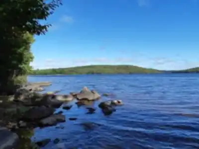
Parc national de Frontenac sits in the Estrie region of Quebec (specifically the Cantons-de-l'Est and Chaudière-Appalaches regions), and it's one of those parks that quietly delivers a lot more than people expect. Built around Lac Saint-François, the park offers a mix of hiking, paddling, and wildlife watching in a landscape that feels genuinely wild despite being accessible from several nearby towns.
The Setting
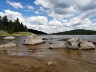
The park is divided into two sectors: the North Sector and the South Sector, each with its own character and access point. The North Sector tends to attract hikers looking for forest trails and lake views, while the South Sector is more oriented toward water-based activities. Both sectors share the same boreal and mixed forest backdrop, with wetlands, bogs, and shoreline habitats woven throughout.
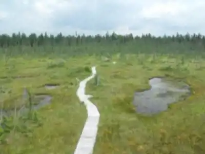
The landscape here is shaped by deciduous hills, ponds, marshes, and the Winslow Massif, which creates an interesting ecological transition zone. You'll find species typical of both environments, which makes the park particularly interesting for anyone who pays attention to birds, plants, or amphibians. The park hosts more than 200 species of birds and many mammals.
Hiking at Parc national de Frontenac
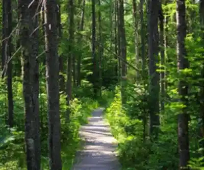
The trail network covers both sectors and ranges from 3 to 16 km in length, with difficulty ratings from easy to intermediate. The terrain includes rooted paths through mixed and coniferous forest, open sections near the water, occasional viewpoints over Lac Saint-François, and sections through vast peat bogs. Elevation gain is generally modest rather than dramatic — this isn't a park known for steep climbs, but the trails are varied enough to stay interesting.
Trails are well-marked and maintained by Sépaq, the organization that manages Quebec's national parks network. Signage is consistent, and trail maps are available at the welcome stations in each sector. Whether you're doing a short loop or linking multiple trails for a longer day, the network is easy to navigate.
What Makes This Park Stand Out
The combination of a natural lake with a proper trail network is what sets Parc national de Frontenac apart from other parks in the Estrie region. A lot of parks in southern Quebec lean heavily toward one activity or another — Frontenac genuinely supports both hikers and paddlers, and the two don't get in each other's way.
The wetland areas are a real highlight. The park protects significant bog and marsh habitat, and these zones are accessible from certain trails. If you're into birding, these sections are worth slowing down for — the park is known as a strong spot for waterfowl, shorebirds, and forest species alike, with more than 200 bird species documented.
Wildlife in general is a draw here. The park's protected status and relatively low visitor pressure compared to more famous Quebec parks means animals are less skittish. White-tailed deer, beaver, and various raptor species are commonly spotted.
Practical Information
Parc national de Frontenac is managed by Sépaq, and an entry fee applies. If you hold a Sépaq annual pass, it covers access here as it does at other provincial parks in the network. The welcome stations at each sector are your first stop — staff there can give you current trail conditions, maps, and any relevant updates about closures or wildlife activity.
- Two sectors: North and South, each with separate access roads and parking areas.
- Entry fee: Standard Sépaq daily or annual pass required.
- Dogs: Check with Sépaq for current pet policies, as rules can vary by trail and sector.
- Facilities: Both sectors have washrooms, picnic areas, and boat launches. The park also offers camping and rental equipment for water activities.
- Season: The park operates year-round, with different activities available depending on the season — snowshoeing and cross-country skiing in winter, hiking and paddling in the warmer months.
Getting There
The park is located in the Estrie region of Quebec (Cantons-de-l'Est and Chaudière-Appalaches regions). The two sectors have different access points, so it's worth deciding in advance which one you're heading to and confirming the route before you leave. GPS coordinates for each sector entrance are available on the Sépaq website, and cell service can be limited once you're in the area, so downloading an offline map is a good habit.
Parking is available at both sectors. On busy summer weekends, arriving early is advisable — the park can fill up, and Sépaq occasionally implements reservation systems for parking during peak periods.
Tips for Your Visit
- Bring bug protection, especially if you're visiting in late spring or early summer. The wetland areas are beautiful but come with mosquitoes.
- Water shoes or sandals are useful if you plan to combine hiking with any shoreline exploration.
- The trails near the lake can be muddy after rain — waterproof footwear is worth it.
- If you're combining hiking with paddling, the park has canoe and kayak rentals available, which makes it easy to experience both sides of the park in a single day.
- Check the Sépaq website or call ahead before your visit to confirm current conditions, especially during shoulder seasons when some facilities may have limited hours.
Parc national de Frontenac rewards visitors who take their time — the trails, the lake, and the wetlands each offer something different, and the park is large enough that you can easily fill a full day without retracing your steps.
Services and amenities
This information may vary by season.
Recommended gear for this trail


Ready to go?
Everything you need to know before you goStarting Point
There are two ways to get there:
Saint-Daniel sector: from Thetford Mines, take route 267 south and follow the indications.
South sector: from Sherbrooke, follow route 108 east to Saint-Romain, then turn left on route 263 and continue to the park entrance.
When?
How much?
- Hiking shoes Essential
- → Salomon Elixir Tour Mid WP · 203.38 $
- Layered clothing Essential
- Rain jacket Essential
- Trekking poles
- → Black Diamond Trail Ergo Cork · 69.99 $
- Headlamp
- → Petzl Actik Core 625 · 103.95 $
FAQ - Frequently asked questions
Everything you need to knowThe Essential Hiking Checklist
Everything you need for your next hike. Bilingual, printable, 1 page.
Download the free checklistSimilar hikes nearby
Discover other trails you might enjoy

Mount Brome (Bromont)
Eastern Townships

Mont Pinacle
Eastern Townships

Sutton Natural Environment Park
Eastern Townships

Parc De La Gorge De Coaticook
Eastern Townships

Mount Orford National Park
Eastern Townships

Promenade du Lac-des-Nations
Eastern Townships
Hiking near Sherbrooke
53 trails to explore ~75 km away
We work hard to provide the most up-to-date and error-free data possible. If something seems incorrect, let us know! Your contribution helps the whole community.
Hikers' opinions