

Ready to explore Chutes Manitou? Here's everything you need to know before you go!
Discover the trail
Trail description
Description
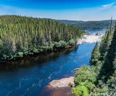
Chutes Manitou is one of those places in Quebec's Côte-Nord region that rewards the effort it takes to get there. Located in the Duplessis area, roughly 35 km west of Rivière-au-Tonnerre and 85 km east of Sept-Îles, these falls offer a wilderness experience shaped by boreal forest and the ancient Canadian Shield landscape.
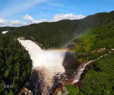
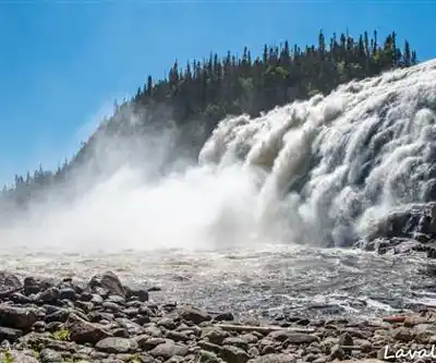
The Falls Themselves
The star of the attraction is the main waterfall, one of the most spectacular in the region, dropping approximately 35 metres. Manitou Falls creates mist and a powerful roar that can be heard well before you reach the viewpoint. The surrounding rock faces show the geological age of this part of the Canadian Shield. The name Manitou carries Indigenous roots, referencing a spiritual force or presence in Algonquian traditions.
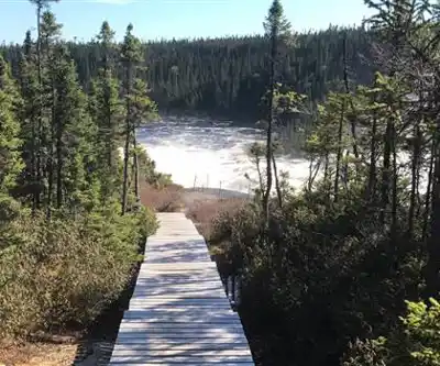
The Trail Experience
This is an easy, accessible trail suitable for most hikers. The main trail is approximately 1.3 km in length with an elevation gain of 50 metres, taking about 30 minutes to 1 hour to complete as an out-and-back hike. The trail moves through classic boreal forest — spruce, fir, and birch dominating the canopy.
Two distinct trails exist on either side of the river. The most popular route requires crossing the Manitou River bridge and offers the best views of the falls. The approach follows the river corridor, giving you a gradual build-up: first the sound of moving water, then glimpses of the current, and finally the full view of the falls.
Terrain and Trail Conditions
The Duplessis region sits on the Canadian Shield, where bedrock is close to the surface. The trail features exposed roots and rocky sections that require attention to footing, especially after rain. The forest floor is typically damp and mossy. Waterproof hiking boots with ankle support are recommended given the terrain and proximity to water.
What to Expect
The Côte-Nord region is remote by Quebec standards. Getting here requires planning and a reliable vehicle for the long drive. Cell service is limited, so download offline maps before departing. The boreal climate means cool temperatures even in summer. Bugs — particularly blackflies and mosquitoes — can be intense from late spring through midsummer.
Best Time to Visit
Summer is the most accessible season, with the trail passable and the falls running strong from snowmelt through the warmer months. Early summer brings the highest water volume, though insects are also at peak. Late summer and early fall offer fewer bugs and beautiful boreal forest colours. Winter and spring shoulder seasons present challenging conditions.
Why Chutes Manitou Stands Out
The Côte-Nord doesn't receive the same visitor traffic as southern Quebec parks, making Chutes Manitou a relatively uncrowded destination. The falls themselves are a dramatic focal point, and the site is easily accessible compared to many remote boreal attractions. With a 4.8-star rating from nearly 100 reviews, it's a well-regarded hiking destination that offers genuine wilderness character without extreme technical difficulty.
Recommended gear for this trail


Ready to go?
Everything you need to know before you goStarting Point
To access the hiking trails, you can start at the main trailhead located at the parking lot on Route 138. If you're coming from the west, follow Route 138 eastward until you reach the designated parking area. From the east, take Route 138 westward to find the same parking location. There is only one primary trailhead for these trails, so it should be straightforward to locate once you are on Route 138.
When?
How much?
- Hiking shoes Essential
- → Salomon Elixir Tour Mid WP · 203.38 $
- Layered clothing Essential
- Rain jacket Essential
- Trekking poles
- → Black Diamond Trail Ergo Cork · 69.99 $
- Headlamp
- → Petzl Actik Core 625 · 103.95 $
FAQ - Frequently asked questions
Everything you need to knowThe Essential Hiking Checklist
Everything you need for your next hike. Bilingual, printable, 1 page.
Download the free checklistSimilar hikes nearby
Discover other trails you might enjoy

Parc National D'anticosti
North Shore

Sentier Pédestre De Portneuf-sur-mer
North Shore

Réserve de parc national de l'Archipel-de-Mingan
North Shore

Mont Groulx
North Shore

Cascades De Rivière-au-tonnerre
North Shore

Sentier De La Mine Cap Feldspath
North Shore
Hiking near Quebec City
40 trails to explore ~92 km away
We work hard to provide the most up-to-date and error-free data possible. If something seems incorrect, let us know! Your contribution helps the whole community.
Hikers' opinions