

Ready to explore Mont Groulx? Here's everything you need to know before you go!
Discover the trail
Trail description
Description
Mont Groulx — also known as the Uapishka Mountains — is one of Québec's most remote and rewarding mountain destinations. Tucked into the Côte-Nord region, it sits on the Canadian Shield and rises to peaks of up to 1,104 meters (3,622 feet). This isn't a place you stumble across on a weekend drive. Getting here takes intention, and that's exactly the point. The landscape is genuinely wild, the terrain demands respect, and the experience stays with you.
What makes Mont Groulx worth the trip
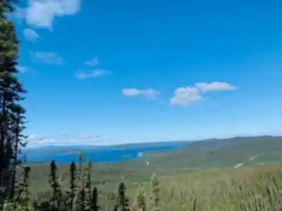
The appeal here is straightforward: big, open country that feels untouched. As you gain elevation, the environment shifts from dense boreal forest to exposed alpine tundra, and that transition is one of the most memorable parts of hiking in this area. The tree cover thins, the ground opens up, and suddenly you're moving through a landscape that feels more like the far north than anything you'd find in southern Québec.
The views from the high ground are genuinely panoramic. Multiple ridges and summits spread out around you, and on a clear day the scale of the terrain becomes fully apparent. It's the kind of place where you stop not because you're tired, but because the view demands it.
The trail
This route covers 12 km with 850 meters of elevation gain, rated Hard, with an estimated time of 6 hours 30 minutes. That combination — significant distance, substantial climbing, and remote terrain — means this is a hike for people who are comfortable in the backcountry and have solid fitness going in.
A well-known route in the area is the Sentier des Sommets, which links several peaks and delivers wide views repeatedly as you move along the high ground. Ridge walking, summit-to-summit momentum, and changing vistas are the defining features of this kind of outing at Mont Groulx. Even on shorter routes, the same general arc applies: a forested approach, a gradual transition to more open terrain, and a wilder, more exposed feel as you climb.
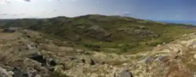
The footing is characteristically Canadian Shield — hard rock, uneven surfaces, and sections that require attention. This isn't a groomed trail. Expect to pick your line in places, especially higher up where the tundra gives way to bare ridgeline.
What the hike feels like on the ground
The lower sections move through lush boreal forest — sheltered, shaded, and dense. It's a good warm-up, and the forest has its own character worth noticing. As you climb, the trees get shorter and more scattered, and the wind starts to make itself known. By the time you reach the upper sections, you're in full alpine tundra: low vegetation, wide sightlines, and a sense of exposure that's both invigorating and humbling.
The ruggedness is real. Sturdy footwear matters here — not just for comfort, but for safety on rocky, uneven ground. A steady pace and a conservative approach to timing will serve you better than trying to push through quickly. This is terrain where a little extra margin in your schedule makes the whole day more enjoyable.
Wildlife and ecosystems
The shift from forest to tundra isn't just a visual change — it's an ecological one. Mont Groulx supports diverse flora and fauna adapted to northern conditions. Caribou herds are known to graze on the tundra, and the ridgelines are worth scanning for rare bird species. Even if you don't spot large animals directly, the signs of wildlife are part of what makes this environment feel genuinely alive and intact.
The ecosystem here is sensitive. Tundra vegetation recovers slowly from disturbance, so where you step matters — especially off-trail in the upper sections.
Best time to go
The reliable window for hiking Mont Groulx is late June through early September. Within that period, conditions are generally stable enough for full-day outings, though weather can shift quickly once you're above treeline. Temperatures on exposed ridges can feel significantly colder than at the trailhead, and wind is a real factor at elevation. Layered clothing that covers the full range — warm forest to cold, windy summit — is the right approach.
What to pack
- Sturdy, ankle-supporting boots — the rocky terrain makes this non-negotiable
- Layered clothing, including a wind layer for the exposed upper sections
- Plenty of water and food — 850 meters of climbing over 12 km burns more than expected
- Navigation tools (map, compass, or GPS) — remote terrain with limited landmarks at elevation
- First aid kit and emergency gear appropriate for backcountry travel
Planning for remote terrain
Mont Groulx is consistently described as a true wilderness destination, and that framing matters practically. Tell someone your itinerary before you go — where you're starting, where you're headed, and when you expect to be back. That single step is one of the most effective safety measures for remote hiking.
Build in time to make conservative decisions: turning around if weather deteriorates, managing your pace so you're not descending in fading light, and choosing an objective that genuinely matches your experience level. The challenge here is real, and so is the reward — but both are best experienced when you've planned with enough margin to travel calmly.
Leaving it as you found it
Mont Groulx is a pristine wilderness, and it stays that way through consistent, collective care. Stick to marked trails where they exist, and follow Leave No Trace principles throughout — pack out everything you bring in, and be mindful of where you step in sensitive tundra areas. In an environment where vegetation grows slowly and human impact lingers, small habits make a real difference over time.
Recommended gear for this trail


Ready to go?
Everything you need to know before you goStarting Point
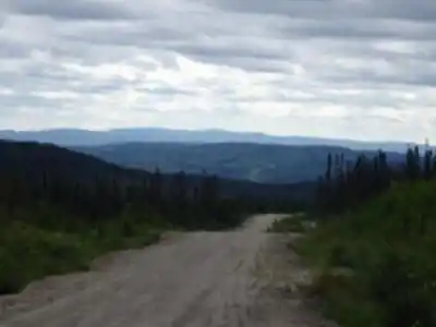
To get to the mont groulx trails, you must go to Saint-Augustin-de-Desmaures. From there, take Route 138 East toward Forestville. After passing through Forestville, continue on route 138 East until you reach the junction for mont groulx. Turn right and climb to the summit.
When?
How much?
- Hiking shoes Essential
- → Salomon Elixir Tour Mid WP · 203.38 $
- Layered clothing Essential
- Rain jacket Essential
- Trekking poles
- → Black Diamond Trail Ergo Cork · 69.99 $
- Headlamp
- → Petzl Actik Core 625 · 103.95 $
FAQ - Frequently asked questions
Everything you need to knowThe Essential Hiking Checklist
Everything you need for your next hike. Bilingual, printable, 1 page.
Download the free checklistSimilar hikes nearby
Discover other trails you might enjoy

Parc National D'anticosti
North Shore

Sentier Pédestre De Portneuf-sur-mer
North Shore

Réserve de parc national de l'Archipel-de-Mingan
North Shore

Chutes Manitou
North Shore

Cascades De Rivière-au-tonnerre
North Shore

Sentier De La Mine Cap Feldspath
North Shore
Hiking near Quebec City
40 trails to explore ~547 km away
We work hard to provide the most up-to-date and error-free data possible. If something seems incorrect, let us know! Your contribution helps the whole community.
Hikers' opinions