

Ready to explore Réserve de parc national de l'Archipel-de-Mingan? Here's everything you need to know before you go!
Discover the trail
Trail description
Description
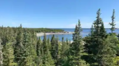
The Mingan Archipelago National Park Reserve is one of the most distinctive natural environments in all of Canada. Stretching along the north shore of the Gulf of St. Lawrence in Quebec's Duplessis region, this park reserve protects a chain of islands and islets shaped by millennia of wave erosion, glacial activity, and the relentless force of the sea. If you're looking for a hiking destination that feels genuinely unlike anywhere else, this is it.
What Makes This Place Unique
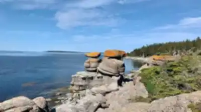
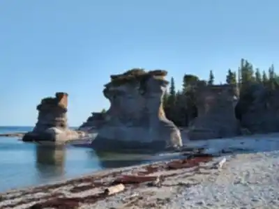
The defining feature of the Mingan Archipelago is its monoliths — massive limestone erosion sculptures that rise from the shoreline in shapes that seem almost deliberate. These formations, carved by the sea over thousands of years, are found nowhere else in Canada and give the archipelago an otherworldly quality that hikers and photographers consistently find hard to describe until they've seen it in person. The landscape feels ancient in a way that's immediately tangible when you're standing next to one of these structures.
Beyond the geology, the park reserve sits at a biological crossroads. The islands support a mix of boreal forest, peat bogs, and coastal habitats that shelter a remarkable variety of wildlife. Seabirds are a major draw — including razorbills, common murres, and other species that nest on the islands. The waters around the islands support several species of whales, including minke whales and fin whales. Seals haul out on rocky shores throughout the season.
Getting There and Getting Around
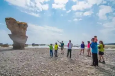
Access to the archipelago is by boat. The park reserve has two main service points on the mainland: one near Havre-Saint-Pierre, which serves the western islands, and one near Longue-Pointe-de-Mingan, which provides access to the eastern sector. Boat shuttles operate during the visitor season, and Parks Canada coordinates departures to the various islands. Because the islands are spread across a significant stretch of coastline, most visitors focus on one sector per day or plan multi-day stays on islands that have camping facilities.
The hiking experience here is fundamentally tied to the island-hopping nature of the park. You arrive by boat, explore on foot, and return to the mainland — or set up camp and stay. Trails vary by island, ranging from short interpretive loops to longer walks that take you across the full width of an island and along exposed coastal edges. Wooden boardwalks and coastal paths provide access to the islands.
The Hiking Experience
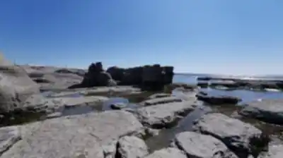
Trails in the Mingan Archipelago tend to be relatively flat — the islands themselves don't have dramatic elevation changes — but the terrain is varied and often requires attention underfoot. Coastal paths can be rocky and uneven, and some routes cross through boggy sections where footing gets soft. The reward for paying attention to where you step is constant: at almost every turn, there's either a striking geological formation, a seabird colony, or an open view across the Gulf.
The monoliths are the centerpiece of most island walks. Some trails are specifically routed to bring you close to the largest formations, and the scale of these structures only becomes clear when you're standing beside them. The limestone has been sculpted into arches, columns, and mushroom-like shapes — each island has its own character, and experienced visitors often have strong opinions about which islands are worth prioritizing.
Wildlife encounters are a regular part of hiking here. Nesting seabirds are present in significant numbers during the summer season, and Parks Canada has designated sensitive nesting areas where visitors are asked to keep their distance. Seals are commonly spotted from coastal trails. Whale sightings from shore are possible, though boat excursions give you a much better chance of close encounters.
Camping and Overnight Stays
Several islands in the park reserve have designated camping areas, making it possible to spend a night or more in the archipelago. Camping here is a genuinely immersive experience — the islands are quiet after the day-trippers leave, and the combination of coastal sounds, open skies, and isolation is something that stays with people. Reservations through Parks Canada are required, and facilities vary by island, so it's worth checking current availability and services before planning an overnight trip.
Practical Information
- Access: By boat shuttle from Havre-Saint-Pierre or Longue-Pointe-de-Mingan. No road access to the islands.
- Season: The park reserve operates during the summer season. Check Parks Canada for current opening dates and boat shuttle schedules.
- Fees: Parks Canada entry fees apply. Boat shuttle fees are separate and vary by operator and destination island.
- Reservations: Camping reservations are made through the Parks Canada reservation system. Boat shuttles may also require advance booking, especially during peak season.
- What to bring: Wind and weather on the islands can change quickly. Layers, rain gear, and sturdy footwear are essential regardless of the forecast. Bring enough water and food for your planned time on the island, as resupply options are limited.
- Dogs: Check current Parks Canada regulations for the Mingan Archipelago, as rules around pets on the islands may vary by area and season.
Who This Is For
The Mingan Archipelago National Park Reserve works well for a wide range of visitors. Day-trippers can get a solid introduction to the geology and wildlife on a single island visit. Hikers who want more time can plan multi-day itineraries that cover several islands. Photographers, birders, and anyone with an interest in coastal geology will find the archipelago particularly rewarding. The relatively flat terrain makes most trails accessible to people with a moderate level of fitness, though the boat-dependent access and variable weather mean some flexibility in your plans is always a good idea.
This is a place that rewards slowing down — the details of the limestone formations, the behavior of the nesting birds, the shifting light over the Gulf — none of it is best experienced in a rush.
Recommended gear for this trail


Ready to go?
Everything you need to know before you goStarting Point
To access the hiking trails, you can start from several possible trailheads. The main entry point is typically through Havre-Saint-Pierre, where you can find parking and visitor services. From there, boat transportation is often required to reach specific islands within the area. Another option is Longue-Pointe-de-Mingan, which also offers access to boat tours that lead to various trailheads on different islands. Ensure to check local ferry or boat schedules for precise departure points and times.
When?
Tuesday: 8:30 AM – 12:00 PM, 1:00 – 5:30 PM
Wednesday: 8:30 AM – 12:00 PM, 1:00 – 5:30 PM
Thursday: 8:30 AM – 12:00 PM, 1:00 – 5:30 PM
Friday: 8:30 AM – 12:00 PM, 1:00 – 5:30 PM
Saturday: 8:30 AM – 12:00 PM, 1:00 – 5:30 PM
Sunday: 8:30 AM – 12:00 PM, 1:00 – 5:30 PM
How much?
- Hiking shoes Essential
- → Salomon Elixir Tour Mid WP · 203.38 $
- Layered clothing Essential
- Rain jacket Essential
- Trekking poles
- → Black Diamond Trail Ergo Cork · 69.99 $
- Headlamp
- → Petzl Actik Core 625 · 103.95 $
FAQ - Frequently asked questions
Everything you need to knowTuesday: 8:30 AM – 12:00 PM, 1:00 – 5:30 PM
Wednesday: 8:30 AM – 12:00 PM, 1:00 – 5:30 PM
Thursday: 8:30 AM – 12:00 PM, 1:00 – 5:30 PM
Friday: 8:30 AM – 12:00 PM, 1:00 – 5:30 PM
Saturday: 8:30 AM – 12:00 PM, 1:00 – 5:30 PM
Sunday: 8:30 AM – 12:00 PM, 1:00 – 5:30 PM
The Essential Hiking Checklist
Everything you need for your next hike. Bilingual, printable, 1 page.
Download the free checklistSimilar hikes nearby
Discover other trails you might enjoy

Parc National D'anticosti
North Shore

Sentier Pédestre De Portneuf-sur-mer
North Shore

Mont Groulx
North Shore

Cascades De Rivière-au-tonnerre
North Shore

Sentier De La Mine Cap Feldspath
North Shore

Chutes Manitou
North Shore
Hiking near Charlottetown
11 trails to explore ~444 km away
We work hard to provide the most up-to-date and error-free data possible. If something seems incorrect, let us know! Your contribution helps the whole community.
Hikers' opinions