

Ready to explore Sentier Pédestre De Portneuf-sur-mer? Here's everything you need to know before you go!
Discover the trail
Trail description
Description
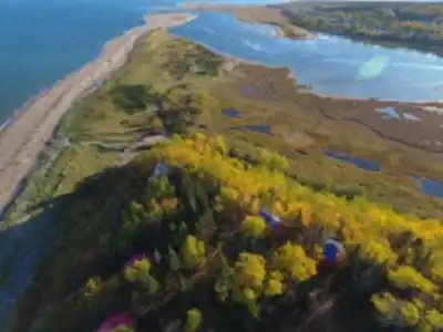
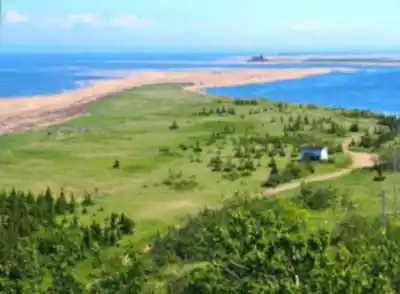
The Sentier Pédestre de Portneuf-sur-Mer is a hiking trail located in the village of Portneuf-sur-Mer, in the Duplessis region of Quebec. Sitting along the north shore of the St. Lawrence, this trail offers walkers a chance to connect with the coastal landscape that defines this stretch of the Lower North Shore — a place where the river is so wide it feels like the open sea.
The Setting
Portneuf-sur-Mer is a small, quiet community tucked between the boreal forest and the St. Lawrence estuary. The trail here reflects that duality — you're never far from either the treeline or the water. The landscape is shaped by the tidal influence of the St. Lawrence, and the shoreline environment gives the hike a character you won't find on inland trails. The light, the smell of salt and spruce, and the sounds of shorebirds all contribute to an experience that feels distinctly coastal.
The Duplessis region as a whole is one of Quebec's least-visited and most underrated outdoor destinations. Portneuf-sur-Mer sits at the western edge of this territory, making it one of the more accessible entry points for travellers coming from the Charlevoix or Haute-Côte-Nord areas.
What to Expect on the Trail
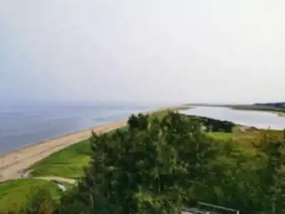
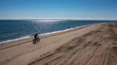
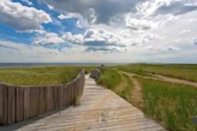
The Sentier Pédestre de Portneuf-sur-Mer is well suited to hikers looking for a relaxed outing in a scenic coastal environment. The terrain follows the natural contours of the shoreline and surrounding boreal landscape, offering views of the St. Lawrence that are hard to beat anywhere along this part of the coast.
The trail surface is typical of North Shore hiking — expect a mix of packed earth, roots, and sections that can get soft or muddy after rain. Footwear with some grip and ankle support is always a good idea, especially if you're planning to explore closer to the water's edge where the ground can be uneven and wet.
The pace here is unhurried. This isn't a trail that demands athletic performance — it rewards those who slow down, look around, and take in the surroundings. Bring binoculars if you have them. The estuary is a significant migration corridor, and birdwatching along the shore can be genuinely excellent depending on the season.
Wildlife and Natural Environment
The boreal forest framing the trail is home to the species you'd expect in this part of Quebec — black spruce, balsam fir, and white birch dominate the canopy. The understory is dense in places, with mosses and lichens covering the forest floor in the way that's characteristic of the North Shore's humid, cool climate.
The coastal edge of the trail is where things get interesting from a wildlife perspective. The St. Lawrence estuary at this latitude supports a rich marine and avian ecosystem. Depending on when you visit, you may spot various species of ducks, shorebirds, and wading birds working the tidal flats. The estuary is also known for marine mammals, and while sightings from shore are never guaranteed, they're not unusual either.
Getting There
Portneuf-sur-Mer is accessible by road via Route 138, which runs along the north shore of the St. Lawrence. The village is small, and the trailhead is easy to locate once you're in the area. Parking is available locally, and the community is welcoming to visitors.
If you're making a longer trip of it, the Duplessis region has plenty to offer beyond this single trail. The North Shore is the kind of place that rewards slow travel — taking the time to stop in small communities, explore the coastline, and get a feel for a part of Quebec that most people never see.
Good to Know
- Location: Portneuf-sur-Mer, Duplessis region, Quebec
- Terrain: Coastal and boreal forest, mix of packed earth and natural surfaces
- Access: Via Route 138 along the north shore of the St. Lawrence
- Best footwear: Trail shoes or light hiking boots with grip
- Highlights: St. Lawrence estuary views, boreal forest, coastal birdwatching
- Atmosphere: Quiet, unhurried, well off the beaten path
The Sentier Pédestre de Portneuf-sur-Mer is the kind of trail that suits anyone who appreciates a genuine North Shore experience — coastal air, boreal forest, and the wide, powerful presence of the St. Lawrence stretching out to the horizon.
Recommended gear for this trail


Ready to go?
Everything you need to know before you goStarting Point
To get to the trailhead of the Sentier Pédestre De Portneuf-sur-mer, you must go to the municipality of Portneuf-sur-mer.
When?
How much?
- Hiking shoes Essential
- → Salomon Elixir Tour Mid WP · 203.38 $
- Layered clothing Essential
- Rain jacket Essential
- Trekking poles
- → Black Diamond Trail Ergo Cork · 69.99 $
- Headlamp
- → Petzl Actik Core 625 · 103.95 $
FAQ - Frequently asked questions
Everything you need to knowThe Essential Hiking Checklist
Everything you need for your next hike. Bilingual, printable, 1 page.
Download the free checklistSimilar hikes nearby
Discover other trails you might enjoy

Parc National D'anticosti
North Shore

Réserve de parc national de l'Archipel-de-Mingan
North Shore

Mont Groulx
North Shore

Cascades De Rivière-au-tonnerre
North Shore

Sentier De La Mine Cap Feldspath
North Shore

Chutes Manitou
North Shore
Hiking near Quebec City
40 trails to explore ~258 km away
We work hard to provide the most up-to-date and error-free data possible. If something seems incorrect, let us know! Your contribution helps the whole community.
Hikers' opinions