

Ready to explore Parc National De L'île-bonaventure-et-du-rocher-percé? Here's everything you need to know before you go!
Discover the trail
Available trails
| Trails | Distance | Elevation | Duration | Difficulty | GPX |
|---|---|---|---|---|---|
| 8.2 km | 300 m | 2h30 | Intermediate | ||
| 4.7 km | 75 m | 1h30 | Intermediate | ||
| 2.8 km | 135 m | 50min | Intermediate | ||
| 3.5 km | 120 m | 58min | Intermediate | ||
| 3.7 km | 90 m | 58min | Intermediate |
Trail description
{
"section_to_update": "No major corrections needed in description body. Content accurately reflects island and coastal elements. However, add clarification about the 4 named trails.",
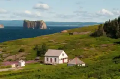
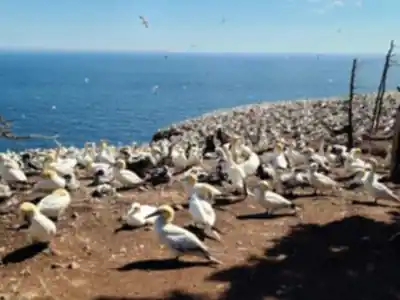
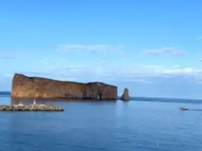
"added_content": "The park's main hiking sector on Île-Bonaventure features 4 named trails—Des Mousses, des Colonies, du Roy, and Paget—each offering unique perspectives of the Northern Gannet colony and the iconic Rocher Percé rock formation visible from the island."
}
Services and amenities
This information may vary by season.
Recommended gear for this trail


Ready to go?
Everything you need to know before you goStarting Point
To access the hiking trails, head to the main entrance located at 4 Rue du Quai, Percé, QC G0C 2L0. From there, you can take a ferry to reach the island where the trails begin. There are no alternative trailheads on the island itself; all visitors must start from this point.
When?
Tuesday: 9:00 AM – 5:00 PM
Wednesday: 9:00 AM – 5:00 PM
Thursday: 9:00 AM – 5:00 PM
Friday: 9:00 AM – 5:00 PM
Saturday: 9:00 AM – 5:00 PM
Sunday: 9:00 AM – 5:00 PM
How much?
- Hiking shoes Essential
- → Salomon Elixir Tour Mid WP · 203.38 $
- Layered clothing Essential
- Rain jacket Essential
- Trekking poles
- → Black Diamond Trail Ergo Cork · 69.99 $
- Headlamp
- → Petzl Actik Core 625 · 103.95 $
FAQ - Frequently asked questions
Everything you need to knowTuesday: 9:00 AM – 5:00 PM
Wednesday: 9:00 AM – 5:00 PM
Thursday: 9:00 AM – 5:00 PM
Friday: 9:00 AM – 5:00 PM
Saturday: 9:00 AM – 5:00 PM
Sunday: 9:00 AM – 5:00 PM
The Essential Hiking Checklist
Everything you need for your next hike. Bilingual, printable, 1 page.
Download the free checklistSimilar hikes nearby
Discover other trails you might enjoy

Parc National De La Gaspésie
Gaspésie - Îles-de-la-Madeleine

Plage Haldimand
Gaspésie - Îles-de-la-Madeleine

Réserve Faunique De Matane
Gaspésie - Îles-de-la-Madeleine

Mont Saint-Pierre
Gaspésie - Îles-de-la-Madeleine
Mont Vallieres-de-Saint-Real
Gaspésie - Îles-de-la-Madeleine

Parc National Du Canada Forillon
Gaspésie - Îles-de-la-Madeleine
Hiking near Charlottetown
11 trails to explore ~267 km away
We work hard to provide the most up-to-date and error-free data possible. If something seems incorrect, let us know! Your contribution helps the whole community.
Hikers' opinions