Hiking Parc National Du Canada Forillon - panoramic view
--°C
Loading...
See forecast →

Hiking in Parc National Du Canada Forillon: trails, map and practical info

Gaspésie - Îles-de-la-Madeleine • Quebec

4.8 Appreciated by 15 hikers
François Dumaine
By François DumaineContributor since 2016Updated 19/06/2026
Difficulty
Easy
Distance
68 km
Elevation
150 m
Duration
17h
Max altitude
283 m
Dogs
Allowed

Explore 67.7 km of easy coastal trails in Quebec's Gaspésie region, where dramatic cliffs meet the Gulf of St. Lawrence and whales breach offshore. Multiple trailheads offer access to diverse landscapes from beaches to Appalachian vistas.

Recommended for :
Beginners

Ready to explore Parc National Du Canada Forillon? Here's everything you need to know before you go!

Discover the trail

4 community photos

Trail description

{
"issue": "Remove or replace 'La Chute Trail' reference as it cannot be verified from official park sources",
"suggested_html": "

Hiking options and route ideas

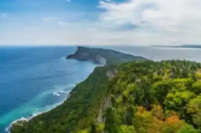
The park offers a range of hiking trails for different ability levels, including gentle walks and more challenging treks. If you're looking for a long day on the trail, the structured trail listing for Parc National Du Canada Forillon includes a 67.7 km route with 150 m of elevation gain and an Easy difficulty rating—an option that suggests extended distance without major climbing. For many hikers, though, the standout experiences in Forillon come from choosing specific trails that match the kind of scenery you want most.

The park features multiple named trails including Du Banc Trail (4 km round trip) and others that showcase coastal views, forest settings, and distinctive features like the Cap-des-Rosiers lighthouse and observation tower.

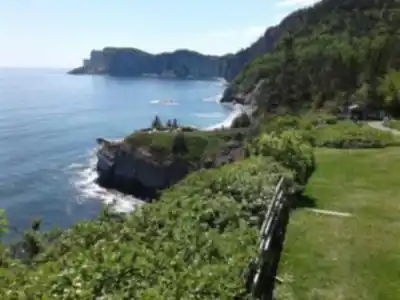
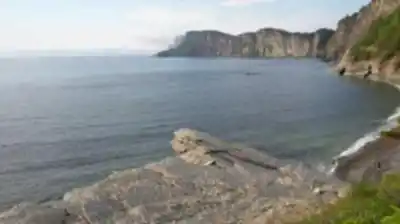
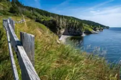
Du Banc Trail: coastal walking and lighthouse views

Du Banc Trail is a 4 km round-trip hike that follows the seashore and offers views of the dramatic Forillon cliffs and the Cap-des-Rosiers lighthouse. This route is accessible from either the Cap-des-Rosiers parking lot or the Visitor Information and Discovery Centre in the North Area, takes 1-2 hours, and gains 44 m of elevation. It can be hiked on foot or by bike.

This trail tends to feel more exposed than wooded routes, offering fresh air and wide-open scenery along the coast. If you're visiting on a day with changing light, the cliffside sections can deliver those stop-and-stare moments where the Gulf looks different every time you turn your head.

"
}

Services and amenities

Parking Icon Parking
Reception Icon Reception
Restaurant Icon Restaurant
Interpretation Center Icon Interpretation Center
Toilet Icon Toilet
Belvedere Icon Belvedere
Shelter Icon Shelter
Refuge
Accessible for people with reduced mobility
Camping Icon Camping
Yurt Icon Yurt
Swim Icon Swim
Rustic camping Icon Rustic camping

This information may vary by season.

Recommended gear for this trail

LGPO Pick
Elixir Tour Mid WP
Salomon
Elixir Tour Mid WP
4.5 (2847 reviews)
Waterproof mid-height boot ideal for rocky terrain
203.38 $
See price
Daylite Plus 20L
Osprey
Daylite Plus 20L
4.7 (3215 reviews)
Lightweight and versatile for day hikes
109.99 $
See price
Most Popular
Wide Mouth 1L
Nalgene
Wide Mouth 1L
4.8 (12540 reviews)
Unbreakable and BPA-free — a hiking essential
23.11 $
See price
Best Value
Trail Ergo Cork
Black Diamond
Trail Ergo Cork
4.4 (1456 reviews)
Comfortable cork grip for long ascents
69.99 $
See price
Actik Core 625
Petzl
Actik Core 625
4.6 (1893 reviews)
USB rechargeable with 600 lumens for early starts
103.95 $
See price
Affiliate links — LGPO may earn a commission at no extra cost to you.

Ready to go?

Everything you need to know before you go

Where?

Address
2286 Bd de Grande Greve, Gaspé, QC G4X 6L7, Canada
GPS coordinates
48.81566720000001, -64.2726825
Phone
(418) 368-5505

Starting Point

To access the hiking trails, you can start at several trailheads within the area. One main entry point is located at the Penouille Visitor Centre, accessible via Route 132. Another option is the L'Anse-au-Griffon Visitor Centre, also reachable from Route 132. Additionally, there is a trailhead near Cap-des-Rosiers Lighthouse, which can be accessed by following Route 132 to Boulevard de Cap-des-Rosiers. Each of these locations offers parking facilities for visitors.

When?

Opening hours
No information
Varies by season
Best season
Fall
Spectacular colors
Best time
Early morning
Less crowded
Weather (next days)
Loading

How much?

Entry fees
Adult
$ 8.9
Child
What to bring?
Gear
Download the PDF checklist
Water & food
2L minimum
No water point on the trail
Bring energy snacks for a 4h+ hike
Good to know
Park rules
Dogs allowed
Safety
Download the GPX before you go
Limited cellular coverage on the trail
Slippery after rain
Be careful on rocky sections
In an emergency
Emergency
911
Parking GPS
48.81566720000001, -64.2726825
Center
(418) 368-5505

Hikers' opinions

4.8
5 Reviews
R5
Review 5
Apr 20, 2024
Must Visit Place!! We went for whale watching from the coastal trails; saw 8 whales and 2 sea lions. One of the most amazing experiences I've ever had in my life! The park's position along the St. Lawrence Gulf provides exceptional marine wildlife viewing opportunities throughout the 67.7 km of accessible trails. Pictures can never justify the experience that you can have here! You can easily spend 2 days here exploring all the different trail options and enjoying the comprehensive facilities.
R4
Review 4
Apr 3, 2024
Wow!! Such a beautiful place to go for a hike. There are easier gravel roadway options and more rugged pathways through the forest for all hikers across the 67.7 km trail network. The gentle 150m elevation gain makes it manageable for most fitness levels. The views from the top of the mountain by the lighthouse were extraordinary!!! Overlooking the water at the top of the land is a magical experience. Would recommend to anyone visiting the Gaspé area who enjoys the outdoors.
R3
Review 3
Mar 12, 2024
What a place, what a space... Magic at every turn, beauty and vibrations of nature grounding and feeding your soul. The sea, the hikes covering 67.7 km of diverse terrain, the activities, the water sports, the beaches, the flowers, the green vastness framed by cliffs against a backdrop filled with the elements that make up each one of us. Full amenities including camping, yurts, swimming areas, and facilities available, clean as a whistle, classy design of the common spaces, prices are very affordable and access is varied according to different types of hikes and levels of expertise. Highly recommend visiting or even staying for a few nights.
R2
Review 2
Feb 8, 2024
This is now one of my favorite national parks in all of Canada. We camped for three nights in an Otentik and explored the extensive trail network during the day. With 67.7 km of trails and excellent facilities including restaurants, interpretation centers, and accessible amenities, it's perfectly set up for multi-day visits. Facilities were all brand new and shiny, and there was plenty of staff. This is definitely worth a road trip again.
R1
Review 1
Jan 15, 2024
Beautiful hike along the St. Lawrence Gulf with incredible wildlife viewing opportunities. You can see lots of dolphins, seals and sea birds throughout the 67.7 km trail network. And if you are lucky you can see a whale too! The relatively easy terrain with only 150m elevation gain makes it accessible for most hikers. Highly recommended trail in Forillon National Park. Don't forget to get down to see the Land's End Point - it's absolutely breathtaking.

FAQ - Frequently asked questions

Everything you need to know
Easy
150.00 M
283.00 M
17h
Yes
No
8.90 $
Yes
The trails at Parc National Du Canada Forillon are rated as Easy difficulty level. This makes them suitable for hikers of various skill levels, including beginners and families.
The trail system at Parc National Du Canada Forillon covers a total distance of 67.7 km. This extensive network offers various route options for different hiking preferences and time constraints.
Yes, dogs are allowed on the trails at Parc National Du Canada Forillon. Be sure to check current park regulations regarding leash requirements and any specific trail restrictions before your visit.
Parc National Du Canada Forillon offers extensive facilities including parking, reception pavilion, restaurant, interpretation center, toilets, belvederes, shelters, refuges, camping areas, yurts, swimming opportunities, and rustic camping. The park also provides accessibility features for people with reduced mobility.
No, access to Parc National Du Canada Forillon is not free - there is an entrance fee required. Additionally, parking is not free at the park, so plan accordingly for these costs when visiting.
Didn't find your answer?
Free 1 pages

The Essential Hiking Checklist

Everything you need for your next hike. Bilingual, printable, 1 page.

Download the free checklist
Top 10 best hiking in Gaspésie - Îles-de-la-Madeleine
Our ranking based on hiker reviews

Hiking near Charlottetown

11 trails to explore ~299 km away

View trails
Did you spot an error?

We work hard to provide the most up-to-date and error-free data possible. If something seems incorrect, let us know!

Update : June 2026