
Our favorite hikes in Gaspésie - Îles-de-la-Madeleine
Discover EPIC trails Gaspésie - Îles-de-la-Madeleine
Why hike in in Gaspésie - Îles-de-la-Madeleine?
Our favorites

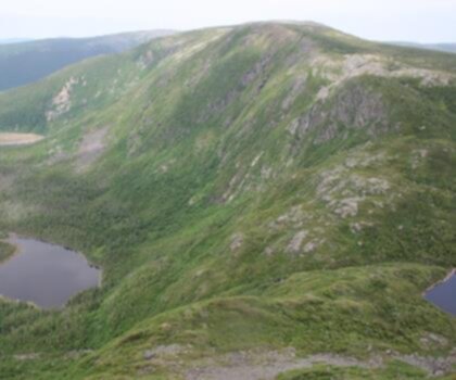
Mont Saint-Pierre
Gaspésie - Îles-de-la-Madeleine
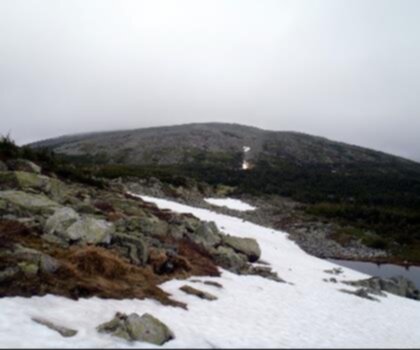
Mont Saint-Pierre
Gaspésie - Îles-de-la-Madeleine

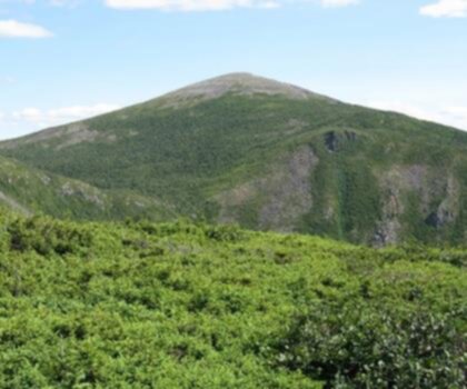
Parc National De La Gaspésie
Gaspésie - Îles-de-la-Madeleine
All trails
34 trails


Featured parks in the region
Must-visit for your hikes in Gaspésie - Îles-de-la-Madeleine

Le Parc Régional De La Seigneurie Du Lac Matapédia
Regional Park
Parc National De L'île-bonaventure-et-du-rocher-percé
National Park
Parc National De Miguasha
National Park
Parc National Du Canada Forillon
National Park
Parc Régional De Val-d'irène
Regional Park
Parc National De La Gaspésie
National ParkWhy hike in in Gaspésie - Îles-de-la-Madeleine?
The Gaspésie - Îles-de-la-Madeleine region stands as one of Quebec's most spectacular wilderness destinations, where rugged mountains meet pristine coastlines in an unforgettable display of natural beauty. This remote corner of eastern Canada offers hikers an extraordinary blend of maritime landscapes, ancient mountain ranges, and unique island adventures that create some of the most diverse hiking experiences in the province.
Why Hike in Gaspésie - Îles-de-la-Madeleine
The Gaspésie Peninsula boasts the highest peaks in Quebec south of the Arctic, with the Chic-Choc Mountains rising dramatically from the sea. These ancient Appalachian summits harbor rare alpine tundra ecosystems and offer breathtaking panoramic views across the Gulf of St. Lawrence. The region's unique geography creates a remarkable diversity of landscapes, from dense boreal forests and cascading waterfalls to windswept coastal cliffs and pristine beaches.
The Îles-de-la-Madeleine (Magdalen Islands) add another dimension to the region's hiking appeal, featuring distinctive red sandstone cliffs, expansive dunes, and coastal trails that showcase the raw power of the Atlantic Ocean. The islands' isolation has preserved unique ecosystems and created hiking experiences unlike anywhere else in Canada.
Essential Hiking Destinations
The region offers numerous world-class hiking opportunities that showcase its diverse terrain. Forillon National Park provides spectacular coastal hiking along towering limestone cliffs, where trails lead to dramatic viewpoints overlooking the Gulf of St. Lawrence. Gaspésie National Park features challenging mountain ascents through pristine wilderness, including routes to some of Quebec's highest summits.
The International Appalachian Trail traverses the region, offering multi-day hiking adventures through remote mountain terrain. On the Magdalen Islands, coastal trails provide unique opportunities to explore red sandstone formations, hidden coves, and expansive beach systems that create unforgettable hiking memories.
Diverse Trail Difficulties
Gaspésie - Îles-de-la-Madeleine hiking trails cater to all experience levels. Gentle coastal walks and interpretive trails offer accessible options for families and casual hikers, while challenging mountain ascents and multi-day backcountry routes satisfy experienced adventurers seeking serious wilderness challenges. The region's varied topography ensures that every hiker can find trails matching their abilities and interests.
Beyond Hiking Adventures
The region's outdoor recreation extends far beyond hiking trails. Sea kayaking along dramatic coastlines provides unique perspectives of towering cliffs and hidden sea caves. Wildlife watching opportunities abound, with chances to spot caribou, black bears, and diverse seabird colonies. Fishing enthusiasts can pursue salmon in pristine rivers, while winter brings excellent opportunities for snowshoeing and cross-country skiing through snow-covered forests.
Planning Your Visit
The optimal hiking season runs from June through October, when trails are snow-free and weather conditions are most favorable. Summer offers the warmest temperatures and longest daylight hours, while fall provides spectacular foliage displays. Due to the region's maritime climate and exposed mountain terrain, hikers should pack layered clothing, waterproof gear, and sturdy hiking boots. The remote nature of many trails requires careful trip planning, adequate supplies, and proper navigation equipment for safe wilderness exploration.
What hikers say
"En tant que retraité actif, j'ai beaucoup apprécié la Gaspésie. Les sentiers offrent une belle variété de difficultés, ce qui permet de choisir en fonction de son envie du moment. Les paysages, avec leur richesse en faune et en flore, rendent chaque randonnée mémorable. Une belle région à explorer lentement!"
"Gaspésie is a lovely destination for hiking, but be prepared for unpredictable weather! On some days, we faced sudden rain showers. The trails are well-marked, which is helpful. While the scenery is stunning, I felt certain popular trails were a bit crowded. Overall, it's a beautiful area worthy of exploration if you pick your days wisely."
"Cette région est un paradis pour les amateurs de photographie. Les contrastes entre les montagnes verdoyantes et les eaux turquoise des plages des Îles-de-la-Madeleine offrent des possibilités infinies pour capturer la beauté naturelle. J'ai été ébloui par la sérénité des lieux et la diversité des sentiers."
"J'ai visité la Gaspésie avec mes enfants et, bien que certains sentiers soient adaptés aux familles, d'autres sont plus exigeants. Il est essentiel de bien se renseigner à l'avance. La région est belle et sauvage, mais elle peut être difficile pour les jeunes randonneurs. Cependant, la beauté des paysages compense ces défis!"
The Essential Hiking Checklist
Everything you need for your next hike. Bilingual, printable, 1 page.
Download the free checklistExplore other regions
Discover hikes in neighboring regions


Explore by starting city
Find trails near your cityFrequently Asked Questions
Quickly find answers to your questions