

Ready to explore Parc Régional des Chutes Monte-à-Peine et des Dalles? Here's everything you need to know before you go!
Discover the trail

Trail description
Description
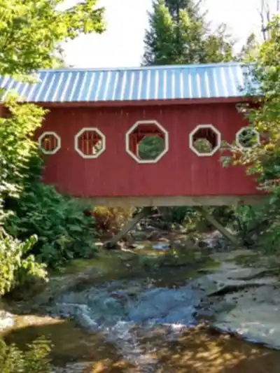
Parc Régional des Chutes Monte-à-Peine et des Dalles (Entrée Sainte-Béatrix) sits in the heart of Lanaudière and feels like the kind of place you stumble onto once and then want to bring everyone back to. It’s a park built around moving water and forest—expect the constant soundtrack of a river and the rush of waterfalls, plus that fresh, resin-y pine scent that hits as soon as you step onto the trail.
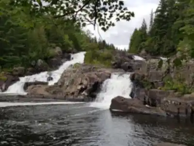
The big draw here is the park’s waterfall scenery, especially the impressive Chutes Monte-à-Peine, which shows up as a focal point of the visit and a natural “turnaround-and-take-a-photo” spot. Around it, the park offers a network of well-maintained trails that let you choose anything from an easy outing to a more demanding hike, all while staying immersed in forest and river landscapes.
What the hike feels like
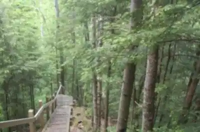
From Entrée Sainte-Béatrix, the paths are described as well maintained, and you’ll feel that in how the hike flows—less time watching your feet for hazards, more time looking around. The trails wind through lush forest and run alongside serene rivers, so the experience is often a mix of shade, cool air near the water, and frequent natural stopping points where you’ll want to pause and listen.
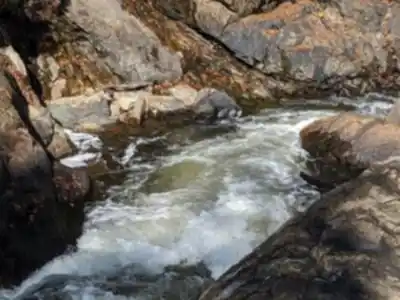
Terrain-wise, you can expect typical forest trail underfoot (packed earth and natural tread), with sections that bring you close to the river corridor. Near waterfalls, the air can feel cooler and more humid, and the sound of the cascade tends to grow as you approach—one of the most satisfying “you’re almost there” cues you can get on a hike. Because the park is known for its waterfalls, you’ll likely find that the highlights come in bursts: quiet forest walking followed by a dramatic water feature that makes the whole area feel alive.
The park also mentions elevated viewpoints on some trails. These are the routes that add a bit more effort, but they pay off with broader looks at the surrounding beauty of Lanaudière. If you’re deciding how to plan your outing, it’s worth thinking about whether you want a mostly riverside walk (steady, scenic, relaxing) or to include a climb toward viewpoints (more effort, more expansive views).
Waterfalls, rivers, and viewpoints
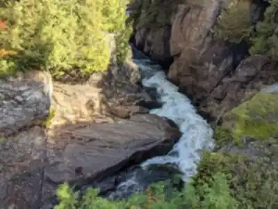
The waterfalls here aren’t just a single photo-op—they’re part of what defines the visit. The standout is Chutes Monte-à-Peine, described as an impressive waterfall and a picturesque backdrop for your adventure. As you move through the park, the landscape keeps tying back to water: trails that follow the river’s edge, places where you can hear cascades before you see them, and natural clearings that frame the falls through trees.
For hikers who like variety, this is where the park shines. Forest sections give you that sheltered, green tunnel feeling, then the trail opens toward the river where you get more light and motion in the scenery. On the more challenging options, the elevated viewpoints add a different perspective—less about the close-up drama of rushing water and more about taking in the bigger sweep of Lanaudière from above.
Wildlife and what to look for
The park’s trails offer “plenty of opportunities to spot local wildlife.” That typically means it’s worth slowing down, especially in the quieter stretches away from the loudest water. Keep your eyes moving along the forest edge and across the river corridor, and take a few moments to stand still now and then—wildlife sightings are often about patience more than distance.
If you’re bringing a camera, you’ll have lots to work with even without wildlife: the park calls the vistas “Instagram-worthy,” and between waterfalls, river views, and elevated lookouts, you’ll have a steady rotation of scenery that changes as you move.
Choosing a trail for your group
This park works well for mixed groups because it’s explicitly described as having “a trail suited for every level.” If you’re hiking with newer walkers, aim for a leisurely pace and focus on the riverside and waterfall experience—shorter breaks at the scenic points can make the day feel full without needing a big push. If you’re more experienced, prioritize routes that include the elevated viewpoints for a bit more challenge and a bigger visual payoff.
Even if you don’t plan an ambitious hike, the setting makes simple walking feel rewarding: the combination of lush forest, water features, and maintained paths means you can spend more energy enjoying the surroundings and less managing rough conditions.
Season-by-season: what changes through the year
The park is open year-round, and the experience shifts noticeably with the seasons.
- Spring and summer: Wildflowers blanket the ground, and the forest feels vivid and full. With water as a main feature of the park, these seasons tend to feel especially refreshing—cool air near the river and the sound of cascading water as you hike.
- Autumn: The landscape turns into a tapestry of fiery reds and oranges. This is a great time to prioritize viewpoints, since broader looks over the forest canopy really show off the fall colour.
- Winter: Snow-covered trails create a quieter, calmer atmosphere, and the park is described as being perfect for snowshoeing. Expect the same trail network to feel more serene, with the forest muffled by snow.
Facilities at Entrée Sainte-Béatrix
Entrée Sainte-Béatrix is set up to make a day visit comfortable. You’ll find picnic areas that are ideal for a mid-hike break or a relaxed lunch surrounded by trees and the sound of water in the distance. Planning a picnic is a good way to slow the pace and make the visit feel less rushed—especially if you’re hiking with a group that likes to stop often for photos or snacks.
The park also suggests picking up a map from the visitor center to guide your exploration. Even on well-maintained paths, having a map helps you link together waterfalls, riverside sections, and any viewpoint routes you want to include, so you don’t miss the park’s standout features.
What to bring
This park rewards being prepared, especially since the main attractions involve water and forest terrain. The essentials listed for a comfortable day here are:
- Sturdy hiking boots for natural trail surfaces and potentially damp areas near waterfalls and rivers
- Water, even if you’re planning a shorter visit
- Snacks (or a full picnic if you want to use the picnic areas)
- A map from the visitor center to help plan your route and choose trails that match your energy level
If you’re visiting specifically for photos, keep your camera handy rather than buried in a pack—the scenery comes in waves, and the best moments often appear suddenly as the trail rounds toward a waterfall or opens to a river view.
How to plan your day
This park works well as a day trip, especially if you want a nature-heavy outing without needing complicated logistics: arrive at Entrée Sainte-Béatrix, choose a route that matches your group’s experience, and build in time for waterfall stops and viewpoints. If you’re staying longer in Lanaudière, it also fits nicely as a repeatable destination—one visit focused on the Chutes Monte-à-Peine area and riverside trails, another focused on the more challenging routes that reach elevated viewpoints.
No matter how you structure it, the signature of Parc Régional des Chutes Monte-à-Peine et des Dalles is that constant connection to water—cascades, rivers, and the calm pockets of forest in between—paired with trails that make it easy to focus on the experience rather than the footing.
Recommended gear for this trail


Ready to go?
Everything you need to know before you goStarting Point
To access the hiking trails, head to the Entrée Sainte-Béatrix. The parking lot and trailhead are located at 396 rue du Parc, Sainte-Béatrix, QC J0K 1Y0.
When?
How much?
- Hiking shoes Essential
- → Salomon Elixir Tour Mid WP · 203.38 $
- Layered clothing Essential
- Rain jacket Essential
- Trekking poles
- → Black Diamond Trail Ergo Cork · 69.99 $
- Headlamp
- → Petzl Actik Core 625 · 103.95 $
FAQ - Frequently asked questions
Everything you need to knowThe Essential Hiking Checklist
Everything you need for your next hike. Bilingual, printable, 1 page.
Download the free checklistSimilar hikes nearby
Discover other trails you might enjoy

Mont Sourire
Lanaudière

Parc Régional De La Forêt Ouareau
Lanaudière

Parc Des Chutes Dorwin
Lanaudière

Parc des Cascades
Lanaudière

Mont Ouareau
Lanaudière

La Montagne Noire
Lanaudière
Hiking near Laval
97 trails to explore ~67 km away
We work hard to provide the most up-to-date and error-free data possible. If something seems incorrect, let us know! Your contribution helps the whole community.
Hikers' opinions