

Ready to explore Ski Montcalm? Here's everything you need to know before you go!
Discover the trail
Available trails
| Trails | Distance | Elevation | Duration | Difficulty | GPX |
|---|---|---|---|---|---|
| 1.8 km | 0 m | 24min | GPX |
Trail description
Description
Ski Montcalm sits quietly in the Lanaudière region, about an hour from Montreal, offering 13.5 kilometers of trails that wind through forested hills with 200 meters of elevation gain. What makes this place work so well for hiking is how the terrain naturally flows—rolling hills covered in mixed forest create a landscape that feels both accessible and engaging, whether you're out for a quick afternoon walk or planning a full four-hour adventure.
The trail network here adapts to different hiking styles and energy levels. You can stick to gentler routes that meander through the woods, or link together sections that climb and descend through the hills for a more sustained workout. Because this is primarily a ski area, the trails were designed with varied terrain in mind, which translates into interesting hiking with enough elevation change to keep things dynamic without being overwhelming.
What the hiking experience feels like
Walking at Ski Montcalm means moving through a landscape that shifts gradually as you gain and lose elevation. The forested hills create natural rhythm—you'll climb steadily through sections of mixed woodland, then descend into small valleys before the next gentle ascent begins. This rolling terrain gives you a sense of progress and variety that flat forest trails often lack.
The trail surface varies depending on the season and recent weather. In summer, you'll walk on packed earth and forest duff, with occasional rocky sections where the trail crosses natural drainage areas. During autumn, fallen leaves create a softer surface but can hide roots and rocks, making hiking boots a smart choice. Winter transforms the experience completely—snow-covered trails become quieter and more serene, though they require appropriate footwear for traction.
One practical advantage here is the flexibility the trail network provides. You're not locked into a single out-and-back route or committed to completing a long loop. The interconnected trails let you adjust your plans as you go, shortening your hike if weather moves in or extending it if everyone's feeling strong and wants more time in the woods.
Terrain and trail conditions
The 200 meters of elevation gain spreads out over the 13.5-kilometer trail system, creating moderate climbs rather than steep, sustained ascents. Most elevation changes feel gradual, though some sections will get your heart rate up, especially if you're carrying a pack or hiking with kids who need encouragement on the uphill stretches.
The forested terrain includes sections of mature mixed woodland—maple, birch, and pine—with understory that varies from open forest floor to areas with more dense shrub growth. Trail width varies too; some sections feel like wide forest paths while others narrow to single track that winds between trees. This variety keeps the hiking interesting and gives you different perspectives on the surrounding landscape.
Drainage is generally good throughout the trail system, but expect muddy conditions in spring and after heavy rain. The rolling topography means water moves through the area rather than pooling, but low-lying sections can stay soft longer than the ridgeline trails.
Seasonal scenery and viewpoints
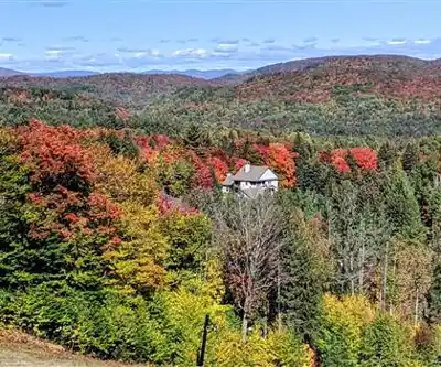
While much of your hiking happens within the forest canopy, the rolling hills create natural openings where the landscape expands and you get broader views of the surrounding Lanaudière countryside. These viewpoints aren't dramatic overlooks, but they provide welcome breaks and photo opportunities, especially when seasonal changes make the forest particularly striking.
Autumn brings the most dramatic scenery, when the mixed hardwood forest explodes in color. The maples and birches create a canopy of red, orange, and yellow that filters sunlight and makes even familiar trail sections feel transformed. Summer hiking means walking through green forest with the fresh scent of pine, particularly noticeable on warm days when the trees release their oils into the air.
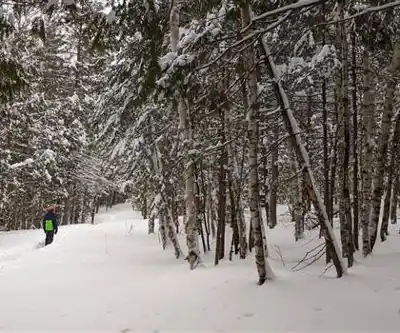
Winter hiking here offers a completely different mood. Snow-covered branches create a quieter, more intimate atmosphere, and the rolling hills become more pronounced when you can see their shapes through bare deciduous trees. The evergreens provide structure and color against the white landscape, making this a rewarding season for photography.
Wildlife and forest atmosphere
The mixed forest habitat supports a variety of wildlife that you might encounter if you move quietly and pay attention to your surroundings. Deer are common in this area and often move through the woods in early morning or late afternoon. You'll increase your chances of wildlife sightings by pausing occasionally, keeping conversation low, and looking ahead before rounding corners or cresting small hills.
Bird activity varies by season but is generally strong throughout the year. During spring and summer, the forest canopy comes alive with songbirds, while autumn migration can bring unexpected species through the area. Winter birding focuses on year-round residents like chickadees, nuthatches, and woodpeckers that remain active even in cold weather.
The forest atmosphere changes significantly with weather and season. On calm days, you'll notice how quiet the woods can be, with only the sound of your footsteps and occasional bird calls. When wind moves through the trees, the forest becomes more dynamic, with the sound of branches and leaves creating a backdrop that makes the hiking feel more immersive.
Planning your visit and route options
The four-hour duration for the full trail system assumes a moderate pace with breaks for scenery and snacks. You can easily spend less time here by choosing shorter route combinations, or extend your visit by taking longer breaks and exploring different trail connections. The well-marked trail network makes navigation straightforward, though checking trail maps before you start helps you plan a route that matches your group's goals and energy level.
Parking is ample and rarely an issue, even on busy weekend days. This takes pressure off your timing and lets you focus on the hiking rather than worrying about finding a spot. The trailhead facilities are basic but functional, with clear trail markers that make getting started simple.
Before heading out, check Ski Montcalm's website for current trail conditions and any seasonal events that might affect your visit. This is particularly important during transition seasons when trail conditions can change quickly, or in winter when some trails might be prioritized for skiing.
What to bring and seasonal considerations
Hiking boots make a significant difference here, especially on the rolling terrain where good traction and ankle support help with comfort and confidence. The varied trail surface and seasonal conditions—from muddy spring trails to leaf-covered autumn paths to potentially icy winter sections—make sturdy footwear worthwhile.
Pack snacks and water for the full route, particularly if you're hiking with family or a group with mixed experience levels. The moderate elevation gain can be more tiring than expected, especially for newer hikers, and having food and drinks available makes breaks more enjoyable and helps maintain energy for the full distance.
A camera is worth bringing year-round, as the seasonal changes and occasional viewpoints provide good photo opportunities. The lighting in the forest can be particularly striking during autumn and winter when the sun angle is lower and creates more dramatic shadows and highlights.
Ski Montcalm works as a hiking destination precisely because it offers variety within a manageable scope—enough terrain and distance to feel like a real outdoor adventure, but accessible enough for a range of hiking experience levels and seasonal conditions.
Recommended gear for this trail


Ready to go?
Everything you need to know before you goStarting Point
To get to the cross-country ski trails at ski montcalm, one must take Route 158 and go to Chemin du Lac-des-Écorces. Then, one must continue on Lac-des-Écorces Road to the park entrance.
When?
How much?
- Hiking shoes Essential
- → Salomon Elixir Tour Mid WP · 203.38 $
- Layered clothing Essential
- Rain jacket Essential
- Trekking poles
- → Black Diamond Trail Ergo Cork · 69.99 $
- Headlamp
- → Petzl Actik Core 625 · 103.95 $
FAQ - Frequently asked questions
Everything you need to knowThe Essential Hiking Checklist
Everything you need for your next hike. Bilingual, printable, 1 page.
Download the free checklistSimilar hikes nearby
Discover other trails you might enjoy

Mont Sourire
Lanaudière

Parc Régional De La Forêt Ouareau
Lanaudière

Parc Des Chutes Dorwin
Lanaudière

Parc des Cascades
Lanaudière

La Montagne Noire
Lanaudière

Mont Ouareau
Lanaudière
Hiking near Laval
97 trails to explore ~49 km away
We work hard to provide the most up-to-date and error-free data possible. If something seems incorrect, let us know! Your contribution helps the whole community.
Hikers' opinions