

Ready to explore Parc Des Champs-de-bataille? Here's everything you need to know before you go!
Discover the trail


Trail description
Description
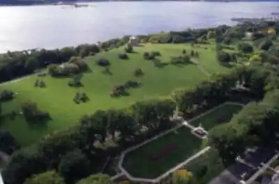
Parc des Champs-de-Bataille — better known to locals as the Plains of Abraham — is one of the most historically significant green spaces in Canada, and it happens to be a genuinely great place to walk, jog, and explore on foot. Sitting on the cliffs above the St. Lawrence River in the heart of Québec City, this national urban park blends open meadows, wooded paths, formal gardens, and sweeping river views into a single accessible destination that draws visitors year-round.
The park is managed by the National Battlefields Commission, a federal body that has overseen the site since 1908. That long history of stewardship shows — the grounds are well-maintained, clearly signed, and thoughtfully laid out for people who want to move through them on foot.
The Terrain
The landscape here is largely flat to gently rolling, which makes it accessible to just about everyone. The open grassy plains that give the park its name stretch across a wide plateau, offering long sightlines and a sense of openness that's rare in an urban environment. Along the cliff edges, the terrain drops sharply toward the river, and the views from these vantage points are genuinely impressive — you're looking out over the St. Lawrence from a considerable height, with Lévis visible on the opposite shore.
Wooded sections thread through parts of the park, providing shade and a quieter atmosphere away from the main open areas. The tree cover includes a mix of mature deciduous and coniferous species, and the canopy creates a noticeably different feel from the exposed meadows nearby. Paved paths, gravel trails, and grass routes all coexist here, so you can vary your surface depending on what you're after.
Walking and Exploring the Park
There's no single defined hiking trail with a fixed distance or loop — the park is more of an open network where you set your own route. You can wander freely across the plains, follow the cliff-edge promenade for river views, dip into the wooded sections, or connect through to the adjacent Battlefields Park Discovery Pavilion. The layout rewards exploration rather than a point-A-to-point-B approach.
The Martello towers are hard to miss as you move through the park — four of these cylindrical stone fortifications were built by the British in the early 19th century, and two of them are open to visitors seasonally. They serve as natural landmarks that help you orient yourself as you walk. The Joan of Arc Garden, located near the Laurier Avenue entrance, is a formal garden space worth a detour — it's well-kept and offers a different visual texture from the open plains.
The cliff-edge walk along the Grande-Allée side of the park is one of the most rewarding stretches. You get continuous views of the river and the south shore, and the path is wide enough to walk comfortably even when the park is busy. This section connects naturally to the area near the Citadelle of Québec, so it's easy to extend your outing into the fortifications district if you want more ground to cover.
What Makes This Place Stand Out
The combination of historical depth and genuine outdoor quality is what sets Parc des Champs-de-Bataille apart from other urban green spaces. You're walking across ground where one of the most consequential battles in North American history took place in 1759 — the confrontation between British forces under General Wolfe and French forces under the Marquis de Montcalm that effectively determined the future of New France. That context is present throughout the park without being overwhelming. Interpretive panels are placed at key points, and the Discovery Pavilion offers a deeper dive for those who want it, but you can also simply enjoy the space as a park without engaging with the history at all.
The scale of the open plains is also something you don't find in many city parks. There's genuine breathing room here — enough space that even on a busy weekend afternoon, you can find a quiet corner of the grounds to yourself. The combination of open sky, river views, and mature trees gives the park a variety of atmospheres within a compact area.
Practical Information
The park is located in the Capitale-Nationale region of Québec, within Québec City itself, making it one of the most accessible natural spaces in the province. There are multiple entry points along Grande-Allée, avenue Wolfe-Montcalm, and the cliff-side promenade. The grounds are open year-round, and in winter the park transforms into a popular cross-country skiing and snowshoeing destination — the same open terrain that makes it pleasant for walking in summer becomes a well-groomed trail network once snow arrives.
- Access: Multiple pedestrian entrances from surrounding streets; the park is walkable from the Old Québec fortifications and the Grande-Allée entertainment district
- Parking: Paid parking is available at the Discovery Pavilion and along surrounding streets
- Facilities: Washrooms, the Discovery Pavilion with exhibits and a café, picnic areas, and benches throughout
- Dogs: Dogs are welcome in the park on leash
- Accessibility: Paved and packed-gravel paths make much of the park accessible to strollers and mobility aids
- Admission: The park grounds are free to access; fees apply for entry to the Martello towers and Discovery Pavilion exhibits
When to Go
The park holds up well across all four seasons. Spring brings green-up early on the open plains and the Joan of Arc Garden comes into bloom. Summer is the busiest period — the open space hosts outdoor events and concerts, so if you're looking for a quieter experience, early mornings on weekdays are your best bet. Fall is particularly strong here: the mature trees in the wooded sections turn well, and the light on the river from the cliff edge on a clear October afternoon is hard to beat. Winter opens up a completely different use of the space, with groomed ski trails replacing the walking paths across the plains.
Whatever season brings you here, Parc des Champs-de-Bataille delivers a walking experience that's genuinely hard to replicate — open, historically layered, and right in the middle of one of Canada's most distinctive cities.
Recommended gear for this trail


Ready to go?
Everything you need to know before you goStarting Point
To access the hiking trails, you can start at several trailheads. One option is to head to the main parking lot located at 835 Wilfrid-Laurier Avenue, Quebec City, QC G1R 2L3. Another possible starting point is near the intersection of George VI Avenue and De Bernières Avenue, where additional parking is available. Both locations provide convenient access to the trails in the area.
When?
How much?
- Hiking shoes Essential
- → Salomon Elixir Tour Mid WP · 203.38 $
- Layered clothing Essential
- Rain jacket Essential
- Trekking poles
- → Black Diamond Trail Ergo Cork · 69.99 $
- Headlamp
- → Petzl Actik Core 625 · 103.95 $
FAQ - Frequently asked questions
Everything you need to knowThe Essential Hiking Checklist
Everything you need for your next hike. Bilingual, printable, 1 page.
Download the free checklistSimilar hikes nearby
Discover other trails you might enjoy
Parc National De La Jacques Cartier
Québec City Region
Camp Mercier
Québec City Region
Parc Chauveau
Québec City Region

Mont Sainte-Anne
Québec City Region

Les Marais Du Nord
Québec City Region

Vallée Bras-du-nord, Coop De Solidarité
Québec City Region
Hiking near Quebec City
40 trails to explore ~2 km away
We work hard to provide the most up-to-date and error-free data possible. If something seems incorrect, let us know! Your contribution helps the whole community.
Hikers' opinions