

Ready to explore Mont Fortin? Here's everything you need to know before you go!
Discover the trail
Trail description
Description
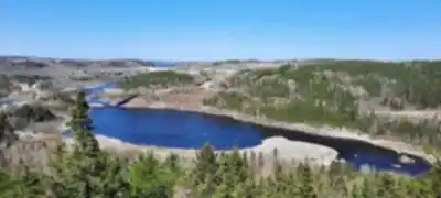
Mont Fortin is a challenging hiking destination in the Saguenay - Lac-Saint-Jean region that delivers exactly what serious hikers are looking for: a proper workout with rewarding views at the top. This 8-kilometer round trip with 1,020 meters of elevation gain isn't a casual afternoon stroll—it's a committed 4.5-hour adventure that earns its "hard" difficulty rating through steep climbs and sustained effort.
What makes this hike challenging
The numbers tell the story here: over 1,000 meters of elevation gain packed into 8 kilometers means you're climbing consistently from start to finish. The trail doesn't mess around with gentle warm-ups—you'll feel the incline early and maintain it through most of the ascent. Your legs will know they're working, and your heart rate will reflect the sustained effort required to reach the summit.
The terrain varies as you climb, starting in dense forest where the canopy provides shade but also creates a humid, enclosed feeling during warmer months. As you gain elevation, the forest character changes, and you'll encounter rockier sections and more exposed areas where the grade can feel particularly steep. The final push to the top demands focus and determination, especially when your legs are already feeling the accumulated elevation.
The payoff at the summit
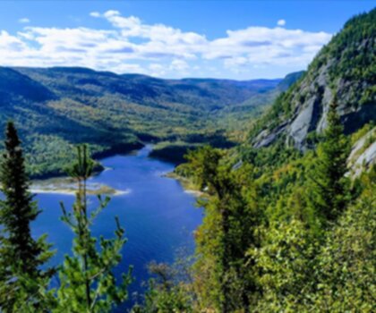
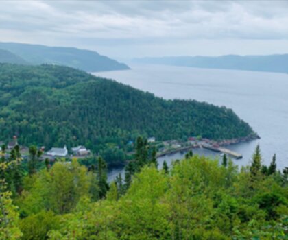
Those 1,020 meters of climbing deliver panoramic views that justify every step of the ascent. From the summit of Mont Fortin, the Saguenay - Lac-Saint-Jean landscape spreads out below in a way that makes the effort feel worthwhile. You can see the broader geography of the region—the way valleys cut between ridges, how forests stretch toward distant horizons, and the patterns that water and elevation create across this part of Quebec.
The views change dramatically with the seasons, offering different rewards depending on when you tackle the climb. Fall brings the classic burst of autumn colors that makes every photo look like a postcard, while winter transforms the landscape into a stark, beautiful scene of snow-covered forest and distant peaks. Even summer and spring offer their own character, with lush green canopies and the kind of clear air that makes distant features sharp and defined.
Who should attempt this hike
Mont Fortin is designed for hikers who want a genuine challenge and have the fitness level to handle sustained climbing. If you're comfortable with steep terrain and can maintain effort for several hours, this mountain will give you the kind of satisfying workout that leaves you feeling accomplished. It's not a beginner-friendly option—the combination of distance, elevation gain, and difficulty rating means you should have solid hiking experience before attempting this route.
The 4.5-hour timeframe assumes a steady pace with reasonable breaks, but hikers should be prepared for the possibility of taking longer if conditions are challenging or if you want to spend significant time at the summit enjoying the views. Strong hikers might complete it faster, while others may need the full duration or more, especially if weather or trail conditions add complexity to the climb.
Trail conditions and terrain
The trail moves through varied terrain that keeps the hike interesting even as it demands consistent effort. You'll start in thick forest where the path can be rooty and uneven, requiring attention to foot placement and balance. As you climb higher, expect rockier sections where the trail becomes more technical, demanding careful navigation and potentially some scrambling over larger obstacles.
The sustained elevation gain means you're rarely walking on flat ground—your muscles are constantly adjusting to the incline, and your balance is continuously engaged as the trail winds upward. Weather can significantly impact trail conditions, with wet rocks becoming slippery and winter conditions adding the complexity of snow and ice to an already challenging route.
Wildlife and forest ecosystem
The elevation gain on Mont Fortin takes you through different forest zones, each supporting its own mix of plant and animal life. The lower elevations feature dense deciduous and mixed forest, while higher areas transition to different vegetation adapted to the more exposed, windier conditions near the summit. This variety creates opportunities to observe how ecosystems change with altitude, even within a single hike.
Wildlife sightings are possible throughout the climb, particularly in the quieter forest sections where animals may be less disturbed by human activity. Birds are especially active in the varied habitats along the route, and the changing elevation provides different vantage points for spotting movement in the canopy or listening for calls echoing through the valleys.
Preparation and safety considerations
A hike of this difficulty and duration requires serious preparation. Proper hiking boots with good ankle support and aggressive tread are essential—the steep terrain and potentially loose rocks demand footwear that can handle technical conditions. Bring more water than you think you'll need; the sustained climbing and 4.5-hour duration mean you'll be sweating and working hard for an extended period.
Pack substantial snacks or a lunch, as your body will need fuel to maintain energy through the long climb and descent. The summit is an ideal place to rest and refuel while enjoying the views, but you'll also want to eat during the ascent to maintain your energy levels. Weather can change quickly at elevation, so bring layers that allow you to adjust as conditions shift from the sheltered forest to the more exposed summit.
Let someone know your hiking plans, including your expected return time. A hike of this difficulty in mountain terrain carries inherent risks, and having people aware of your whereabouts adds an important safety margin. Check weather conditions before you start, as storms or high winds can make the exposed sections near the summit dangerous.
The complete Mont Fortin experience
Mont Fortin represents serious hiking in the Saguenay - Lac-Saint-Jean region. It's the kind of mountain that demands respect, preparation, and genuine effort, but rewards that investment with an experience that feels truly earned. The combination of sustained climbing, varied terrain, and spectacular summit views creates a hike that satisfies experienced hikers looking for a real challenge.
This isn't a mountain you conquer casually—it's a destination that requires commitment and delivers proportional rewards. With proper preparation, appropriate fitness levels, and respect for the mountain's demands, Mont Fortin offers one of the region's most satisfying and challenging hiking experiences.
Services and amenities
This information may vary by season.
Recommended gear for this trail


Ready to go?
Everything you need to know before you goStarting Point
To access the hiking trails, head to the main trailhead located at 300 Chemin de la Montagne, Saint-Fulgence, QC G0V 1S0. There is a parking lot available at this address. Additionally, there is another possible trailhead at 150 Rue du Quai, Sainte-Rose-du-Nord, QC G0V 1T0, which also offers parking facilities.
When?
Tuesday: Closed
Wednesday: 1:00 – 4:00 PM, 6:00 – 9:00 PM
Thursday: 1:00 – 4:00 PM, 6:00 – 9:00 PM
Friday: 1:00 – 4:00 PM, 6:00 – 9:00 PM
Saturday: 9:30 AM – 4:00 PM
Sunday: 9:30 AM – 4:00 PM
How much?
- Hiking shoes Essential
- → Salomon Elixir Tour Mid WP · 203.38 $
- Layered clothing Essential
- Rain jacket Essential
- Trekking poles
- → Black Diamond Trail Ergo Cork · 69.99 $
- Headlamp
- → Petzl Actik Core 625 · 103.95 $
FAQ - Frequently asked questions
Everything you need to knowTuesday: Closed
Wednesday: 1:00 – 4:00 PM, 6:00 – 9:00 PM
Thursday: 1:00 – 4:00 PM, 6:00 – 9:00 PM
Friday: 1:00 – 4:00 PM, 6:00 – 9:00 PM
Saturday: 9:30 AM – 4:00 PM
Sunday: 9:30 AM – 4:00 PM
The Essential Hiking Checklist
Everything you need for your next hike. Bilingual, printable, 1 page.
Download the free checklistSimilar hikes nearby
Discover other trails you might enjoy
Parc National Du Fjord-du-saguenay
Saguenay - Lac-Saint-Jean
Parc National De La Pointe-taillon
Saguenay - Lac-Saint-Jean

Parc National Des Monts-valin
Saguenay - Lac-Saint-Jean
Sainte-rose-du-nord
Saguenay - Lac-Saint-Jean

Les Sentiers Du Saguenay
Saguenay - Lac-Saint-Jean

Parc De La Rivière Du Moulin
Saguenay - Lac-Saint-Jean
Hiking near Quebec City
40 trails to explore ~180 km away
We work hard to provide the most up-to-date and error-free data possible. If something seems incorrect, let us know! Your contribution helps the whole community.
Hikers' opinions