

Ready to explore Parc des Chutes de Montauban? Here's everything you need to know before you go!
Discover the trail

Available trails
| Trails | Distance | Elevation | Duration | Difficulty | GPX |
|---|---|---|---|---|---|
| 3.4 km | 200 m | 1h | Intermediate | ||
| 17.4 km | 200 m | 4h30 | Intermediate |
Trail description
Description
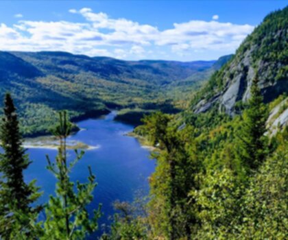
Parc des Chutes de Montauban is one of those places that rewards you the moment you step out of the car. Located in the Mauricie region of Quebec, this park is built around a dramatic waterfall system that gives it its name — and the trail network that surrounds it makes for a genuinely satisfying day out in the forest.
The Trail
The main hiking loop at Parc des Chutes de Montauban covers 17.4 km with 200 m of elevation gain, rated Moderate with an estimated time of 5 hours 30 minutes. That's a solid half-day commitment, but the terrain keeps things interesting throughout. The elevation profile is gentle enough that most reasonably fit hikers won't find it punishing, but the distance means you'll want to pace yourself and bring enough food and water for the full stretch.
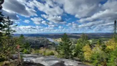
The trail winds through a mixed boreal forest typical of this part of Quebec — spruce, fir, and birch dominate the canopy, with the forest floor shifting between rocky outcrops and softer, moss-covered ground depending on where you are on the loop. The path is generally well-defined, but there are sections where roots and uneven footing demand a bit of attention, especially after rain.
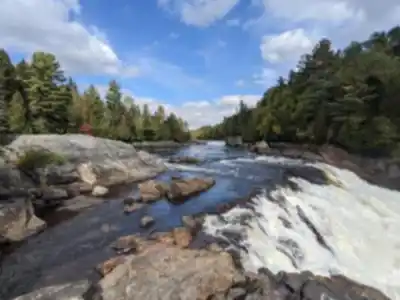
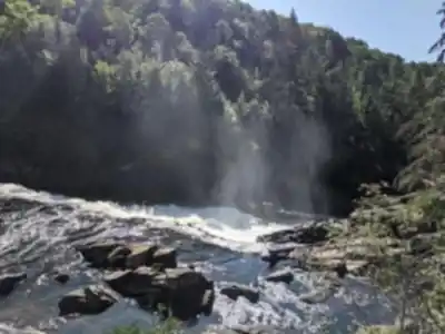
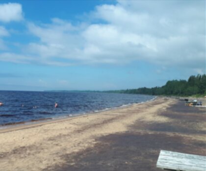
The Waterfalls
The chutes themselves are the centerpiece of the park and the main reason most people make the trip. The falls drop dramatically into a gorge carved over thousands of years, and the viewpoints along the trail give you multiple angles on the cascade — from above, from the side, and at closer range near the base. It's the kind of scenery that makes you stop walking and just stand there for a few minutes, which is exactly what you should do.
The sound of the falls carries well through the forest, so you'll often hear them before you see them. Early in the season, when snowmelt is feeding the watershed, the volume and force of the water is at its peak. Later in summer, the flow mellows out but the surrounding vegetation is at its fullest, which creates its own kind of atmosphere.
What to Expect on the Trail
At 17.4 km, this isn't a quick out-and-back — plan your day accordingly. The 5h30 estimate assumes a steady pace with short stops. If you're the type to linger at viewpoints, eat lunch by the water, or take a lot of photos, budget closer to 6 to 7 hours. There's no shame in that — this trail is worth taking your time on.
The 200 m of elevation gain is spread across the loop rather than concentrated in one steep climb, which makes the moderate rating feel accurate. You'll notice the terrain rolling up and down in sections, but there's no single stretch that's going to stop you in your tracks. Trekking poles aren't necessary, but they're useful on the descent sections if your knees appreciate the extra support.
Footwear matters here. Trail runners or light hiking boots with decent grip are the right call. The trail surface varies — packed dirt, exposed roots, some rocky sections near the gorge — and regular sneakers will leave you slipping around more than you'd like, particularly near the water.
Practical Information
- Distance: 17.4 km loop
- Elevation gain: 200 m
- Difficulty: Moderate
- Estimated time: 5 hours 30 minutes
- Location: Mauricie region, Quebec, Canada
The park has a parking area at the trailhead. Arrive earlier in the day on weekends during peak season — the falls are a popular destination and the lot fills up. There are facilities on site, including washrooms near the entrance area.
Check trail conditions before heading out, especially during spring thaw or after heavy rainfall. Sections near the gorge can be slippery, and water levels affect how accessible some of the lower viewpoints are. The park's management keeps the main trail in good shape, but it's always worth a quick check before a longer outing like this one.
Who This Trail Is For
Parc des Chutes de Montauban works well for hikers who want more than a short nature walk but aren't looking to tackle something technical. The combination of distance and scenery makes it a good choice for people building up their trail mileage, for groups with mixed experience levels, or for anyone who just wants a full day in the woods with a genuinely impressive natural feature as the payoff.
Families with older kids who are comfortable on uneven terrain will find this manageable. Younger children or those not used to longer distances might find the full loop a stretch — in that case, the trail near the falls themselves is worth doing as a shorter out-and-back just to see the main attraction.
Getting There
Parc des Chutes de Montauban is located in the Mauricie region of Quebec. The park is accessible by car, and the drive in takes you through the kind of rural Quebec landscape that sets the mood well before you even hit the trailhead. Signage in the area directs you to the park entrance without much difficulty.
If you're coming from further away and making a full day of it, there are small communities nearby where you can grab supplies before heading in — it's worth topping up on water and snacks before you start, since there are no services on the trail itself once you're out there.
Services and amenities
This information may vary by season.
Recommended gear for this trail


Ready to go?
Everything you need to know before you goStarting Point
To get to the Mount Otis trails, you must go to Shawinigan-Sud. From there, take route 155 towards Saint-Étienne-des-Grès. After about 9 km, turn left onto Chemin du Mont Otis. The trailhead is about 1 km from the road.
When?
How much?
- Hiking shoes Essential
- → Salomon Elixir Tour Mid WP · 203.38 $
- Layered clothing Essential
- Rain jacket Essential
- Trekking poles
- → Black Diamond Trail Ergo Cork · 69.99 $
- Headlamp
- → Petzl Actik Core 625 · 103.95 $
FAQ - Frequently asked questions
Everything you need to knowThe Essential Hiking Checklist
Everything you need for your next hike. Bilingual, printable, 1 page.
Download the free checklistSimilar hikes nearby
Discover other trails you might enjoy
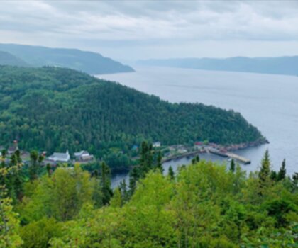
Parc National Du Fjord-du-saguenay
Saguenay - Lac-Saint-Jean
Parc National De La Pointe-taillon
Saguenay - Lac-Saint-Jean

Parc National Des Monts-valin
Saguenay - Lac-Saint-Jean
Sainte-rose-du-nord
Saguenay - Lac-Saint-Jean

Les Sentiers Du Saguenay
Saguenay - Lac-Saint-Jean

Parc De La Rivière Du Moulin
Saguenay - Lac-Saint-Jean
Hiking near Quebec City
40 trails to explore ~84 km away
We work hard to provide the most up-to-date and error-free data possible. If something seems incorrect, let us know! Your contribution helps the whole community.
Hikers' opinions