

Ready to explore Baie des Ha! Ha!? Here's everything you need to know before you go!
Discover the trail
Oh no! We don't have any photos 😢
This trail hasn't been captured yet. Be the first to share your adventure!Trail description
Description
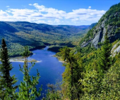
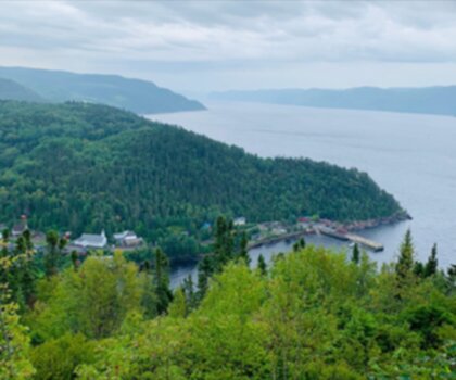
Baie des Ha! Ha! is one of those spots in the Saguenay–Lac-Saint-Jean region that earns its place on a day-trip list without making a big fuss about it. The name alone tends to get a reaction, but once you're there, the setting does the talking. It's a scenic bay where the forest meets the calm waters of the Saguenay River, framed by rolling hills and rugged cliffs that give the whole landscape a layered, unhurried kind of drama.
The trail here is a combined cycling and walking path—the Piste cyclable et de marche de la Baie des Ha! Ha!—which means the surface is generally well-maintained and easy to follow. At 6 km with around 200 m of elevation gain, it sits comfortably in the easy category, and most people will complete it in about 2 hours. That said, easy doesn't mean boring—the route moves through enough different terrain and opens up to enough good views that it holds your attention throughout.
What the trail is like underfoot
The path alternates between stretches of shaded forest and more open sections where the bay comes into view. In the forested parts, the light filters through the canopy and the air has that cool, damp quality you get near water—it's the kind of walking where you naturally slow down a little and start noticing things. The open sections feel different: brighter, wider, with longer sightlines across the water and toward the hills on the far side.
The elevation gain is spread out enough that you won't feel it as a grind. There are gentle rises and dips along the way, but nothing that requires a change of pace or any technical footing. The shared-use surface means the path is generally smooth and consistent, which makes it a solid choice if you're hiking with kids, older family members, or anyone who prefers a more predictable surface underfoot.
Views and what to look for along the way
The bay is the anchor of the whole experience. When the trail opens up toward the water, you get those wide, calm views that the Saguenay region is known for—the bay stretching out below, the surrounding hills and cliffs rising behind it, and the kind of quiet that makes you want to stop and just look for a minute. These aren't manufactured viewpoints with a bench and a sign; they're natural pauses in the route where the landscape opens up and does its thing.
Keep an eye on the edges of the trail as you move through the forested sections. The transition zones between forest and open ground tend to be the most active spots for birds and small wildlife. In the meadow-like stretches, the sightlines are better and the light is clearer, which makes it easier to catch movement or pick out details in the plant life along the path.
Who it works well for
The easy rating and well-marked route make Baie des Ha! Ha! a genuinely flexible outing. It works for families with younger kids who need a manageable distance and a clear path. It works for people who want a low-key day outside without committing to something more demanding. And it works for anyone who just wants to spend a couple of hours near the water without overthinking it.
Because the path is shared with cyclists, it's worth being aware of bike traffic on the route—especially on weekends or during peak summer months. It's not a crowded trail by any measure, but the shared-use format is worth keeping in mind if you're hiking with young children or a dog.
Beyond the trail
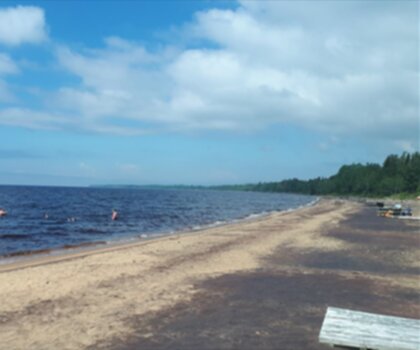
The bay itself invites more than just walking. The calm water is well-suited to kayaking if you want a different perspective on the shoreline and the surrounding cliffs. Birdwatching is another natural fit—the mix of forest edge, open water, and meadow sections along the route creates good habitat variety, and the quieter pace of the trail gives you time to actually look and listen. If you want to keep things simple, the water's edge makes an easy spot to stop for lunch and let the afternoon stretch out a bit.
What to bring
Comfortable walking shoes or light hiking footwear will handle the surface well. Bring water and a snack, especially if you plan to linger at the viewpoints or add time near the bay after the hike. If you're planning to kayak or spend extra time outside, think of the day as a flexible block rather than a single activity with a fixed endpoint—the area rewards that kind of unhurried approach.
Baie des Ha! Ha! is the kind of place that's easy to underestimate on paper and easy to appreciate once you're actually there, moving through the forest with the bay showing through the trees.
Recommended gear for this trail


Ready to go?
Everything you need to know before you goStarting Point
To access the hiking trails, you can start at the main trailhead located at the parking lot on Route 172. If you're coming from the nearby town, head north on Route 170 and then take a right onto Route 172. Continue for approximately 15 kilometers until you reach the designated parking area. There are no alternative trailheads for this location.
When?
How much?
- Hiking shoes Essential
- → Salomon Elixir Tour Mid WP · 203.38 $
- Layered clothing Essential
- Rain jacket Essential
- Trekking poles
- → Black Diamond Trail Ergo Cork · 69.99 $
- Headlamp
- → Petzl Actik Core 625 · 103.95 $
FAQ - Frequently asked questions
Everything you need to knowThe Essential Hiking Checklist
Everything you need for your next hike. Bilingual, printable, 1 page.
Download the free checklistSimilar hikes nearby
Discover other trails you might enjoy
Parc National Du Fjord-du-saguenay
Saguenay - Lac-Saint-Jean
Parc National De La Pointe-taillon
Saguenay - Lac-Saint-Jean

Parc National Des Monts-valin
Saguenay - Lac-Saint-Jean
Sainte-rose-du-nord
Saguenay - Lac-Saint-Jean

Les Sentiers Du Saguenay
Saguenay - Lac-Saint-Jean

Parc De La Rivière Du Moulin
Saguenay - Lac-Saint-Jean
Hiking near Quebec City
40 trails to explore ~173 km away
We work hard to provide the most up-to-date and error-free data possible. If something seems incorrect, let us know! Your contribution helps the whole community.
Hikers' opinions