

Ready to explore Beauvais Lake? Here's everything you need to know before you go!
Discover the trail
Oh no! We don't have any photos 😢
This trail hasn't been captured yet. Be the first to share your adventure!Trail description
Description
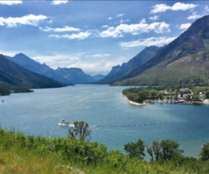
Beauvais Lake sits quietly in the foothills of the Canadian Rockies, just a short drive from Pincher Creek in southwestern Alberta. This provincial park delivers a genuine mountain experience without the crowds or complexity of the bigger Rocky Mountain parks—you get clear water, forested trails, and views of the Southern Rockies peaks, all within easy reach of the parking area.
The lake occupies a valley floor ringed by rolling, forested hills, with the more dramatic peaks of the Southern Rockies visible in the distance. What makes this place work so well is the contrast: you can drive right to the park, step out of your car, and within minutes feel genuinely removed from everything. The transition zone between Alberta's foothills and the mountain ecosystem gives the area a richness that's easy to underestimate on a map.
The Hiking
The trail at Beauvais Lake covers 2.4 km with 200 meters of elevation gain, rated Easy with an estimated time of about 1 hour. That combination makes it accessible to a wide range of hikers—families with kids, people returning to hiking after a break, or anyone who wants a solid outing without committing to a full-day push.
The route moves through varied terrain for its length. You'll pass along the lakeshore on relatively flat ground, where the water reflects the surrounding hills and the pace naturally slows down. From there, the trail climbs through dense spruce and fir forest, gaining that 200 meters as it works up into the wooded slopes above the lake. The elevation gain is steady rather than punishing, and the forest canopy keeps things cool on warmer days.
The well-marked paths make navigation simple, and the diversity of terrain—shoreline, forest, and open areas with broader views—keeps the hike engaging from start to finish. It's a compact trail that punches above its weight in terms of what you actually see and experience along the way.
Wildlife and Natural Features
The lake supports a healthy population of rainbow trout, which draws anglers alongside hikers. The clear, cold water makes for excellent photography, particularly in the early morning when the surface is calm and the surrounding hills are reflected cleanly.
Birdwatchers will find the area productive. Ospreys and bald eagles are regularly spotted above the lake and nesting in the tall trees along the shoreline. The mix of wetland habitat near the water, dense forest on the slopes, and more open terrain creates conditions that support a wide variety of bird species through the hiking season.
The park's position in the transition zone between prairie and mountain ecosystems means the biodiversity here is genuinely interesting. As you move through the different sections of the trail, the character of the landscape shifts noticeably—from the open, reflective quality of the lakeshore to the enclosed, shaded feel of the forest interior.
Beyond the Trail
Beauvais Lake is well set up for a full day out. The calm water is ideal for canoeing and kayaking, letting you explore the lake from a completely different angle and reach quieter coves that aren't visible from the trail. The shoreline has good spots for picnicking and relaxing after a hike, and combining time on the water with time on the trail is an easy way to stretch a visit into a full afternoon.
For those who want to stay longer, the park offers camping facilities for both tent campers and RV users. The campsites sit among mature trees, which provides natural shelter and privacy while keeping you close to the trailhead and the lake. Staying overnight means early morning access to the trails before day visitors arrive, and the low light pollution in this part of Alberta makes for good stargazing after dark.
Getting There
Beauvais Lake Provincial Park is located a short drive from Pincher Creek, Alberta, in the Southern Rockies foothills. The drive in passes through open foothills country before the terrain tightens up around the park. Access is straightforward, and the park is suitable for day trips as well as multi-night stays. It works well as a standalone destination or as a base for exploring the broader Southern Rockies region.
Recommended gear for this trail


Ready to go?
Everything you need to know before you goStarting Point
The beauvais lake trails can be accessed from the east side of the lake. There is a parking lot and trailhead located there.
When?
How much?
- Hiking shoes Essential
- → Salomon Elixir Tour Mid WP · 203.38 $
- Layered clothing Essential
- Rain jacket Essential
- Trekking poles
- → Black Diamond Trail Ergo Cork · 69.99 $
- Headlamp
- → Petzl Actik Core 625 · 103.95 $
FAQ - Frequently asked questions
Everything you need to knowThe Essential Hiking Checklist
Everything you need for your next hike. Bilingual, printable, 1 page.
Download the free checklistSimilar hikes nearby
Discover other trails you might enjoy

Crypt Lake Trail
Southern Rockies
Waterton Lakes National Park of Canada
Southern Rockies

Lundbreck Falls
Southern Rockies

Castle Mountain Resort
Southern Rockies
Blakiston Falls
Southern Rockies
Lower Bertha Falls
Southern Rockies
Hiking near Calgary
120 trails to explore ~182 km away
We work hard to provide the most up-to-date and error-free data possible. If something seems incorrect, let us know! Your contribution helps the whole community.
Hikers' opinions